

서론
이란은 석유의 확인매장량이 157.8 Bbbl (billion barrels)로 세계 4위(또는 캐나다와 베네수엘라의 오일샌드를 제외하면 사우디아라비아에 이어 세계 2위)이며, 천연가스의 확인매장량은 1201.4 Tcf (trillion cubic feet)로 러시아에 이어 세계 2위이고, 합산할 경우 세계 1위의 탄화수소 자원 보유국이다(U.S. EIA, 2015).
이란은 1979년 이슬람 혁명 전에는 600만 배럴/일 이상을 생산하여 세계 4위의 석유 생산국이었으나, 이란-이라크 전쟁(1980~1988)으로 200만 배럴/일 수준으로 급격하게 감소한 후, 1990년대 ~370만 배럴/일로 회복하고, 2004년부터 >400만 배럴/일을 생산하였다(U.S. EIA, 2015). 2012년 이란의 우라늄 농축에 따른 서방의 강력한 제재로 석유 수출이 급격히 감소하여(250만 배럴/일→2013년 100만 배럴/일), 2015년 생산이 345만 배럴/일로 줄어들었다가, 2016년 핵 문제가 해결 국면으로 접어들면서 거의 제재 이전 수준인 380만 배럴/일로 회복하는 등 부침이 심했다.
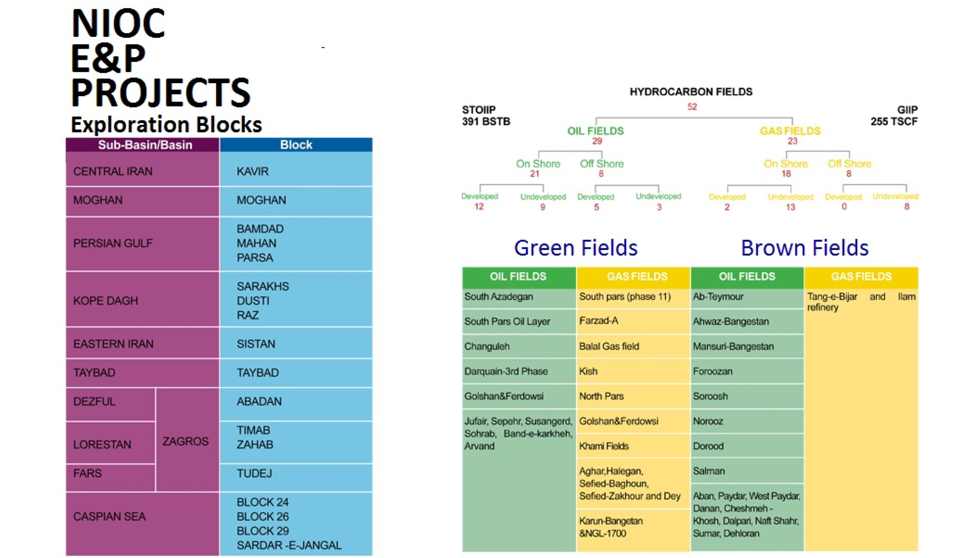
이란의 생산 능력은 혁명 이후 국제적 석유회사(IOC, International Oil Company)들의 철수로 기존 유전에 대한 관리 및 보수가 원활히 이루어지지 않고, 신규 유전 개발 지체와 석유회수증진(EOR, Enhanced Oil Recovery) 등 선진 기술 도입 부진으로 심각한 수준으로 감쇄된 상태이다. 2016년 1월 16일을 기해 이란 혁명과 미국 대사관 인질 사건, 핵 프로그램 등으로 야기되었던 국제 사회의 각종 경제적 제재들이 상당 부분 해제됨에 따라, 심각하게 타격을 받았던 석유‧가스 분야에 대한 투자 유치가 활발히 진행 중이다. 최근 이란은 석유법을 개정하여 IOC를 서비스 공급자로만 취급하여 소유권을 인정하지 않고 환매(Buyback) 권리만 인정하는 계약 형태를, 보편적인 생산물 분배계약(PSA, Product Sharing Agreement)을 부분적으로 수용한 새로운 형태의 계약(IPC, Iranian Petroleum Contract)으로 대체하고, 총 투자비 1,530억불이 예상되는 49개 석유‧가스 개발 사업에 대한 공모를 추진하고 있다(Fig. 1)(이란 IPC 인터넷 사이트, http://ipc.nioc.ir). 이를 통해 궁극적으로 280억 배럴 상당의 석유를 개발 생산하여, 석유 120만 배럴/일, 가스 12.5 Bcf/일을 증산하고자 한다.

우리나라는 이란과 삼국시대로부터 교류해 왔고, 1962년 수교 이후 1970년대부터 이란 내 건설 시장에 꾸준히 참여해 왔으며, 제재 하에서도 상당량의 석유를 수입하여 신뢰도가 깊고, 최근 드라마 등을 통해 이란 국민들에게 문화적으로도 친근해진 나라이다. 우리 기업들이 철저하게 준비하여 이번 기회를 잘 활용한다면, 막대한 매장량이 잠재한 이란의 석유 사업에의 교두보 확보를 기대할 수도 있으며, 침체된 해외자원개발 사업이 재도약할 수 있는 기회가 될 것이다.
이 논문은 이란의 지체 구조 및 광역 지질을 개관하고, 이란 석유의 대부분이 부존하는 자그로스(Zagros)의 구조, 층서, 퇴적상 등의 기본 지질과 함유 구조, 저류 특성, 유기 지화학 등 석유지질적 요소들을 집중 분석하였다. 이 논문이 향후 이란 지역의 탐사 및 개발 사업에 기본 자료로 널리 활용될 수 있기를 바란다.
국가 정보
지리‧기후
이란은 지리적으로 중동, 중앙아시아, 남아시아가 교차하는 중심에 위치하고 동서양을 연결하는 실크로드가 통과하여, 세력 균형과 교역 측면에서 전략적으로 중요한 거점 지역이었으며, 석유가 발견된 근대 이후에는 열강의 지속적인 각축장이었다. 이란은 동쪽으로 아프가니스탄, 파키스탄, 북쪽으로 아제르바이잔, 아르메니아, 투르크메니스탄, 서쪽으로 터키, 이라크와 접하며, 바다는 남쪽으로 페르시아 만, 오만 만, 북쪽으로 카스피 해에 면해 있다(Fisher, 1968; Curtis and Hooglund, 2008; Ministry of Foreign Affairs, Iran, 2016). 면적은 1,648,195 km2로, 북위 24°~40°, 동경 44°~64° 사이에 있고, 미국의 1/6 또는 영국, 프랑스, 스페인, 독일을 합한 크기와 비슷하다(Fig. 2).
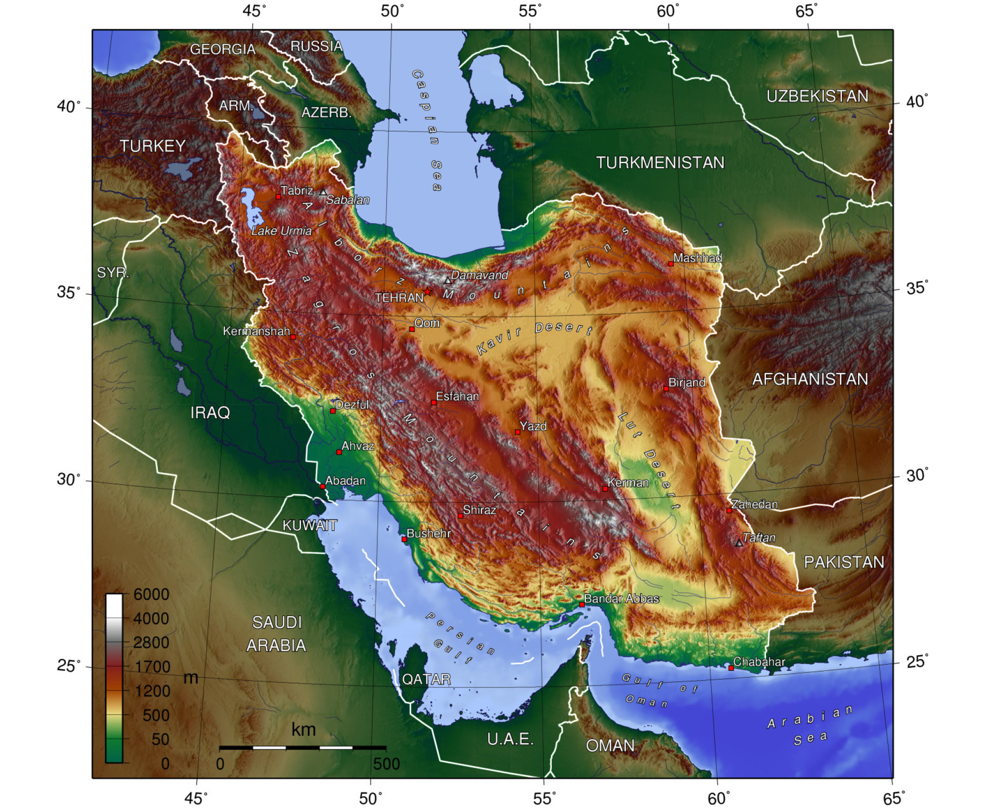
이란은 아라비아 판과 유라시아 판 사이에서 융기된 해발고도 500~1,500 m의 고원과 이를 둘러싸는 자그로스, 알보르즈(Alborz, 또는 엘부르즈 Elburz) 등 3,000~4,000 m 급의 산맥들이 지형을 형성한다. 국토의 절반 이상이 산악 지대이며, 중앙 고원은 이들에 의해 비구름이 막혀 강수량이 극히 적어서 카비르(Kavir), 루트(Lut) 등 광활한 염성 사막이 발달해 있다. 저지대 평원은 페르시아 만 북단에 위치한 메소포타미아 평원의 일부에 속하는 후제스탄(Khu-zestan) 평원과 카스피 해 연안 평원으로, 높은 생산성의 농업 지대를 구성한다.
기후는 지역에 따라 많은 차이를 보이는데, 내륙 고원은 건조한 대륙성 또는 사막 기후, 페르시아 만 연안은 아열대성 기후, 카스피 해 연안은 비가 잦은 지중해성 기후, 북부 산간은 겨울 추위가 극심하고 적설량이 많은 고산 기후를 나타낸다(Fig. 3(a)). 지역에 따른 연평균 기온은 10°C~30°C이며, 오만 해 인접 사막의 경우 여름 최고 기온이 55°C, 북부 산간은 겨울 최저 기온이 –20°C에 이른다. 연평균 강우량은 300~350 mm이며, 동부와 중부 지역은 100 mm 이하로 매우 적고, 카스피 해 연안은 최대 2,000 mm에 달한다(Fig. 3(b)).
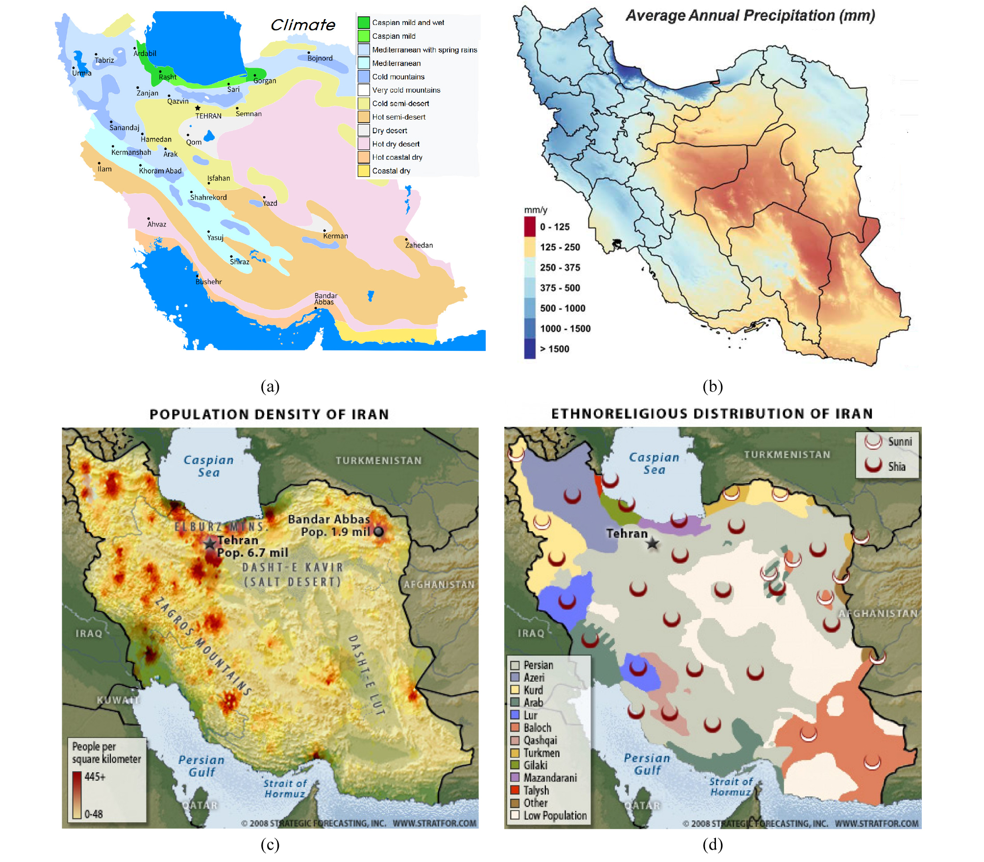
Fig. 3.
(a) Climate of Iran (After https://en.wikipedia.org/wiki/Geography_of_Iran), (b) Average annual precipitation in Iran (After Mesgaran et al., 2016), (c) Population density of Iran (Taken from https://worldview.stratfor.com/article/geopolitics-iran-holding-center-mountain-fortress), (d) Ethno-religious distribution of Iran (Ibid.).
역사‧정치
이란은 중동에 속하지만 민족적, 역사적, 종교적 배경이 사우디아라비아를 비롯한 아라비아 반도의 국가들과 매우 다르다. 이란인은 기원전 2,500년경 중앙아시아 초원으로부터 이주하여 이란 고원에 정착한 아리아인으로, 셈족(Semite)에서 분화되어 나온 아랍인, 유대인과는 기원이 상이하고, 계통적으로 인도인 및 유럽인과 유사하다(Fisher, 1968; Ministry of Foreign Affairs, 2016). 이란의 국호도 ‘아리아인의 땅’이라는 뜻으로, 팔레비 왕조를 세운 레자 샤(Reza Shah)가 외세의 간섭에서 벗어나 근대화된 새로운 나라를 만들겠다는 의지로 1935년 그리스어에서 유래된 ‘페르시아’를 폐기하고 채택한 명칭이다.
이란은 제국의 역사를 가졌었던 국가로 기원전 5세기경 아케메네스 왕조 다리우스 1세의 고대 페르시아 제국은 인도 북부에서 불가리아 남부에 이르는 광대한 영토를 지배했었으며, 기원전 2세기부터 기원후 7세기의 파르티아와 사산 왕조는 로마 제국과 그 뒤를 이은 비잔틴 제국과 동서양의 패권을 다퉜던 대국이었다. 하지만 7세기부터 16세기까지의 중세시대는 아랍 족, 투르크 족, 몽골 족에 의해 차례로 정복당해 1,000년 가까이 이민족의 지배를 받은 이란 역사의 암흑기로, 고유 언어인 팔레비어 대신 아랍어가 쓰이고, 종교도 전통적인 조로아스터교에서 이슬람교로 대체되었다. 1502년 사파비 왕조가 일어나면서 강력한 민족국가를 형성하고, 시아파 이슬람교를 국교로 정하여 수니파 오스만투르크 제국에 끊임없이 대항하면서, 압바스 샤(Abbas Shah: 1587-1629)의 치세에는 수도 이스파한이 ‘세계의 절반’(Nesf-e Jahan)이라 불릴 만큼 융성하였다. 그후 아프샤르(Afshar: 1736-1749), 잔드(Zand: 1750-1794), 카자르(Qajar: 1794-1925) 등 여러 왕조가 부침을 거듭하는 혼란기가 이어지고(Avery et al., 1991), 19세기 중엽 러시아와 영국에게 침략을 당하면서 각각 코카서스와 아프간을 빼앗겼다. 1907년 러시아와 영국은 영러 조약을 체결하여 이란을 양분하고 반식민지 국가로 만들어 본격적으로 수탈하기 시작하였고, 1917년 공산혁명으로 러시아의 영향력이 약화되자, 1918년 영국은 이란을 보호령화하는 조약을 체결하였다. 이에 항거하여 1921년 레자 한(Reza Khan)이 반란을 일으켜, 1925년 카자르 왕조를 종식시키고 샤로 등극하여 팔레비 왕조를 열면서, 근대화에 박차를 가하고, 지속적으로 유럽세력 배제를 위한 투쟁을 펼쳤다(Abraha-mian, 2008). 제2차 세계대전이 발발하면서 1941년 레자 샤는 연합국에 의해 강제로 폐위되고 아들 모하마드 팔레비(Mohammad Reza Pahlavi)가 즉위하였다. 그해 소련과 영국이 이란을 침공하고 연합국의 병참기지가 되면서, 이란인들은 생필품 부족, 물가 급등 등으로 극심한 경제적 어려움을 겪게 되고, 반외세 감정이 극도로 높아지게 된다.
종전 후 민족주의를 내세운 국민전선의 지도자 모사데그(Mohammad Mosaddegh)가 1951년 총리로 취임하면서 유전 국유화를 단행하였다. 그때까지 이란 석유에 대해 독점적 권리를 누렸던 영국은 유럽 국가들과 연대하여 이란의 석유 수입 금지, 자금 차단 등 경제적 압박을 가하기 시작하였으며, 1953년 미국은 이란 군부를 사주하여, 쿠데타로 모사데그를 실각시키고, 국외 망명 중이던 팔레비 국왕을 복귀시키면서, 이후 이란에 대해 막강한 영향력을 갖게 된다. 팔레비 국왕은 친미, 친영 노선을 노골화하고, 1955년 소련의 중동 진출을 막기 위해 결성된 바그다드 조약기구에 가입한데 이어, 1959년 미국과 방위 조약을 체결하고 미군 주둔을 허용하였다. 1960년대 이후 석유 판매액이 급격히 증가하면서 경제 발전을 이루고, 토지 개혁, 근로자에 대한 이윤 분배, 문맹 퇴치, 여성에게 선거권 부여 등 소위 ‘백색혁명’을 통한 개혁을 추진했으나, 이슬람 전통을 무시한 급격한 변화에 대한 반발, 지나친 친미에 대한 굴욕감, 왕정의 부패와 무능, 빈부격차 심화, 비밀경찰을 동원한 성직자 및 반대파들에 대한 무자비한 탄압 등이 쌓이게 되면서, 1979년 마침내 팔레비 왕조는 민중 혁명으로 무너지게 된다.
1979년 호메이니가 귀국하고 최고 이슬람 혁명위원회가 수립되어 사실상 정부 역할을 수행하다가, 그해 말 이슬람 공화정을 표방한 신헌법을 채택하였다. 초기에는 혁명 세력 내부의 성직자와 비종교적 자유주의자 및 급진주의자 파벌 간의 권력 투쟁으로 정정이 불안했으나, 궁극적으로 성직자 계급이 승리하여 이슬람 교리를 기본으로 삼은 정치‧사회 질서 규범을 제도적으로 완성해 나가게 된다. 1979~1981년 과격파 학생들에 의한 미국 대사관 인질 사건은 미국과의 관계를 회복 불능 상태로 악화시켰으며, 이슬람 근본주의의 확산을 우려하는 사우디아라비아 등 온건‧친미‧군주국들로부터의 소외를 초래하였다. 이러한 가운데 1979년 이라크의 정권을 잡은 사담 후세인은 혁명으로 군사력이 약화된 이란을 병탄하고, 사다트의 이스라엘과의 평화회담 조인으로 공백이 된 아랍 맹주 역할을 차지할 야심으로, 1980년 샤트 알 아랍(Shatt al-Arab) 수로의 영유권 수복을 표면적으로 내세우면서, 주변 아랍국들의 명시적, 암묵적 지지를 받으며 이란을 침공하였다. 이란-이라크 전쟁은 초반에는 이라크가 우세를 보였으나, 이란의 혁명 수호 의지가 공고해지고 단결되면서 지루한 소모전에 돌입하였고, 1988년 UN의 수년에 걸친 중재로 결국 승자 없이 종식되었다.
1989년 호메이니가 사망하고, 이란은 1인이 절대적인 영향력을 갖는 지배 체재에서 벗어나 정상적인 국가의 길을 걸을 수 있게 되었는데, 민주화와 개방을 지향하는 개혁파와 이슬람 혁명의 수호 세력을 자처하는 보수파의 양대 세력이 대립하면서 국정을 이끌게 된다. 전쟁 직후 대통령에 당선된 라프산자니(Akbar Hashemi Rafsanjani, 1989-1997)는 전쟁으로 피폐해진 경제 회생에 힘쓰는 한편, 국제적 고립을 벗어나기 위해 개방을 추진하고, 외국 투자를 유치하려고 노력하는 등 실용주의 노선을 걸었다. 이어 당선된 적극적 개혁파인 하타미 대통령(Mohammad Khatami, 1997-2005)은 경제난 회복과 자유 민주화를 위해 개혁‧개방 정책을 강력하게 추진하려 하였으나, 번번이 보수 세력에게 발목을 잡혀 가시적인 성과를 내기 힘들었다. 2005년 개혁에 대한 피로감과 개혁파 기득권층의 석유 이권 개입에 대한 반발로 강경 이슬람 주의자인 아마디네자드 대통령(Mah-moud Ahmadinejad, 2005-2013)이 당선되자 이란 사회가 전반적으로 보수화되고, 핵 문제로 국제 사회와 충돌하면서 경제가 어려워졌다. 2009년 선거에서 여론조사 결과와 달리 아마디네자드가 재선되자, 개혁 세력들은 부정선거를 주장하며 민주화 운동(Green Movement)을 전개하였으나, 강제 진압되었다. 2013년에 이어 2017년 선거에서 온건개혁파인 루하니(Hassan Rouhani)가 당선되어, 우라늄 농축 등 핵 프로그램을 중단하고 서방과의 관계 개선에 나서면서, 석유‧가스 분야에 대한 해외 투자 유치 등이 국제 사회의 호응을 이끌어 이란 경제에 활력을 불어넣고 있다.
사회‧경제
이란은 오랜 역사와 다양한 인종의 유입으로 다민족 국가이다. 이란 인구는 2016년 추정 82.8백만 명이며(CIA World Factbook, https://www.cia.gov/library/publications/the-world-factbook/geos/ir.html), 페르시아인 51%, 터키인과 같은 투르크족 계통의 아제르바이잔인 24%, 카스피 해 연안의 코카서스인 계통의 길락-마잔다란족(Gilaki-Mazan-darani) 8%, 쿠르드족 7%, 아랍족 3%, 투르크멘족 2% 등이다(Ministry of Foreign Affairs, Iran, 2016). 종교는 이슬람이 98%로(시아파 90%, 수니파 8%), 종교를 통한 국가적 일체성이 비교적 잘 유지되고 있다.
이란의 국내총생산(GDP)은 명목 기준 3,900억 달러, PPP (purchasing power parity) 기준 1조 3,710억 달러로 각각 세계 27위 및 18위권이며, 1인당 GDP는 명목 기준 4,900 달러, PPP 기준 17,300 달러로 중상위권이다(2015 IMF 기준, http://www.imf.org/external/pubs/ft/weo/2015/02/weodata/index.aspx). GDP에서 공업, 서비스업, 농업이 차지하는 비중이 각각 38%, 52%, 9%로 산업이 골고루 발전되어 있고, 풍부한 부존 자원, 다수의 인구 및 양질의 인적 자원 등 높은 성장 잠재력을 보유하고 있다. 하지만 다른 중동 국가들과 마찬가지로 석유 의존도가 높고, 이란 경제의 상당 부분을 차지하는 공기업들이 비효율적으로 운영되고 있으며, 식품과 연료비 지원 등 과도한 정부보조금으로 인한 재정 부담, 10%가 넘는 인플레와 실업률, 40%에 달하는 절대 빈곤층, 공공 부문의 무능과 부패 등 풀어야할 과제들을 안고 있다. 이란은 1990년부터 석유에 의존하는 경제 구조를 탈피하기 위해 비 석유 부문 산업화, 산업 간접시설 확충, 수입 대체산업 육성 등의 산업화 정책을 포함하는 경제개발 5개년 계획(Five-year development plan) 추진으로 높은 경제성장률을 유지해 왔으나, 제5차 경제개발 계획(2010~2015)은 핵개발에 따른 제재, 경기 침체, 유전 개발 계약 방식(Buyback)의 한계 등으로 지지부진하였다(Ministry of Foreign Affairs, Iran, 2016; KOTRA 국가정보, http://news.kotra.or.kr).
무역은 수출 790억 달러, 수입 710억 달러이며, 원유가 수출의 80%를 차지한다(CIA World Factbook, https://www.cia.gov/library/publications/the-world-factbook/geos/ir.html). 재정 수지는 2015년 수입 560억 달러, 지출 700억 달러로, 140억 달러의 적자를 기록했으며 이는 GDP 3.5% 수준이다. 외환은 2014년 추산 1,090억 달러를 보유하고 있으며, 총외채는 69억 달러로 안정적이다.
석유산업 연혁
테이블번호제목
이란은 중동에서 처음으로 석유가 발견된 나라이다. 1901년 카자르 국왕(Mozzafar al-Din Shah)으로부터 60년 기한의 석유채굴권을 확보한 영국의 사업가 다시(D’Arcy)에 의해, 1902년 후제스탄의 치아 수르흐(Chiah Surkh)에서 중동 최초의 석유 시추가 시작되었다(Avery et al., 1991; Sorkhabi, 2008). 1905년 다시는 상업성 있는 석유를 찾지 못해 재정적 어려움에 처하게 되자, 대부분의 권리를 Bur-mah Oil Company (BOC)에 넘기고 사업을 이어받게 되는 Concessions Syndicate Ltd.의 설립에 주도적인 역할을 한다(Anglo-Persian Oil Company, Ltd., 1927). 1908년 D’Arcy-BOC 연합회사는 마침내 마스제드 솔레이만(Masjed Soleyman)에서 석유 발견에 성공하고, 1909년 BP의 전신이 되는 Anglo-Persian Oil Company (APOC)를 세운다. 1912년 APOC는 아바단(Abadan)에 정유공장을 준공하고, 1913년부터 본격적인 생산에 들어갔으며, 1914년 영국 정부가 해군의 안정적 연료 공급을 위해 지배 주주로 들어오면서 국영기업이 되었다. 마스제드 솔레이만 유전은 원시매장량이 66.3억 배럴이었으며, 1913년 5,000 배럴/일을 시작으로 1933년 최대 생산 112,000 배럴/일에 도달하여, 2006년까지 11.1억 배럴을 누적 생산하였다(Al-Husseini, 2007). 2007년부터 중국의 CNPC가 참여하여 회수 증진 사업(4,500 배럴/일→20,000 배럴/일)을 추진 중이나 제재로 지지부진하였다.
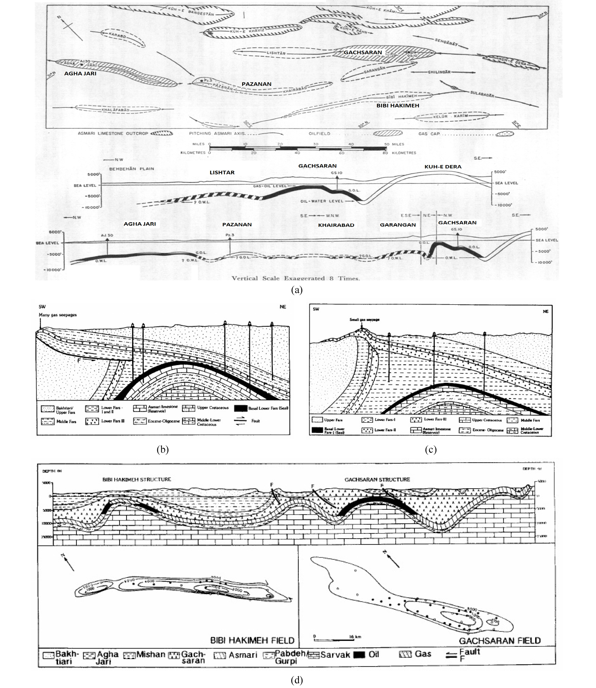
APOC (또는 AIOC, 1935년 레자 샤의 요청으로 Anglo-Iranian Oil Company로 개칭)는 1939년까지 5개의 유전(Neft-e-Shar, Gachsaran, Haft Kel, Agha Jari, Lali; Fig. 4)을 추가 발견하여 일일 생산량이 214,000배럴/일에 도달하였다가, 제2차 세계대전으로 139,000 배럴/일 수준까지 감소하였고, 종전 이후 회복하여 1950년에는 664,000 배럴/일을 생산하였다.
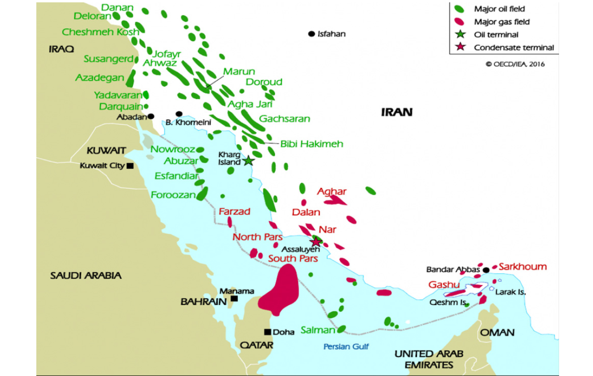
1951년 모사데그 정부가 들어서면서 유전 국유화를 단행하고, 국영석유회사(National Iranian Oil Company, NIOC)를 설립하면서, AIOC는 이란으로부터 축출되었다. 1953년 모사데그가 미국과 영국의 정보기관에 의해 기획된 쿠데타로 실각하고, 1954년 IOC들로 구성된 컨소시엄이 이란의 석유 산업을 장악하게 되는데, 지분은 British Petroleum으로 사명을 변경한 AIOC 40%, Shell 14%, Gulf Oil 8%, Com-pagnie Française des Pétroles (Total 전신) 6%, 그리고 Saudi Aramco의 파트너 회사들인 Standard Oil of California Company (Chevron 전신), Standard Oil of New Jersey (Exxon 전신), Standard Oil Co. of New York (Mobil 전신), Texaco가 각각 8%로 구성되었다. 컨소시엄은 이란의 석유 자원과 관련 설비에 대한 주권 및 소유권를 인정하고, NIOC를 대신하여 탐사, 개발, 생산 사업을 수행하며, 이익 배분은 50-50을 원칙으로 하였다. 컨소시엄은 육상에서 Ahwaz (원시매장량 279억 배럴), Marun (497억 배럴), Rag Safid (187억 배럴), Bibi Hakimeh (170억 배럴), Parsi (123억 배럴), Karanj (104억 배럴), Mansouri (210억 배럴), 해상에서 Dorood (140억 배럴), Abuzar (90억 배럴) 등의 초대형 유전들을 발견하였고, 1973년 ~600만 배럴/일 생산을 달성하여, 1979년 이슬람 혁명 전까지 비슷한 생산 수준을 유지하였다(Al-Husseini, 2007).
혁명으로 컨소시엄의 모든 계약이 무효화되고, NIOC가 독자적으로 이란의 석유산업을 이끌게 되면서, 1979년 생산이 317만 배럴/일로 떨어지고, 1980년 이라크와의 전쟁이 발발하면서 150만 배럴/일로 급감하였다. 이후 서서히 회복하여 1990년 300만 배럴/일 수준에 도달하였고, 1997년 개혁파 하타미 정권이 들어서면서 Buyback 프로젝트에 의해 IOC의 상류 부문 투자가 재개되고 생산이 꾸준히 늘어나 2004년부터 400만 배럴/일을 상회하였다(Fig. 5).

Sirri (Total/Petronas, 95,000 배럴/일 생산), Dorood (Total/Eni, 130,000 배럴/일), Darquin (Eni, 100,000 배럴/일) 유전 등이 Buyback 계약으로 개발되어 생/증산하였으며, South Pars 가스전(원시매장량 500 Tcf)의 단계별 개발‧생산 프로젝트에 Total, Eni, Statoil, CNPC, Gazprom, 우리나라의 LG, 대림산업 등이 참여하였다(https://en.wikipedia.org/wiki/Petroleum_
industry_in_Iran; https://en.wikipedia.org/wiki/National_Iranian_Oil_Company; https://en.wikipedia.org/wiki/South_
Pars_/_North_Dome_Gas-Condensate_field). 또한 NIOC는 Azadegan (원시매장량 332억 배럴), Yadavaran (170억 배럴), Ramin (74억 배럴) 등의 초대형 유전 및 South Pars를 비롯한 Kish (원시매장량 60 Tcf), Tabnak (30 Tcf), Sefid Zakhur (11 Tcf), Lavan (9.1 Tcf), Balal (8.8 Tcf) 가스전 등을 새로 발견하여 매장량을 꾸준히 늘리고 있다.
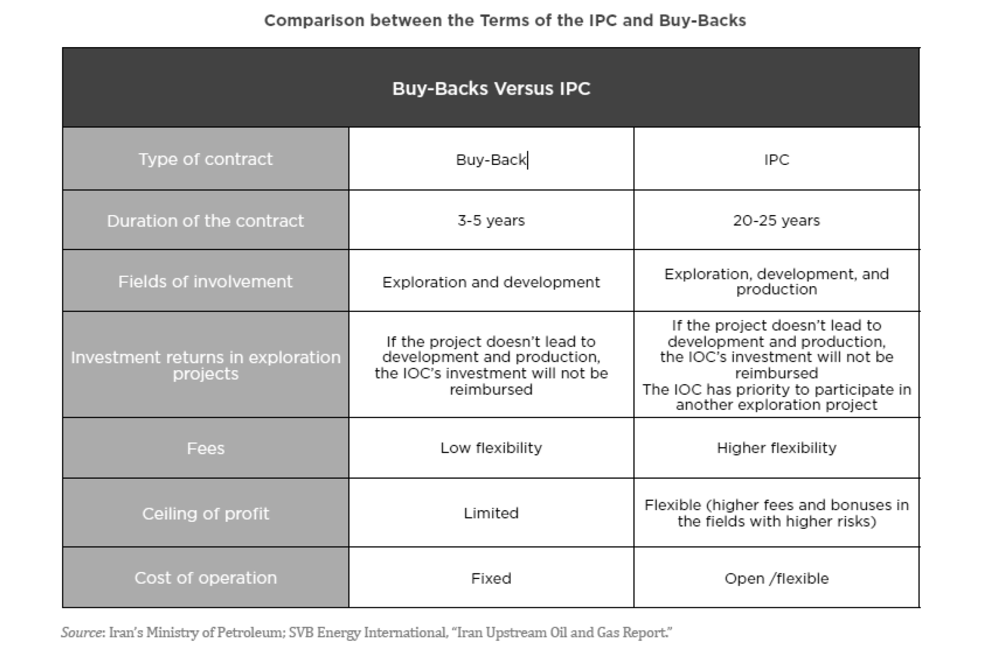
2012년 우라늄 농축으로 촉발된 경제 제재로 원유 수출이 막히면서 생산이 ~100만 배럴/일 이상 줄어들어 2013년에는 320만 배럴/일 생산하였다. 2015년 ‘이란 핵문제에 대한 포괄적 공동행동계획(JPCOA, Joint Comprehensive Plan of Action)’이 타결된 이후, 루하니 정부가 유전개발 계약 방식을 개선하고 제재로 철수했던 IOC들의 복귀와 새로운 투자를 적극적으로 추진하여, 최근 Total, Shell, Eni, 러시아의 Gazprom Neft, Rosneft, 노르웨이의 DNO, 중국의 CNPC, 일본의 INPEX, 태국의 PTTEP 등이 참여 의향을 밝히는 등 이미 어느 정도 성과를 거두고 있다. 새로운 계약 방식인 IPC는 계약 기간을 20년(+5년 회수증진)으로 크게 늘리고, IOC의 생산 단계 참여를 허용했으며, IOC와 현지 업체의 합작회사가 고정 자산에 대한 투자(Capex)와 운영 예산(Opex)을 자율적으로 결정할 수 있도록 하는 등, 이전 Buyback 방식에 비해 IOC의 독립적 유전 경영을 보장하고 비용 회수를 용이하게 하여 투자 부담을 훨씬 완화시켜 주고 있다(Nejad, 2015; Lawson and Bradstreet, 2016; Yega-nehshakib, 2016; Oil & Gas 360, 2015)(Fig. 6). IPC 프로젝트는 기 발견 유전(green field)의 개발‧생산 사업, 기 생산 유전(brown field)의 개량 및 회수 증진 사업, 신규 광구의 탐사 사업, 하류 부문 사업 등으로 구성된다(Fig. 7). IPC 개발‧생산 프로젝트에 포함된 52개 유‧가스전의 원시매장량은 석유 3,910억 배럴, 가스 255 Tcf에 달하는데, South Pars, Salman, Foroozan 등 주변국과 저류층을 공유하는 국경 부근의 23개 유‧가스전의 개발이 우선적으로 추진되며, South Azadegan, Changuleh, Darquain 3단계 등 신속한 개발이 가능한 green field 유전, Ahwaz, Mansuri 등 회수증진이 필요한 brown field 유전을 망라한다(http://ipc.nioc.ir/Portal/). NIOC는 IPC 프로젝트를 통해 100만 배럴/일을 증산하여 2020년까지 570만 배럴/일 생산을 목표로 하고 있는데, 주변국과 인접한 유전에서 15만 배럴/일, green field 유전에서 55만 배럴/일, 회수증진 30만 배럴/일의 생/증산을 기대하고 있다(Nejad, 2015; NIOC’s IPC portal site http://ipc.nioc.ir/Portal/Home/).
지체 구조
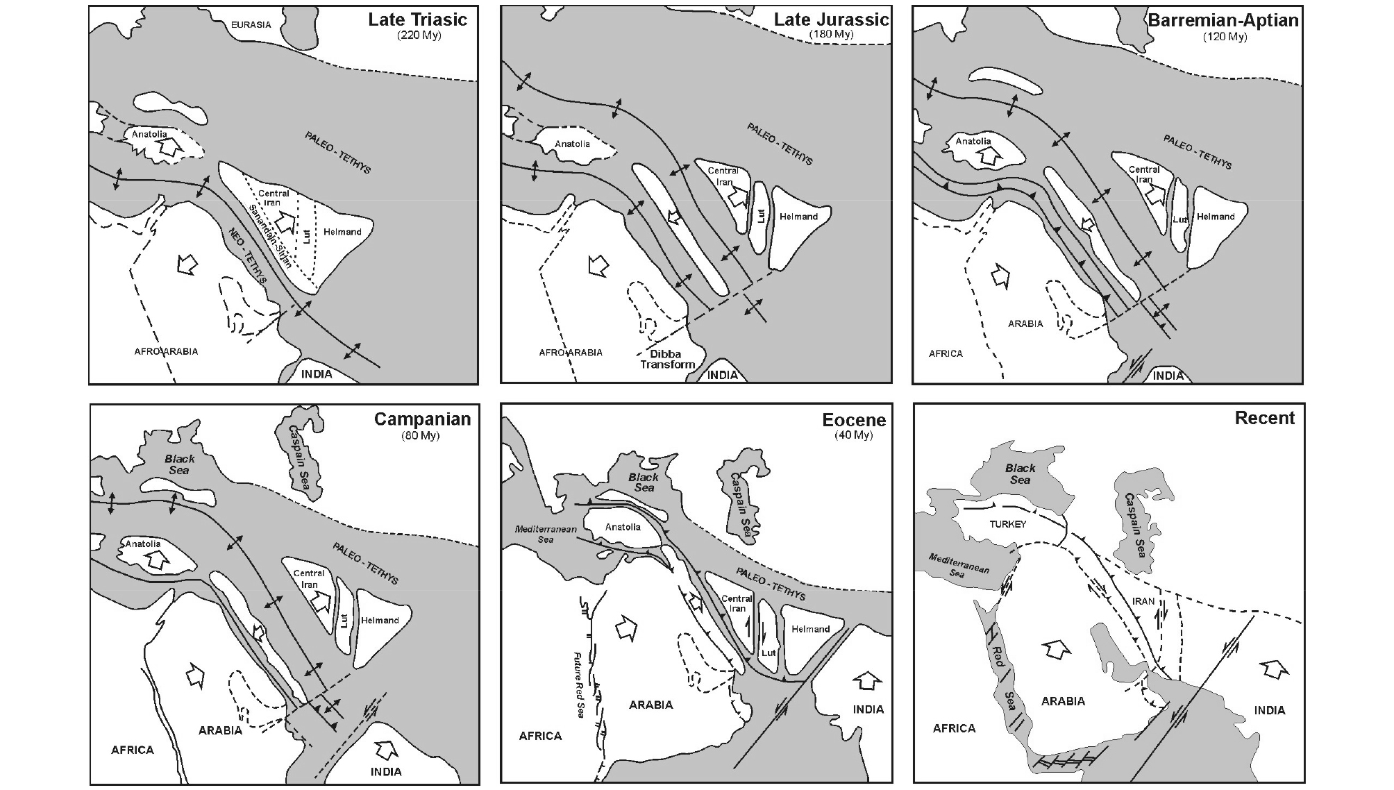
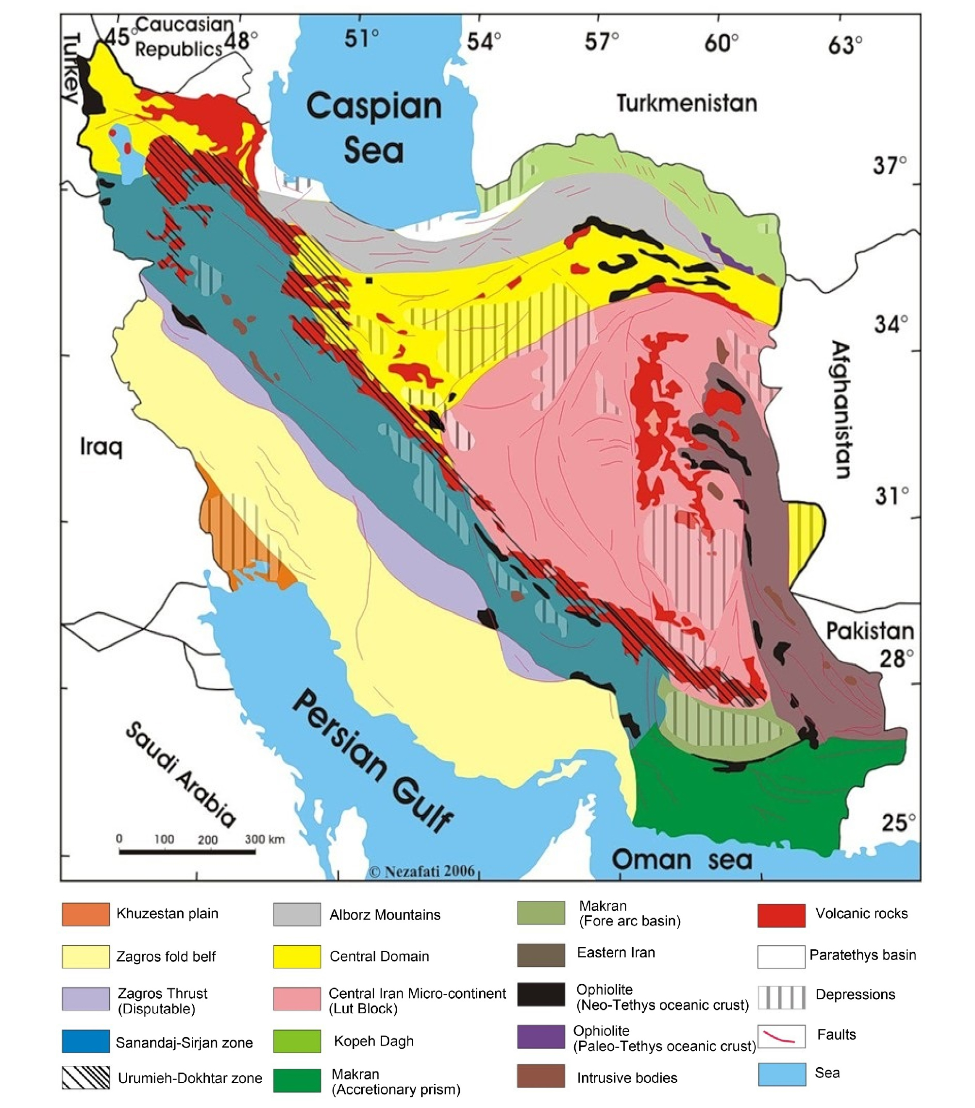
이란의 지체 구조는 아라비아 판과 유라시아 판이 고 테티스(Paleo-Tethys) 대양과 신 테티스(Neo-Tethys) 대양의 소멸로 충돌하면서, 습곡과 스러스트, 화산 활동, 오피올라이트(ophiolite) 압등을 포함한 지질 작용으로 알보르즈 및 자그로스 산맥이 솟아오르고, 이란 육괴가 합체하여 형성되었다(Fig. 8). 이란의 지체 구조 단위는 Central Iranian Block을 중심으로, 북서-남동 방향으로 평행하게 발달한 남서부의 Zagros Zone, Sanandaj-Sirjan Zone, Urumieh-Dokhtar Magmatic Arc, 북쪽으로 Alborz Zone과 Turan 지체에 속하는 Kopeh Dagh Zone, 남쪽으로 오만 해의 섭입 복합체로 이루어진 Makran Zone, 동쪽으로 플리시(flysch), 멜란지(melange)와 오피올라이트로 이란 육괴와 아프간 육괴 사이를 봉합(suture)하는 Eastern Iran Zone(또는 Zabol-Baluch Zone, Sistan Suture) 등으로 구성된다(Fig. 9)(Stocklin, 1968; Berberian and King, 1981; Ghorbani, 2013; http://gsi.ir/en/contents/0022/Geology.of.Iran.html).
Central Iranian Block (CIB, 이란 중앙 육괴)은 고생대 후기 신 테티스 대양으로 분리되기 이전까지 곤드와나 초대륙을 구성하는 아라비아 대지와 지구조, 층서, 연해 환경(epicontinental sea)의 퇴적 특성, 퇴적상 및 퇴적환경을 공유한다(Fig. 10). 아라비아 대지에 널리 분포하는 선캄브리아기 말(Infra- 또는 Eocambrian) 암염 층(Hormuz Salt)이 CIB에도 분포하며(Husseini and Husseini, 1990), 아라비아 대지에 결부된 천해 또는 육상 환경에서 퇴적된 탄산염암과 쇄설암이 고생대 층서를 구성하고 있다(Fig. 11(a), (b)). CIB는 아라비아 대지와 떨어져 북쪽으로 이동하면서(Takin, 1972; Glennie, 1992) 달라진 층서 진화를 보이는데, 특히 쥐라기부터는 쇄설성 퇴적이 주류를 이루어 아라비아 대지의 탄산염암 퇴적과 확연히 구별된다(Fig. 11(c))(Berberian and King, 1981; Wilmsen et al., 2009). CIB의 핵심을 이루는 루트(Lut), 타바스(Tabas), 야즈드(Yazd) 블록들은 지괴 단층 운동(block faulting)으로 지구-지루(graben-horst) 구조를 보이며, 대 카비르(Great Kavir), 나인-바프트(Nain-Baft), 네반단(Nehbandan) 등의 대 단층들에 의해 주변과 구분된다. CIB 북부는 알보르즈 전면, 콤(Qom), 대 카비르 분지 등 신생대 분지가 발달해 있는데(Fig. 16 참조), 탄산염암, 증발암 및 주변 조산대로부터 유입된 쇄설성 퇴적물이 각각 7.5, 12, 5 km 두께로 채우고 있다(Jiménez-Munt et al., 2012; Morley et al., 2009). CIB 남서부는 신 테티스 대양의 섭입으로 형성된 화산대(Urumieh-Dokhtar Arc)가 자그로스 조산대에 평행하게 발달해 있다(Fig. 11(d)).
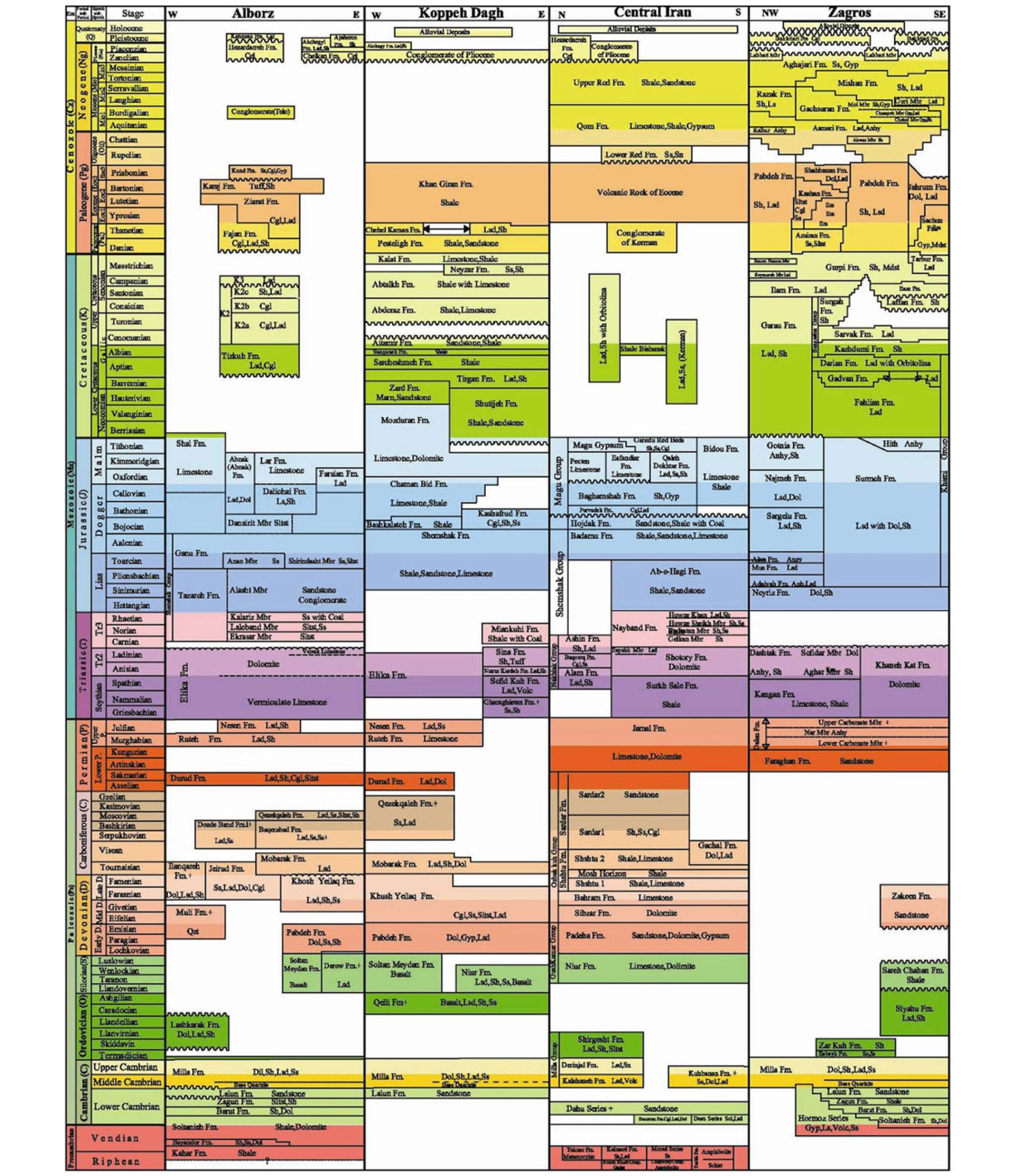
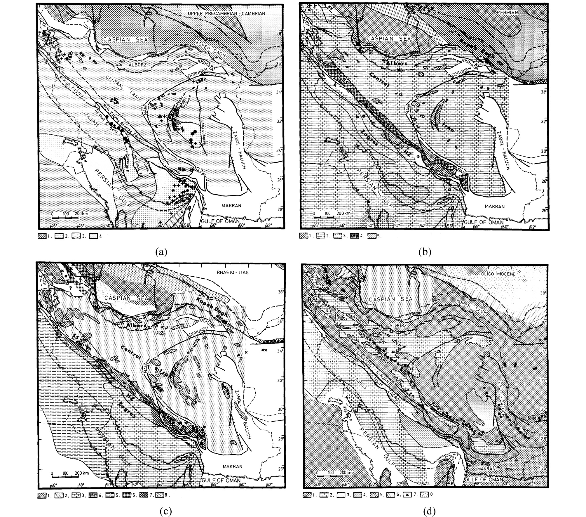
Fig. 11.
Paleogeographic maps of Iran (Berberian and King, 1981). (a) Late Precambrian~Cambrian. 1. Basement highs, 2. Hormuz salt basins, 3. Upper Precambrian~Cambrian clastics and carbonates (Soltanieh, Lalun, Zaigun Formations), 4. Eurasian domain. (b) Permian. 1. Basement highs, 2. Transgressive basal sandstones (Dorud Formation in Central and northern Iran, Faraghan Formation in Zagros), together with the main marine carbonates (Dalan Formation in Zagros, Ruteh and Nessen Limestone Formation in Central and northwestern Iran, Jamal Formation in eastern Iran), 3. Nar Evaporite Member of the Dalan Formation, 4. Alkaline basalt, diabases and flysch sediments in the Sanandaj-Sirjan Zone, 5. Eurasian domain. (c) Late Triassic~Jurassic, 1. High areas of erosion or no sedimentation, 2. Continental paralic sandstone and shale with coal seams in Central Iran, Alborz and Kopeh Dagh, 3. Middle to Upper Jurassic marine carbonates of the Surmeh Formation with thin shallow water shaly unit of the Neyriz Formation at the base, 4. Mainly carbonates and shale in the northwestern segment of the High Zagros. 5. Mainly shale and anhydrite with minor carbonates in west Zagros, 7. Jurassic oceanic sediments, mainly radiolarite along the High Zagros, 8. Eurasian domain. (d) Oligocene~Miocene. 1. Mountainous region, and areas of erosion and non-marine sedimentation, 2. Marine Carbonates (Asmari Formation in Zagros, Qom Formation in Central Iran), 3. Continental littoral sandstone (Ahwaz delta), 4. Continental red beds in Central Iran and Razak red silty marls with subordinate silty limestone and sandstone in Zagros, 5. Flysch-molasse sediment, 6. Malasse (Maikop Series composed of conglomerate, clay and tuffaceous sandstone in northeastern Iran, 7. Igneous rocks in Central Iran, Zabol-Baluch, and south Afghanistan, 8. Turan Platform.
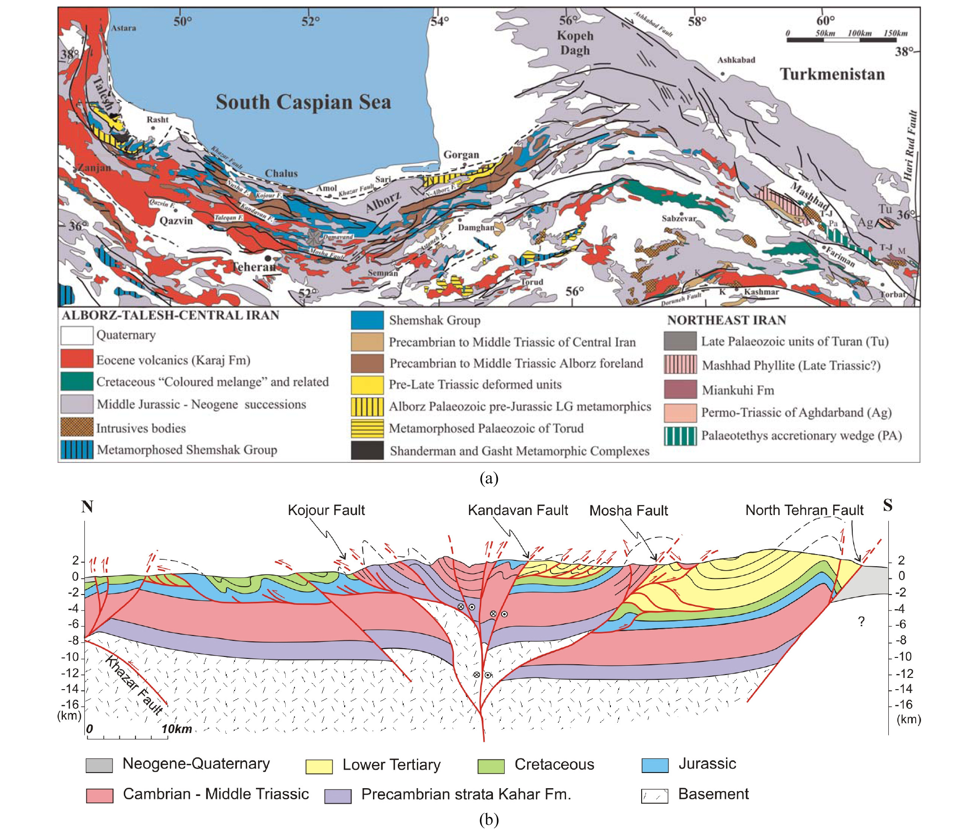
Alborz Zone (AZ, 알보르즈 구조대)은 카스피 해 남쪽 해안을 따라 동서 방향으로 평행한 스러스트-습곡대로 알프스-히말라야 조산대의 북쪽 축에 속한다(Fig. 12). 알보르즈는 선캄브리아기~트라이아스기 중기 동안 안정된 지괴에서 탄산염암과 쇄설암이 ~6 km 두께로 쌓이고, 트라이아스기 후기 고 테티스 대양이 소멸되면서 유라시아 판과 이란 육괴를 포함한 킴메리아(Cimmeria) 판의 충돌로 결층된 이후, 쥐라기 전기 하상 및 삼각주상의 쇄설암과 쥐라기 중기~백악기 탄산염암의 퇴적으로 이어지는 등, CIB와 층서적으로 매우 유사하다(Stocklin, 1968; Berberian and King, 1981). 알보르즈 구조의 대부분은 신생대 아라비아 판과의 충돌에 따른 원격 횡압력(far-field transpression)으로 형성되었으며(Allen et al., 2003; Allen, 2010), 트라이아스기 킴메리아 구조 운동의 흔적은 미미하다.
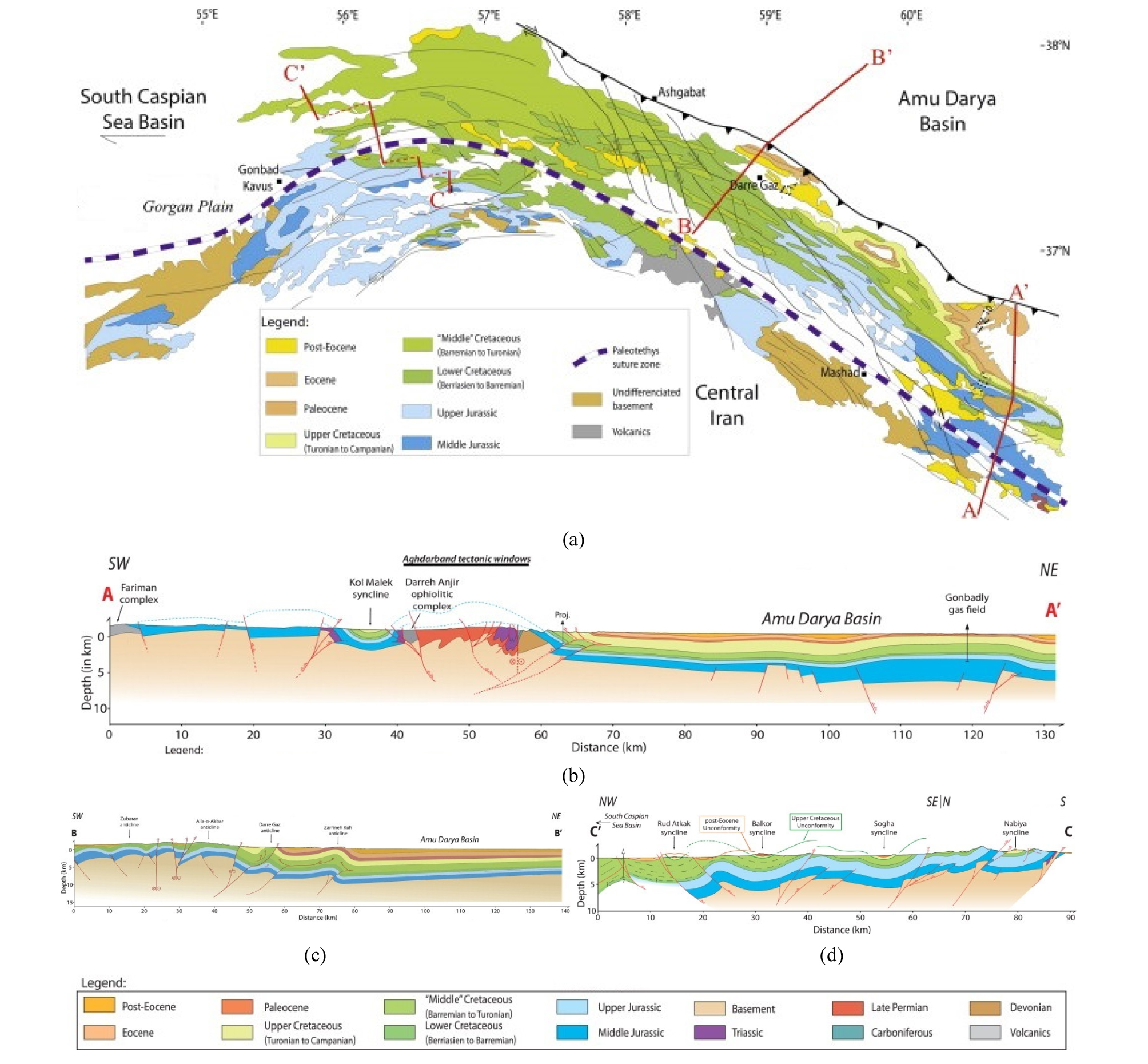
Kopeh Dagh Zone (KDZ, 코페다그 구조대)은 킴메리아 구조 운동 이후 유라시아 판의 안정된 육괴를 구성하는 튜란 대지에서 퇴적된 두께 7 km 이상의 쥐라기 중기~에오세 탄산염암 및 쇄설암이 아라비아 판과의 충돌 여파로 현재도 구조적 변형과 강진을 겪고 있는 신생 스러스트-습곡대이다(Robert et al., 2014)(Fig. 13). KDZ는 자그로스 분지 다음으로 중요한 석유 지역으로 Khangiran (확인매장량 17 Tcf), Gonbadli 등의 대형 가스전이 발견되었다.
Makran Zone (MZ, 마크란 구조대)은 오만 해가 섭입하는 해구(trench)와 전호(forearc) 분지 사이에 있는 신생대 부가체(accretionary prism or wedge)로, 융기하여 해안선에 평행하게 동서 방향으로 해발 ~1,500 m의 산계를 형성하고 있다. MZ는 자그로스 구조대와 미납(Minab) 변환 단층에 의해 경계하고, 전호 분지에 해당하는 북쪽의 자스무리안(Jas Murian) 분지와 백악기~팔레오세 오피올라이트 파쇄대(melanged ophiolite)에 의해 구분되며, 동쪽으로 파키스탄의 차만(Chaman) 변환 단층까지 연장된다(McCall, 2002; Burg et al., 2013)(Fig. 14). 마크란 부가체는 폭이 300~350 km에 달하며, 남으로 경사하는 역단층들에 의해 인편(imbricate) 구조가 발달하고, 좁은 곡분을 저탁류 플리시가 채우는데, 북쪽에서 남쪽으로 변형 정도가 약해지고, 수심이 얕아지며, 퇴적 시기도 늦어져서 에오세~마이오세 전기 해저사태(olistostrome) 및 플리시 퇴적층, 올리고세~마이오세 해저사면 퇴적층, 마이오세 후기~플라이스토세 천해 및 육상 퇴적층이 차례로 분포한다.
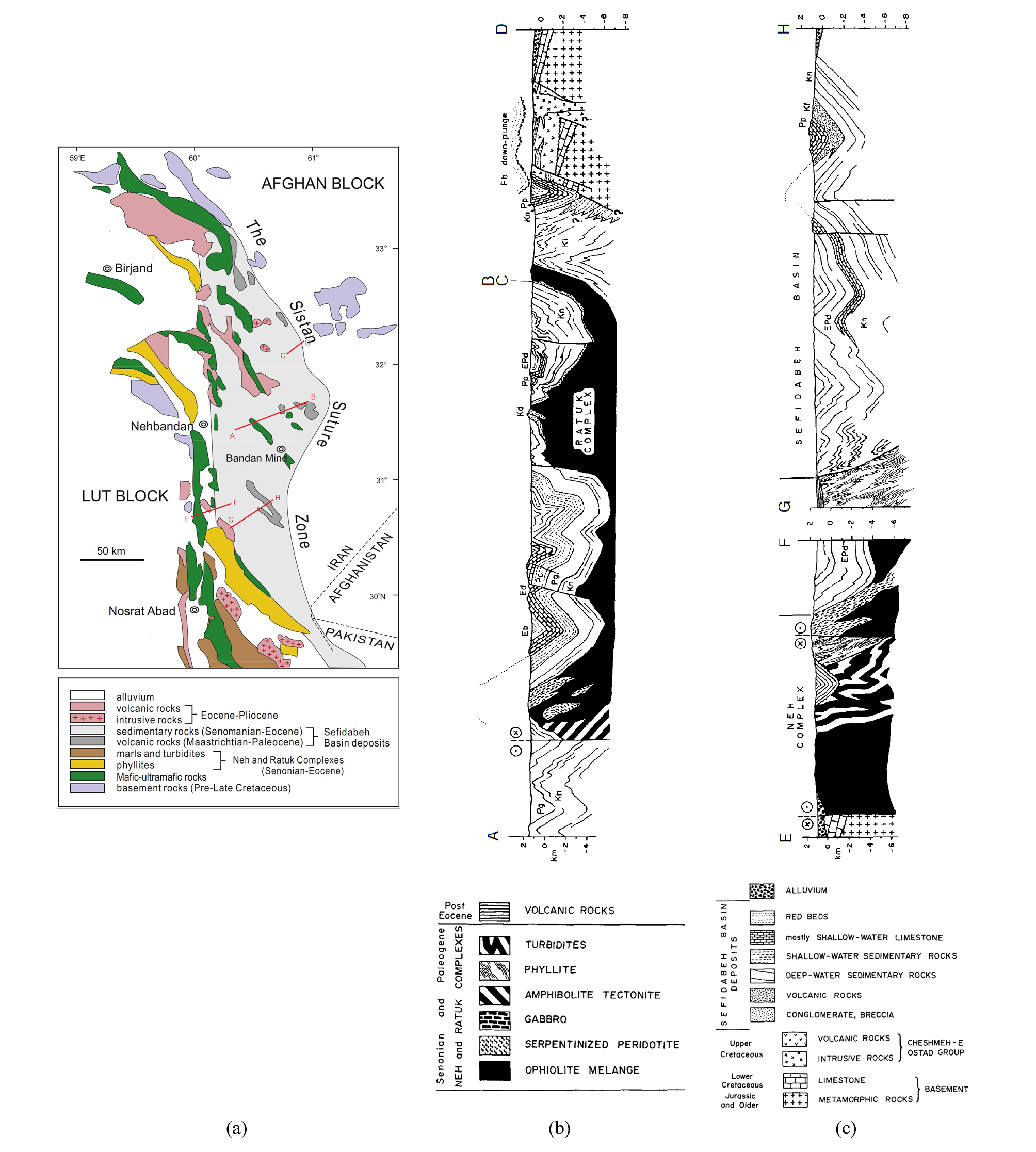
Eastern Iran Zone (EIZ, 이란 동부 구조대)은 이란과 아프가니스탄 국경 부근 해발 고도 2,000~3,000 m의 이란 동부산맥(Eastern Iranian Ranges)을 구성하는 남북 방향의 백악기~신생대 오피올라이트 복합체와 전호 분지로 해석되는 상부(Sefidabeh 분지)를 채우는 퇴적체로 이루어진 구조대이다(Tirrul et al., 1983)(Fig. 15). 오피올라이트 복합체는 아프가니스탄 방향으로 섭입했던 것으로 추정되는 해양 지각의 조각, 고압-저온성 변성암. 플리시 기원의 천매암 등이 뒤섞인 멜란지이며, 세피다베 분지는 수차례의 구조적 변형으로 습곡과 단층이 발달한 ~5 km 두께의 백악기 말~에오세(71~49 Ma) 저탁류 쇄설암, 이회암, 칼크-알칼리질 화산암, 탄산염암 등이 구성한다.
Zagros Zone (ZZ, 자그로스 구조대)은 신 테티스 대양이 소멸하고 아라비아 대지 판과 CIB를 포함하는 유라시아 판이 충돌하면서 형성된 스러스트-습곡대로, 이란 대부분의 유전이 분포하는 이 논문의 핵심적인 지체 구조 단위이다(Stocklin, 1968; Berberian and King, 1981; Bordenave, 2014). ZZ는 아라비아 대지(Platform; 구조 운동과 변성 작용을 거의 받지 않은 육성 또는 천해성의 비교적 평탄한 퇴적 층서로 덮인 대륙 지괴)와 Main Zagros Fault (MZF, 자그로스 주단층; 유라시아 판과 아라비아 판의 경계) 사이에 있는 구조대로, 스러스트대(High Zagros, Zagros Thrust, Zagros Crushed or Imbricated zone, HZ)와 단순 습곡대(Simply Folded Belt, SFB)로 구성된다(Fig. 16). HZ는 북동으로 경사하는 스러스트 블록들이 기왓장처럼 포개져 있으며, High Zagros Fault (HZF, 자그로스 고단층)에 의해 구분되는 SFB는 기반암 상부에 놓인 8~11 km에 달하는 선캄브리아기~플라이오세 퇴적암이 습곡으로 거대한 배사와 향사 군을 형성하고 있다. 이들의 지질, 구조 및 층서 등에 대한 구체적인 내용은 본론에서 집중적으로 다루어진다.
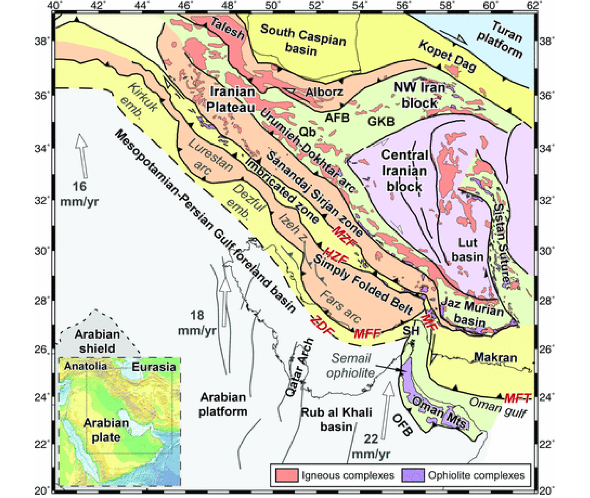
Fig. 16.
Main tectonic elements of the Zagros and adjacent zones (Jiménez-Munt et al., 2012). ZDF; Zagros deformation front, MFF; Mountain front fault, HZF; High Zagros fault, MZF; Main Zagros fault, MF; Minab fault, MFT; Makran frontal thrust, Qb; Qom basin, GKB; Great Kabir basin, AFB; Alborz foredeep basin, OFB; Oman foreland basin, SH; Strait of Hormuz. White arrow represents the relative velocities of the Arabian plate with respect to a fixed Eurasian plate.
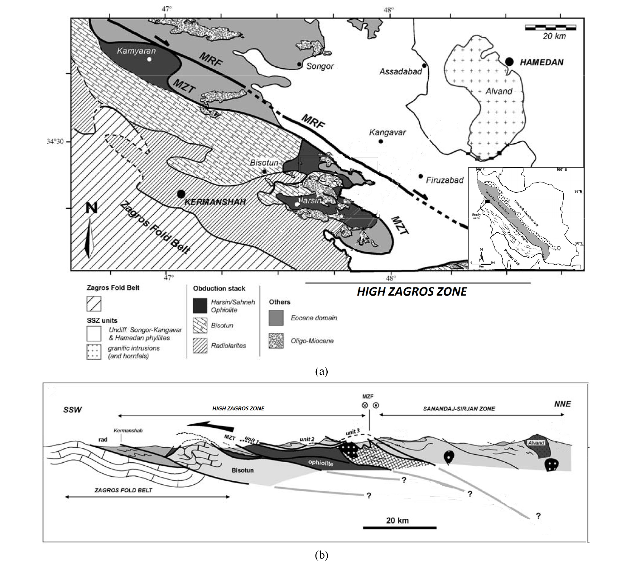
Sanandaj-Sirjan Zone (SSZ, 사난다즈-시르잔 구조대)은 ZZ에 평행하게 북서-남동 방향으로 폭 ~200 km, 길이 ~1,500 km 연장하는 변성암대로, 단층과 습곡, 화강암 관입 등으로 복잡하게 뒤얽히고, 신생대 퇴적층에 의해 널리 덮여 있어, ZZ 및 CIB와의 연계가 확실치 않다. SSZ는 스러스트 등 구조 양상이 ZZ와 유사하여 아라비아 판의 일원으로서 충돌대(collisional orogen)에 편입시키거나(Alavi, 1994), 층서, 부정합, 화성 활동 및 구조적 변동 등의 지사적 측면이 CIB와 비슷하여 유라시아 판을 구성했던 킴메리아 판의 일부로 간주된다(Stocklin, 1968; Agard et al., 2011; http://gsi.ir/en/contents/0022/Geo
logy.of.Iran.html). SSZ를 구성하는 각섬암, 편암, 천매암, 메타탄산염암(metacarbonate), 메타화산암(metavolcanic)은 고생대~쥐라기 퇴적암 및 화산암의 변성으로 해석되고, 화강암은 신 테티스 대양의 섭입으로 시작된 안데스 형 경계부에서의 화성 활동의 결과로 관입 시기는 트라이아스기로부터 백악기 후기이며 쥐라기에 가장 활발하였다(Berberian and Berberian, 1981; Agard et al., 2011; Mohajjel and Fergusson, 2014; Hassanzadeh and Wernicke, 2016).
Urumieh-Dokhtar Magmatic Arc (UDMA, 우르미에-도흐타르 화산대)는 SSZ와 CIB 사이에서 ZZ와 평행하게 능선을 형성하는 폭 ~150 km의 화산암대로, 에오세에 집중된 막대한 양의 화산암 분출과 화산쇄설암 퇴적으로 형성되었으며, 두께는 5 km 이상이다. UDMA는 SSZ와 단층 또는 단층대로 추정되는 호수가 발달한 저지대에 의해 구분되고 같은 시기의 화산암이 CIB 주변부 및 Lut 블록, AZ, EIZ에도 널리 분포하는데, 섭입대의 갑작스러운 이동(jump) 또는 섭입각의 변화에 따른 화산호의 동진(Azizi and Moine-vaziri, 2009), 신 테티스 대양 소멸 이후 잔존 또는 해체된 해양 지각에 의한 화산 활동의 결과(cf. 티벳, Chung et al., 2005) 등으로 설명된다.
Ophiolite Terrane (OT, 오피올라이트 지대)은 고 테티스 또는 신 테티스 대양에 의해 분리되었던 지체 단위들이 봉합되는 과정에서 압등한 해양 지각과 상부의 퇴적물, 저온 고압 변성암, 멜란지 및 플리시 등이 섞여 경계를 구획하는 독특한 지대로, 호이(Khoy), 케르만샤-네이리즈(Kerman-shah-Neyriz), 나인-바프트(Nain-Baft), 사브제바르(Sabze-var), MZ 북부, EIZ 서부 등에 분포한다(Fig. 17). OT의 지질 시대는 고생대와 중생대로 나뉘는데, 고생대 OT는 데본기~페름기의 고 테티스 대양으로부터 유래하였으며, 북부 지역 라슈트(Rasht), 마슈하드(Mashhad) 등 유라시아 판의 튜란 블록과 AZ 또는 CIB 사이에 위치하고, 중생대 OT는 대부분 백악기 후기의 신 테티스 대양 또는 대양의 분기, 배호 및 전호로부터 유래하였으며, ZZ와 SSZ, SSZ와 CIB, CIB와 아프간 블록, CIB와 MZ 사이에 산재한다(Delaloye and Desmons, 1980; Moghadam et al., 2013; Moghadam and Stern, 2014, 2015).
자그로스의 지질
자그로스는 전형적인 스러스트-습곡대와 전면 분지의 조합으로 이루어진 석유 지역으로, 140여개의 유‧가스전이 발견되었으며, 석유, 컨덴세이트, 가스의 원시부존량이 각각 6,000억 배럴, 320억 배럴, >1,000 Tcf에 달한다(Esrafili-Dizali and Harchegani, 2012; Al-Husseini, 2007; Cooper, 2007)(Fig. 18).
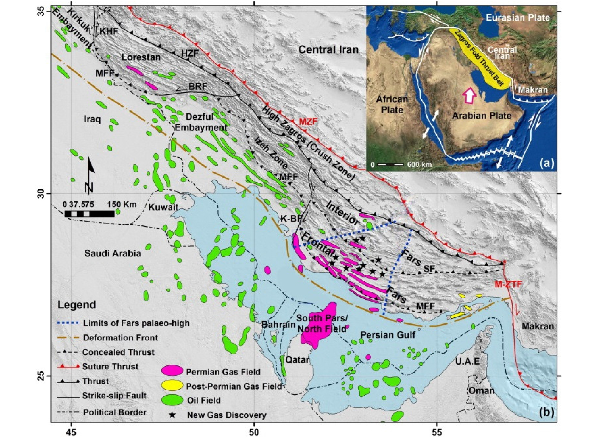
Fig. 18.
(a) Index map, (b) Distribution of oil and gas fields in relation to morpho-tectonic structures of the Zagros fold-thrust belt (Najafi et al., 2014). MZF; Main Zagros fault, HZF; High Zagros fault. MFF; Mountain front fault, KHF; Khaneqein fault, BRF; Balarud fault, K-BF; Kazerun-Borazjan Fault, SF; Surmeh fault, M-ZTF; Minab-Zendan transfer fault.
자그로스는 선캄브리아기~중생대 동안 아라비아 판의 연안대(epicontinent)와 테티스 해와의 수동형 대륙경계부였으며, 백악기 후기~신생대 동안 유라시아 판과의 통시적(diachronous) 충돌로 전진하는 조산대와 그 전면에 위치하였다. 지속적인 퇴적과 습곡 및 단층에 의한 압축 및 중첩으로 퇴적층의 두께가 7~14 km에 달하며, 선캄브리아기 증발암(1~2 km), 고생대 쇄설암(~2 km), 페름기~중생대 탄산염암(3~4 km), 백악기 후기~올리고세 이회암, 셰일 및 탄산염암(~1 km), 마이오세 증발암 및 쇄설암(5~6 km), 플라이오세~플라이스토세 역암 등으로 구성된다(Stocklin, 1969; Alavi, 2004, 2007; Agard et al., 2011)(Fig. 19).
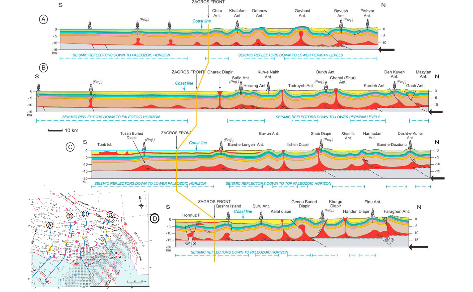
자그로스는 전면 분지(FB), 습곡대(SFB), 스러스트대(HZ)로 구성되고, 이들 구조 단위들은 Zagros Deformation Front (ZDF, 자그로스 변형 전단), Mountain Front Fault (MFF, 자그로스 전면 단층), HZF, MZF 등의 스러스트 단층들에 의해 구분된다(Fig. 20)(Berberian, 1995; Falcon, 1974). ZDF는 최전방에 위치한 심부의 스러스트에 의해 아라비아 대지의 연장선 상에 있는 비변형대와 ZZ를 구분하고, 충적층으로 덮여서 지표에 노출되지는 않으나 낮은 수준의 지형적인 단락을 형성한다. MFF는 전면 분지와 자그로스의 전형적인 대규모 향‧배사가 발달한 단순 습곡대(SFB)를 구분하는데, ZZ를 MFF가 궁형으로 전진해 있는 파르스(Fars)와 루레스탄(Lurestan 또는 Lorestan) 돌출부(Arc)와, 카제룬(Kazerun), 발라루드(Balarud), 카나킨(Kha-naqin) 등 주향이동 단층을 사이에 두고 MFF가 오목하게 들어간 데즈풀(Dezful)과 키르쿠크(Kirkuk) 만입부(Embay-ment)로 나눈다(Figs. 16, 18). MFF는 파르스와 루레스탄에서는 500 m 등고선을 따르고, 데즈풀에서는 1,000 m 등고선을 따라 단애를 형성하며, 전방을 마이오세 Gachsaran 증발암과 Aghajari, Bakhtiari 등 마이오세 후기~플라이스토세 몰라세 퇴적층이 쐐기 형태로 채우고, 후방은 올리고세 Asmari 및 백악기 Bangestan 탄산염암 층을 핵심으로 한 고래등 모양의 배사(pericline)들이 특색있는 지형을 형성한다. HZF는 자그로스에서 가장 높이 솟은 스러스트대(High Zagros)와 SFB를 구분하며, 수직적 변위가 >6 km에 이르는 단층으로 심부의 고생대 및 중생대 전기 퇴적층을 지상으로 끌어올려 노출시키고 있다. MZF는 자그로스(ZZ)와 사난다즈-시르잔(SSZ) 구조대 사이를 가르며 아라비아 판과 유라시아 판의 경계를 형성한다. MZF는 현재는 비활성의 역단층 구간인 Main Zagros Reverse Fault (자그로스 역단층)와 지진이 빈발하고 활동적인 주향이동 구간인 Main Recent Fault (자그로스 현세 단층)로 구성되어 대륙간 충돌로 인한 변형을 분담(strain partitioning)하고 있다(Blanc et al., 2003).
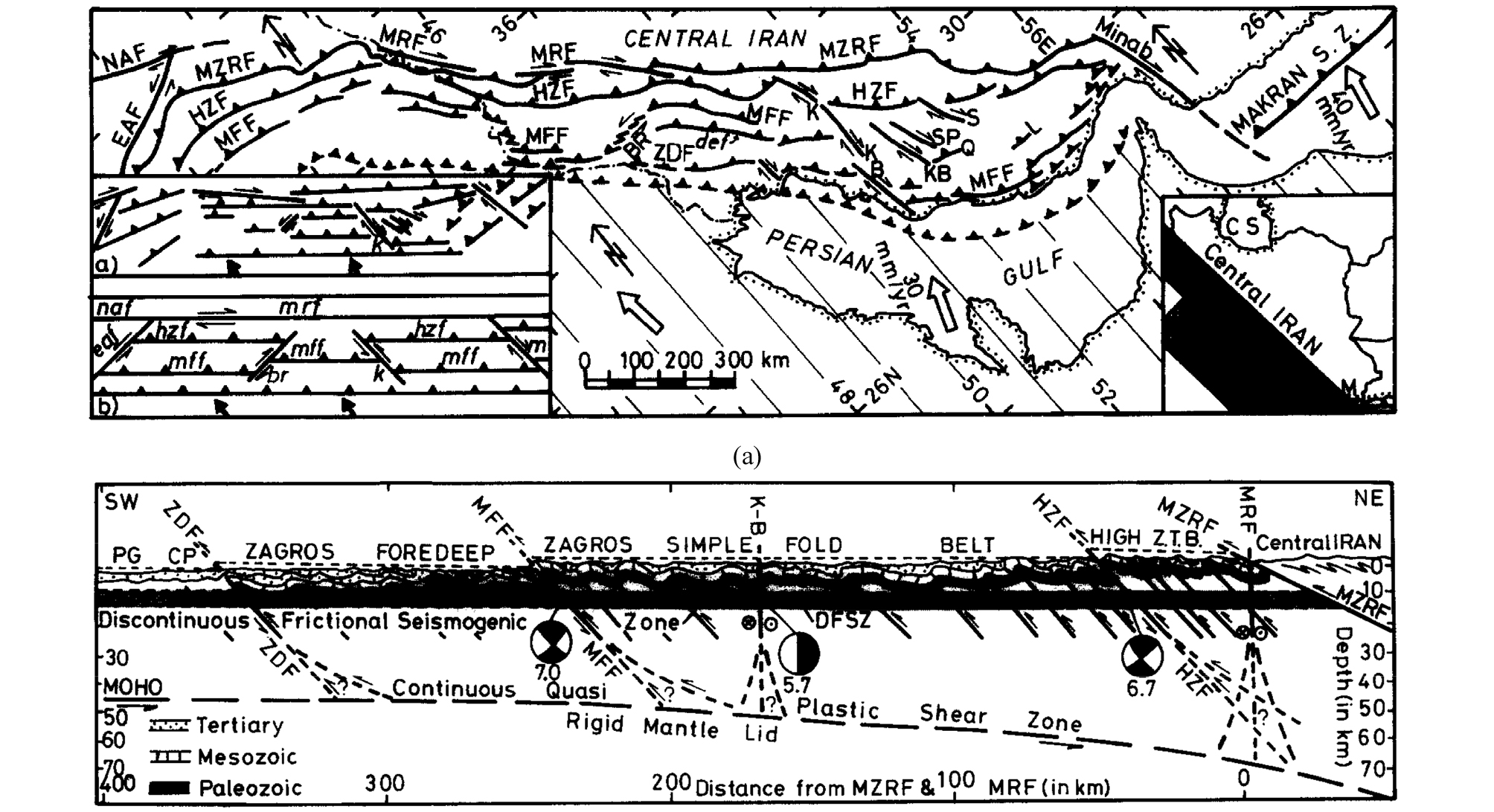
Fig. 20.
Major morpho-tectonic features and units of the Zagros fold-thrust belt (Berberian, 1995). (a) Main fault systems of the Zagros belt, MRF; Main Resent fault, NAF; North Anatolian fault, MZRF; Main Zagros reverse fault, HZF; High Zagros fault, MFF; Mountain front fault, ZDF; Zagros deformation front, : Major longitudinal strike-slip faults; K-Kazerun fault, B-Borazjan fault, KB-Kareh Bas fault, S-Sarvestan fault, SP-Sabz Pushan fault, BR-Balarud fault, EAF-East Anatolian fault: Makran S.Z.-Makran subduction zone. Inset a) simplifies the deformation in the Zagros. Inset b) illustrates partitioning of the oblique convergence between Arabia and Eurasia into thrusting and right-lateral strike-slip motion along the MRF. (b) Subdivisions of the Zagros belt in relation to the main fault systems, High Z.T.B.; High Zagros Thrust Belt, K-B; Kazerun-Borazjan fault, PG; Persian Gulf, CP; Coastal Plain.
자그로스 전면 분지는 이란 석유의 대부분이 부존하는 데즈풀 만입부(Dezful Embayment, DE)를 비롯하여, 현생의 메소포타미아 저지대 및 페르시아 만을 포함한다. DE는 SFB의 습곡과 스러스트가 지하로 연장하여 산자락(foothill)을 형성하며 연안 평원으로 이어지는 사이에 위치하는데, 압축과 퇴적이 지속적으로 진행되고 Gachsaran 증발암이 미끄럼대(decollement)로 작용하면서 Asmari 층 하부와 부조화된(disharmonic) 습곡이 발달한다(Fig. 21). DE는 Asmari 이후 퇴적층의 두께가 MFF에 인접한 퇴적 중심부에서 6 km 이상이고 남쪽으로 얇아지면서, 스러스트 대의 지구조적 하중으로 휘어져 침강(flexural subsidence)하는 전면 분지의 전형적인 단면을 보인다(Pirouz et al., 2011; Sepehr and Cosgrove, 2004; Fard et al., 2006).
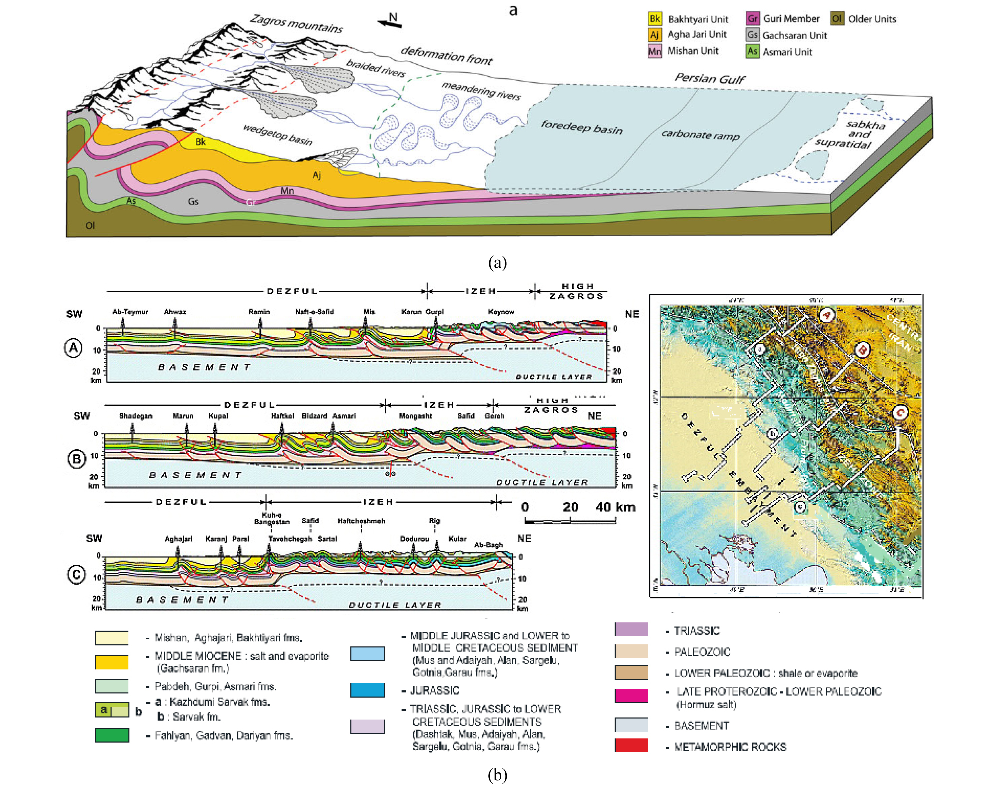
단순 습곡대는 이름과 달리 습곡과 스러스트가 밀접하게 결합되어 있는 구조대이다. SFB에는 북서-남동 방향의 습곡들이 안행으로 분포하는데, 습곡된 층의 두께가 변하지 않고 비교적 일정한 평행 습곡이고, 축면이 북동으로 기울어져 남서 방향으로 전도하는 비대칭형 경사 습곡이다(Figs. 21, 23)(Coleman-Sadd, 1978; Sattarzadeh et al., 2000). SFB의 습곡은 진폭이 2~3 km이고, 파장은 10~20 km이며, 배사축의 길이가 5~120 km이다(Talbot and Alavi, 1996; Sattarzadeh et al., 2002; Burberry et al., 2010)(Fig. 22(a)). 습곡의 크기를 결정하는 진폭과 파장은 습곡에 수반되는 층, 특히 탄산염암과 같은 단단한 층의 두께와 응력의 크기에 좌우되며, 습곡을 구성하는 층들의 유변성(rheology), 기반암의 거동(thin-skinned/thick-skinned), 하부 호르무즈 암염층의 유무 등이 주요 변수로 작용한다(Coleman-Sadd, 1978; Bahroudi and Koyi, 2003; Mouthereau et al., 2007a, b).
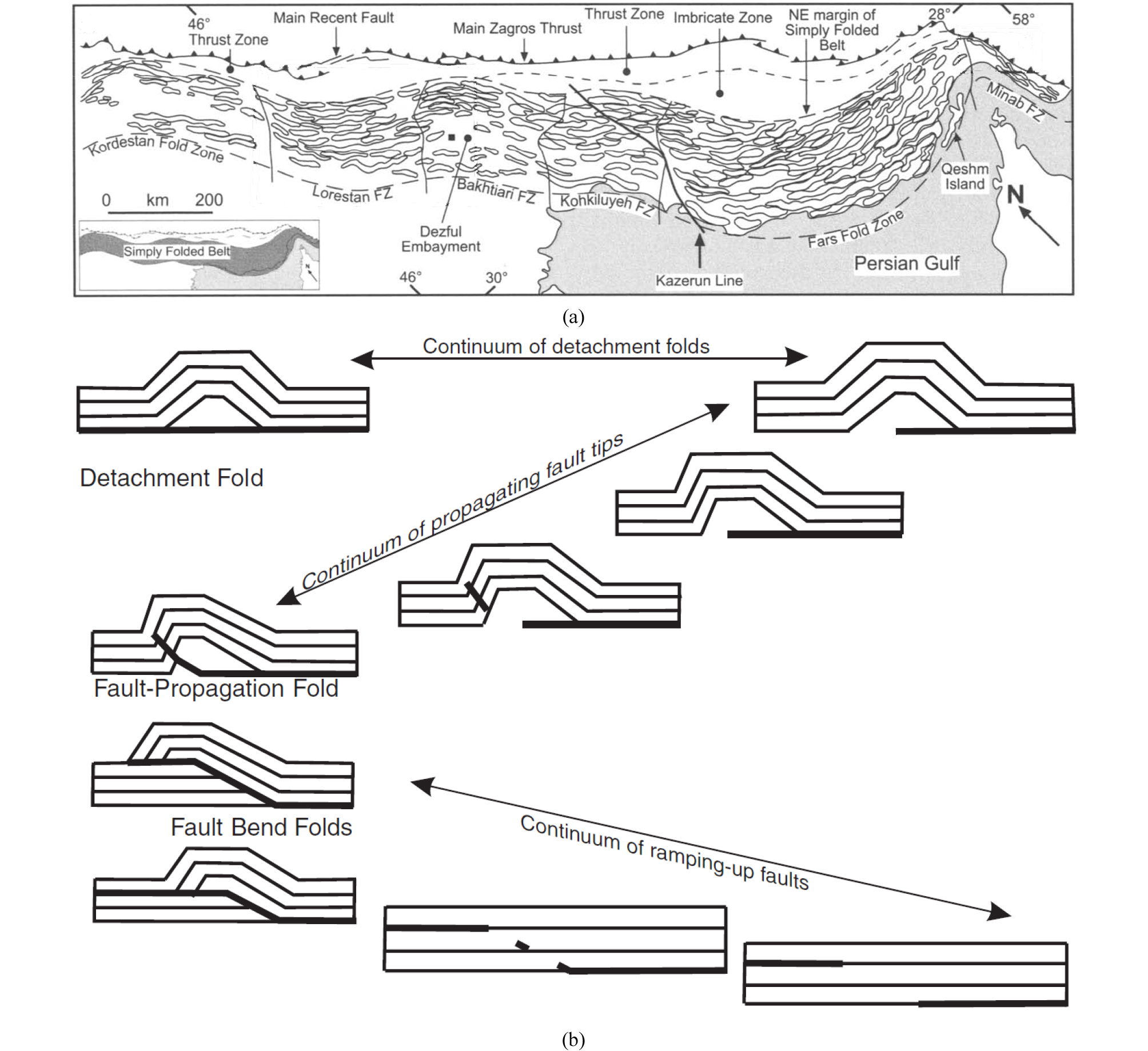
SFB의 습곡은 성층면에 평행하게 작용하는 횡압력에 의해 형성되는 좌굴 습곡(buckle fold)과 성층면에 고각으로 작용하는 힘에 의해 굽힘(bend)으로 형성되는 강제 습곡(forced fold)으로 구성된다(Mouthereau et al., 2012). 좌굴에 의한 평행 습곡은 성층면에서의 굴곡 슬립(flexural slip)과 중립면을 중심으로 한 팽창과 수축으로 변형의 균형이 유지되는 작용(neutral surface folding)으로 형성되는데, 평행한 동심 습곡이 위 또는 아래로 무제한 연속될 수 없는 태생적인 공간적 문제를 갖는다(Coleman-Sadd, 1978). 강제 습곡은 하부에 박리 스러스트 단층(detachment thrust fault 또는 decollement)이 발달하면서 상부의 층들을 들어 올리고 굽히게 하여 형성되는데, 기반암과 분리되면서 좌굴을 수반한 단층과 연계된 분리 습곡(detachment fold), 단층이 상부로 전파되면서 발달하는 단층 전파부 습곡(fault propagation folds), 단층이 상부로 이어지는 경사 부분에 발달한 단층 만곡부 습곡(fault-bend fold) 등이다(Fig. 22(b))(Blanc et al., 2003; Sepehr et al., 2006; Burberry et al., 2010).
SFB는 루레스탄과 파르스에서는 폭이 200~350 km이고, 데즈풀에서는 100 km로 좁으며, 습곡의 분포, 크기, 형태 및 스타일도 다르고, 결과적으로 지형 경사도(taper) 및 단축(shortening) 정도도 대조된다(Fig. 23)(Bahroudi and Koyi, 2003). 루레스탄은 습곡이 대칭성이고, 평균 길이 87 km, 파장 >10 km이며, 지표 경사 1°, 하부 분리면 경사 0.5°, 단축도 12~17%이다(McQuarrie, 2004; Vergés et al., 2011; Farzipour-Saein and Koyi, 2014). 루레스탄 하부에 호르무즈 암염층의 존재는 불확실하며, 트라이아스기 Dashtak 증발암 층, 백악기 후기~신생대 전기의 세립질 분지저 퇴적상(Gurpi, Pabdeh) 등이 주요 중간 분리대로 작용한다(Farzipour-Saein et al., 2009a, b; Farzipour-Saein and Koyi, 2014). 루레스탄 북부에서는 백악기 후기 압등한 오피올라이트 복합체 전면에 형성된 침강 분지에서 두껍게 쌓인 신생대 고기 Amiran 층이 하부와 상부 습곡 사이의 부조화를 일으킨다(Homke et al., 2009; Casciello et al., 2009).
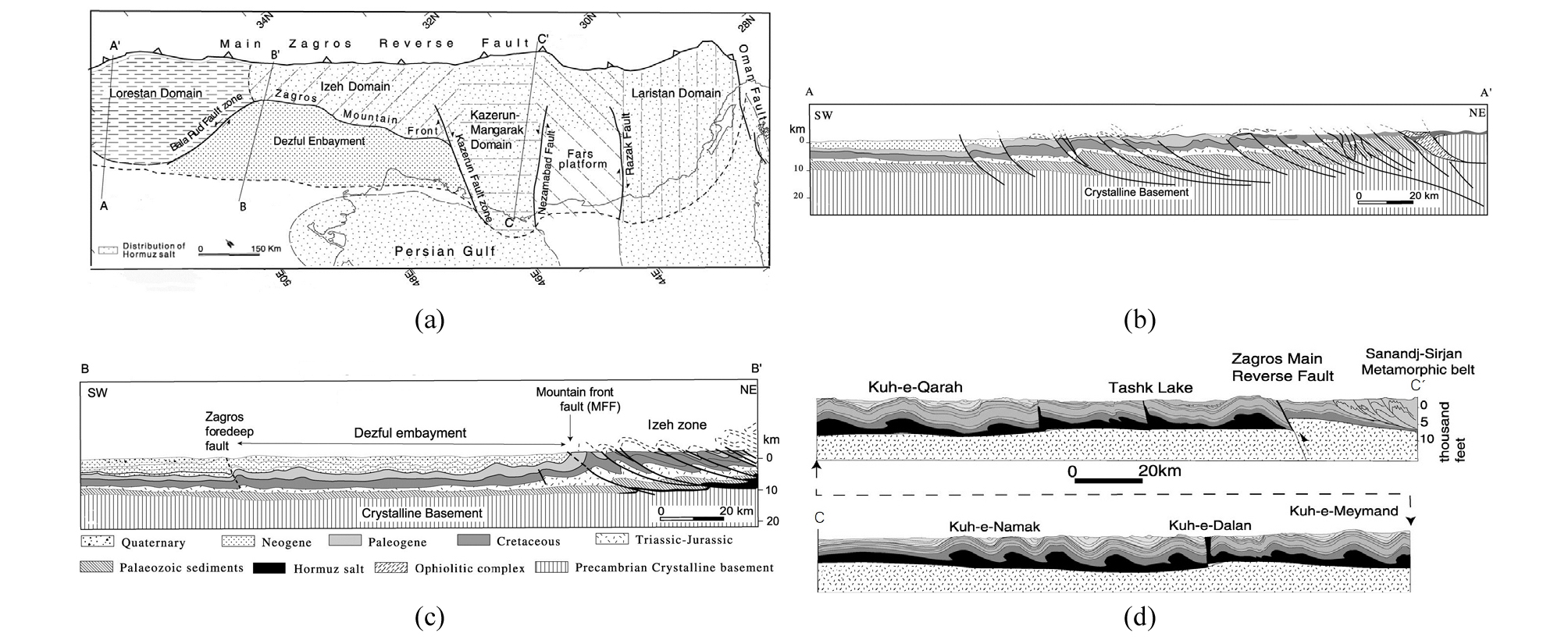
Fig. 23.
Cross-sections illustrating difference in deformation styles of Lurestan, Dezful. and Fars domains (Bahroudi and Koyi, 2003). (a) Map showing the main structural domains of the Zagros thrust-fold belt and location of cross-sections, Note distribution of the Hormuz salt, (b) Cross-section of the Lurestan domain. Note an imbricate stack of thrusted blocks, (c) Cross-section of the Dezful domain. Note that the Mountain Front Fault separates the Dezful Embayment with low deformation from the narrow highly deformed thrust-folded zone. (d) Cross-section of the Fars domain. Note the wide folded zone consisting of salt-cored anticlines.
데즈풀의 SFB (또는 Izeh zone)는 스러스트 단층과 연계된 남서쪽으로 향하는 비대칭형의 강제 습곡들로 구성되는데, 가장 경사가 급한 바흐티아리(Bakhtiari)는 폭이 50 km 내외이고, 긴밀하고 짧은 파장의 습곡들이 운집해 있으며, 남서쪽으로 변형 강도가 감소하고 긴 파장으로 변하여 느슨해진다. 이제(Izeh) 지역의 습곡 길이는 평균 87 km, 일부는 200~310 km에 달하며, 노출된 배사들은 폭이 7.3 km이고, 주변보다 2~3 km 높다(Bahroudi and Koyi, 2003). 데즈풀은 지표 경사 2°, 하부 분리면 경사 2°, 합계 경사 각도(taper angle) 4°이며(McQuarrie, 2004; Sherkati and Leto-uzey, 2004), 단축도 20%로 루레스탄이나 파르스에 비해 큰 값을 보이는데, 아라비아 육괴의 열개 당시로부터 유래된 기반암의 지형, 요철-요각(salient-embayment 또는 pro-montory-reentrant) 구조, 또는 하부 분리대를 구성하는 층의 윤활 효율성 차이 등으로부터 야기된 것으로 해석된다(Talbot and Alavi, 1996; Bahroudi and Koyi, 2003; McQuarrie, 2004; Sepehr and Cosgrove, 2004; Sherkati et al., 2006; Allen and Talebian, 2011).
파르스는 하부에 분포하는 두께 1~2 km의 호르무즈 암염 충이 습곡 형성 과정에서 중요한 역할을 한다. 파르스의 SFB는 파장(평균 길이 15.8±5.3 km)과 진폭(500-1,000 m)이 일정한 대칭형의 길이가 비교적 짧은(<50 km) 습곡들이 균일하게 분포하여 완만한 지표 경사(<1°)를 형성한다(Sattarzadeh et al., 2002; Mouthereau et al., 2006, 2007a). 파르스의 습곡은 반 파장:축 길이 비(half wavelength/hinge length ratio)가 1:10 미만의 전형적인 좌굴 습곡이며, 다른 지역과 달리 단층에 연계된 강제 습곡이 드물고, 단축도는 6~9%로 작다(Fig. 49 참조)(Jahani et al., 2009). 기반암이 수반된(thick-skinned) 변형은 MFF와 파르스 중부에 있는 수르메(Surmeh) 단층과 연계된 고도차 500~700 m의 단애와 심부 지진 등에 의해 추정되고, 긴 파장(40~100 km)의 지형적 기복(undulation)으로 나타나며, 전체 단축(65~78 km; 단축도 16~19%)의 3/4 가량을 분담한다(Mouthereau et al., 2007a, b, 2012; Molinaro et al., 2005; Sherkati et al., 2006; Leturmy et al., 2010).
High Zagros는 Bangestan 층군을 비롯한 쥐라기~백악기 탄산염암 층의 배사들이 지표 지질을 구성하는 폭 40~80 km의 충상 단층대(overthrust belt)로, 주로 신생대 Asmari 층의 배사들로 이루어진 SFB와 구분된다(Berberian, 1995). HZ는 충돌 초기(백악기 후기)에 압등한 이지성(allochthonous)의 오피올라이트와/또는 방산충 층, 해산형(seamount) 탄산염암 층(Bisotun limestone), 심해저에서 퇴적된 탄산염암 층(Pichakun series) 등으로 이루어진 나페(nappe)들을 포함하며(Fig. 24)(Haynes and McQuillan, 1974; Navabpour et al., 2010, 2011; Agard et al., 2011; Mohajjel and Fergusson, 2014). 이들로부터 유입된 퇴적물로 조성된 백악기 후기~신생대 고기 플리시(Amiran 층)와 몰라세(Kashkan 층)가 북동으로부터 남서 방향으로 얇아지는 쐐기형 암체로 자그로스 최초의 전면 분지(proto-Zagros foreland basin)를 형성한다(Homke et al., 2009; Casciello et al., 2009). 오피올라이트는 루레스탄의 케르만샤와 파르스의 네이리즈 지역에 분포하고, 연대는 백악기 후기로 알려져 있다(Delaloye and Desmons, 1980; Moghadam and Stern, 2011, 2015). 방산충 층은 두께가 500 m이고, 심하게 습곡되어 있으며, 트라이아스기~백악기 방산충이 군집된 규질암과 셰일 또는 이회암이 교호하여 구성한다(Agard et al., 2005). Bisotun 층은 트라이아스기 후기~백악기 후기 비교적 얕은 수심에서 퇴적된 두께 3,000 m의 석회암으로, 구조적으로 오피올라이트의 하부에 위치한다. Pichakun 층은 트라이아스기~백악기 동안의 수동형 아라비아 대륙 주변부 사면 및 대륙대에서 중력류에 의해 퇴적된 다양한 암상의 탄산염암과 표영 생물과 부유물이 침강하여 퇴적된 방산충 규암과 연니층 등을 포함하며, 두께는 400~700 m이고, 이들이 스러스트에 의해 반복되는 나페의 총두께는 2,000 m에 달한다(Ricou, 1970; Robin et al., 2010).
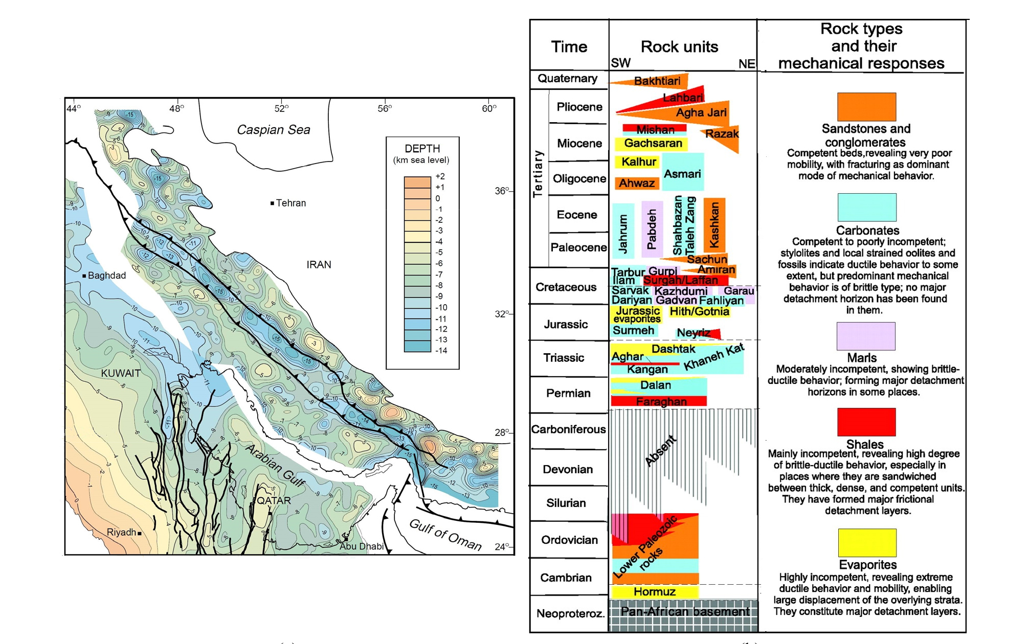
층서
자그로스는 중‧고생대 동안 아라비아 순상지로부터 완만하게 경사하는 대지의 연해 환경에 위치하여 층서와 퇴적상도 그 연장선에서 해석되며(Murris, 1980; Konert et al., 2001; Ziegler, 2001; Ko, 2015), 유라시아 판과의 충돌이 시작되는 백악기 후기 이후에는 분지의 설정이 전면 분지로 바뀌면서 조산 동시성 퇴적물과 증발암 위주로 층서를 구성한다. 자그로스의 기반암은 과거 섭입부로 판 경계를 형성하는 MZF와 HZF 사이의 HZ에서 가장 깊고, SFB에서는 기반암을 동반하는 스러스트(MFF, ZDF 등)에 의해 융기해 있으며, 전면 분지에서는 조산대와 퇴적층의 하중으로 침강하여 깊이가 9 km 이상이다(Konert et al., 2001)(Fig. 19). 기반암의 지형과 구조는 원생대 곤드와나 초대륙이 형성되는 과정(Pan-African Orogeny)에서 발달된 아라비아 대지의 구조 성분인 N-S 방향(Arabian Trend)과 NW-SE 방향(Najd Trend)의 영향을 지속적으로 받고 있으며, 자그로스의 구조 단위를 구분하는 단층(MZF, HZF, MFF, ZDF, Kazerun 단층 등)들도 이들과 밀접하게 결부되어 있다(Bahroudi and Talbot, 2003; Alabi, 2007). 카제룬 단층을 경계로 기반암 등심선이 분리되어 파르스와 데즈풀 지역을 가르며, 데즈풀과 루레스탄 사이에는 발라루드 단층과 평행하게 얕은 기반암 벨트가 발달한다.
자그로스의 퇴적은 곤드와나 초대륙을 형성한 조산 운동에 뒤따르는 신장 작용(post-orogenic extension)으로 신원생대 후기 아라비아를 비롯하여 이란, 파키스탄 지역 등에 열개 분지가 발달하면서 시작되었다(Husseini, 1988; Husseini and Husseini, 1990; Stern and Johnson, 2010). 자그로스에 발달한 열개 분지의 범위는 호르무즈 암염에 의해 형성된 돔들이 분포하는 파르스 지역과 HZ에 한정되며, 카제룬 단층 너머 데즈풀과 루레스탄 지역은 암염층의 존재가 8~12 km 두께의 상부 퇴적층에 의해 가려져 불확실하다(Kent, 1979; Talbot and Alavi, 1996; Jahani et al., 2007; Callot et al., 2007, 2012)(Figs. 11a, 23a). 호르무즈 암염층의 퇴적 시기는 선캄브리아기 말~고생대 초(Infra- 또는 Eo-Cambrian)이며, 초기 두께는 1~2 km로 알려져 있다. 호르무즈 암염층의 유동은 페름기까지 거슬러 올라가며, 신생대 신기 자그로스 조산 운동과 더불어 본격화되었다. 호르무즈 암염 돔은 스러스트 또는 주향이동 단층들과 연접하거나 배사들의 핵을 형성하며 ~160개가 분산 분포하고, 암염 침(pillow)은 성장하면서 상부 특히 중생대 층의 등후(isopach) 패턴에 영향을 주고 있다(Ala, 1974; Bahroudi and Talbot, 2003). 암염층은 매우 연약하여 작은 응력에도 전단되어 층면에 평행하게 분리되고, 연성 및 점성적 특성은 견고한(competent) 상부층의 변형과 전진을 용이하게 하며, 스러스트-습곡대의 경사(taper)를 완만하게 하는 등 조산 과정에서 중요한 역할을 한다(Davis and Engelder, 1985; Cotton and Koyi, 2000; Bahroudi and Koyi, 2003).
자그로스의 고생대는 아라비아로부터 이란 본토에 이르는 광대한 대지의 일부를 구성하며 얕은 연해 환경에서 사암, 이암 및 탄산염암이 퇴적되고, 데본기~석탄기 동안 곤드와나와 로러시아(Laurussia) 초대륙이 충돌하는 헤르시니아 조산운동의 원격 영향에 따른 융기와 삭박으로 결층된 후, 페름기 곤드와나로부터 이란이 분리되고 MZF에 수동형 대륙주변부가 형성되면서 탄산염암의 퇴적이 본격적으로 시작했던 시기이다(Fig. 25). 자그로스의 고생대 하부는 이란 본토와 동일하게 천해 환경에서 퇴적된 캄브리아기 Lalun 적색 사암, Mila 탄산염암, 오르도비스기 Zard Kuh 이암 등으로 구성되고, 각각의 두께는 1,500 m, 420 m, 325 m이다(Berberian and King, 1981; Alsharhan and Nairn, 2003; Bordenave, 2008). 실루리아기는 간빙기로 해수면이 최대 상승하여 중동 지역의 주요 근원암인 Qusaiba 셰일이 퇴적되던 시기였으나 삭박으로 파르스와 루레스탄 일부를 제외한 지역에는 분포하지 않으며, 데본기 이후 석탄기까지의 지층은 거의 확인되지 않는다(Fig. 26)(Konert et al., 2001).
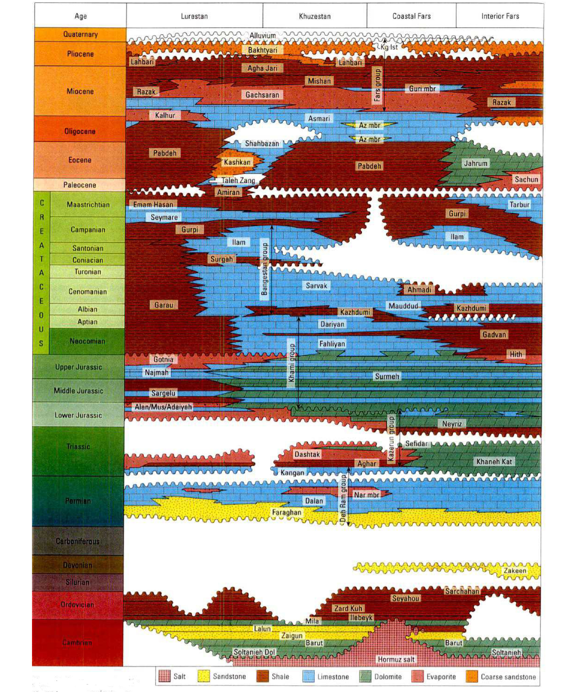
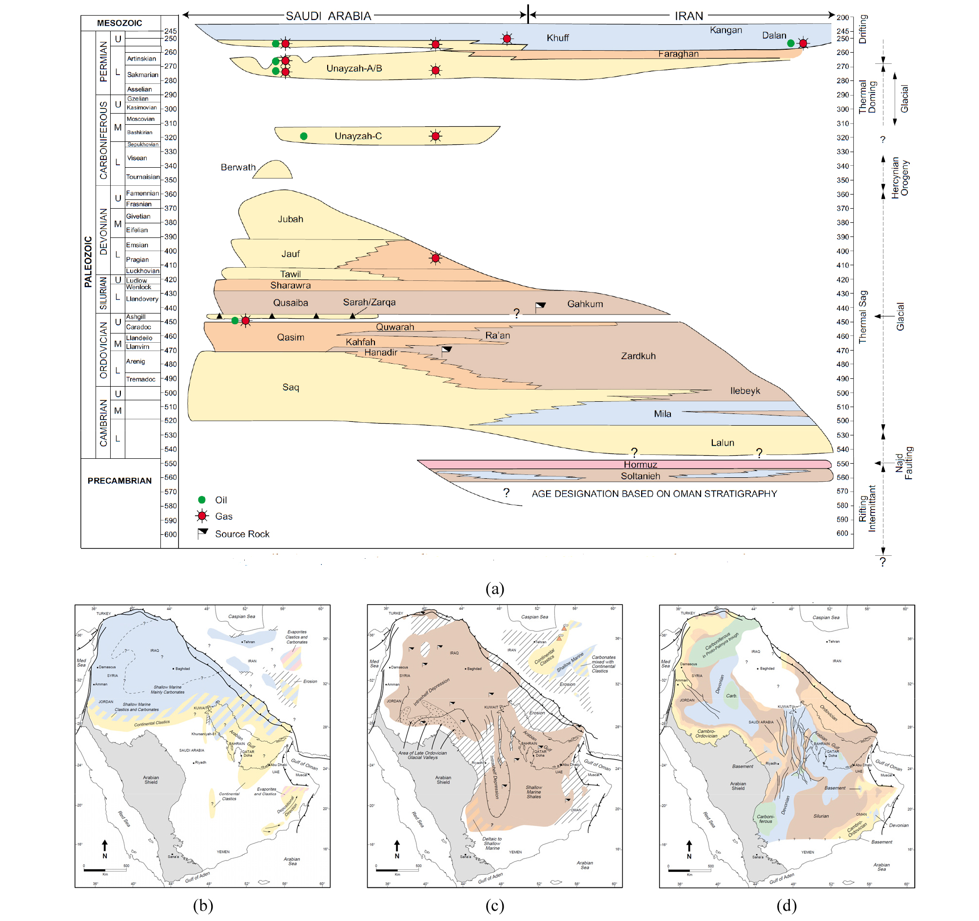
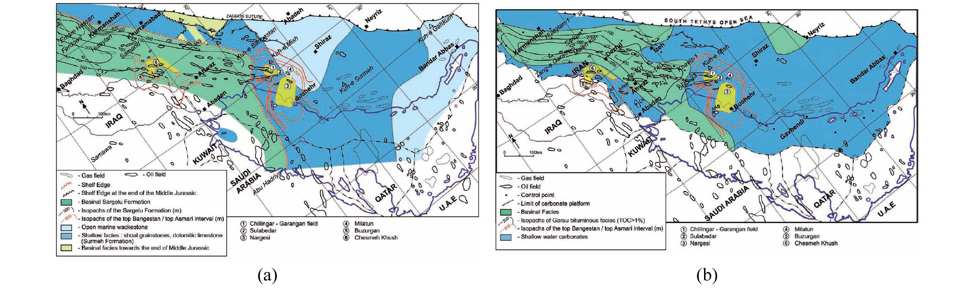
고생대 말 페름기는 판게아 해체의 전조로 곤드와나 주변에서 이란이 분리되고 새로운 테티스 해(Neo-Tethys)가 생성되는 지체 구조의 대변혁이 일어났던 시기로, 자그로스는 열적 침강으로 침수되고 퇴적이 재개되었다. 헤르시니아 부정합면 위로 해침성 기저 사암인 연안 퇴적상의 Faraghan 층이 쌓이고, 탄산염암과 증발암의 조합으로 이루어진 Dalan 층이 쌓이는데, 각각 아라비아 대지의 Unayzah 층과 Khuff 층에 대비되며, 모식지(type locality)에서 알려진 두께는 200~420 m와 640 m이다(Kashfi, 1992, 2000). Khuff 층은 회수가능 매장량이 2,680 Tcf에 달하는 세계 최대의 가스 저류층이며(Pollastro, 2003; Pöppelreiter, 2014), 이란 파르스 지역의 Dalan 층은 상부 트라이아스기의 Kangan 층과 더불어 ~200 Tcf를 부존한다(Bordenave, 2008). Dalan 층은 증발암(Nar 층원; 두께 ~300 m)을 사이에 두고 상‧하부 탄산염암으로 구성되는데, HZ에 암초대(reef belt)와 전초 사면(fore reef slope) 퇴적상이 발달하고, SFB와 전면 분지는 해수면 변동에 따라 탄산염암과 증발암의 영역이 확장 또는 축소하며 순차 퇴적하는 민감한 대륙붕 해역에 위치하였다(Szabo and Kheradpir, 1978; Konert et al., 2001; Alsharhan, 2006; Insalaco et al., 2006; Ehrenberg et al., 2007; Esrafili-Dizaji and Rahimpour-Bonab, 2013)(Fig. 27).
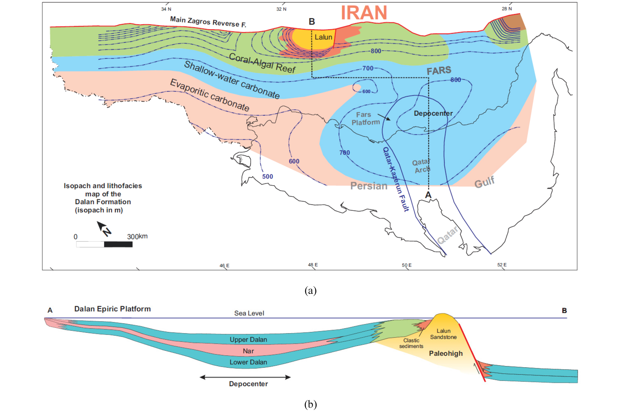
트라이아스기 Kangan 층은 Faraghan, Dalan 층과 더불어 Dehram 층군에 속하는데, Khuff 층의 상부 층원에 대비되고. Dalan 층과 비슷한 암상과 물성으로 저류 측면에서 연속체를 형성한다(Fig. 46 참조)(Insalaco et al., 2006). Kangan 층은 어란석, thrombolite, 석호에서 퇴적된 석회질 점토, 증발암 등으로 구성되며, 총 두께는 ~160 m이다. 어란석은 조하대의 모래톱(shoal)에서 형성되는데, 낮은 경사의 대지와 그 연장선 상의 대륙붕이 해침으로 해파와 조수의 작용이 활발한 외해(open ocean)가 되면서 광대한 영역에 발달하여 탁월한 저류성을 갖는 입자암(grainstone)이 된다. 광대한 대지와 대륙붕은 작은 해수면 하강에도 모래톱 등이 외해와 격리하는 지형적 요소로 작용하여 증발암과 석회질 점토가 축적되는 환경으로 쉽게 변화한다.
트라이아스기 후기는 증발암(Dashtak 층)이 광범위하게 퇴적된다. 동시기 탄산염암은 HZ와 파르스의 남동 모퉁이에 분포하고 Khaneh Kat 층으로 불리는데, 백운석화 되었으며 상당 기간 지상 노출에 따른 용식으로 상부에 카르스트가 발달한다. Dashtak 층은 기저에 두께 10~40 m의 셰일(Aghar 셰일 층원)을 포함하는데(Szabo and Kheradpir, 1978), Khuff 이후 해수면이 하강하여 쇄설 환경이 전진하면서 퇴적된 대지 상의 Sudair 층에 대비된다(Ziegler, 2001). 트라이아스기 후기 층의 두께는 대략 500~1,000 m이고(Koop and Stonley, 1982; Alavi, 2007), 데즈풀과 루레스탄 지역의 북부에서는 쥐라기 이전의 삭박으로 250 m 정도만 남거나(Alavi, 2004). SFB에서는 스러스트와 습곡에 따른 유동으로 1,400~1,900 m로 두껍기도 하며(Najafi et al, 2014), 모식지에서는 Dashtak 층 814 m, Khanet Kat 층 360 m로 기재된다(Szabo and Kheradpir, 1978; James and Wynd, 1965)(Fig. 28).
쥐라기는 해침성 쇄설암을 기저에 포함하는 Neyriz 층으로 시작하여, Surmeh 층으로 이어지면서 탄산염암이 본격적으로 퇴적된다(James and Wynd, 1965; Szabo and Khera-dpir, 1978). 같은 시기 루레스탄 지역에는 상대적으로 깊고 고립된 분지(intrashelf basin)가 발달하여 셰일 또는 점토질 석회암(Mus, Sargelu)과 증발암(Adaiyah, Alan)이 번갈아 퇴적된다. 쥐라기 말 루레스탄 지역은 분지형 증발암(Gotnia)에 의해 마무리되고, 그 외 지역에서는 사브카형 증발암(Hith) 영역이 확장되면서 탄산염암 영역이 줄어든다(Setudehnia, 1978)(Fig. 29). 쥐라기 층의 총 두께는 대략 500~1,000 m이고, 각각의 모식지에서 Neyriz 350 m, Surmeh 689 m, Adalyah 63 m, Mus 56 m, Alan 90 m, Sargelu 160~220 m, Najmah 19 m, Gotnia 141 m, Hith 75~94 m로 알려졌다(Alsharhan and Nairn, 2003).
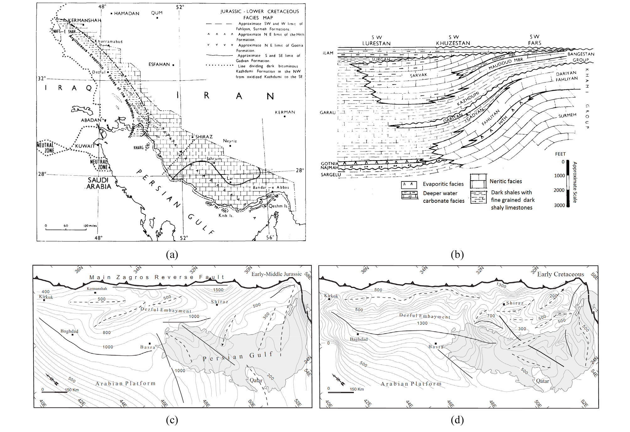
Fig. 29.
Jurassic to Early Cretaceous paleogeography of the Zagros. (a) Lithofacies distribution, (b) Composite stratigraphic section illustrating the along-strike facies changes from Fars to Lurestan (James and Wynd, 1968), (c) Isopach map for the Early-Middle Jurassic, (d) Isopach map for the Early Cretaceous (Koop and Stoneley, 1982; Modified by Bahroudi and Talbot, 2003)
백악기는 쥐라기와 비슷한 퇴적 환경에서 소구상 및 어란상 석회암(Fahliyan 층: Neocomian, 두께 300~400 m)으로 시작하여 주요 저류암을 구성하는 Sarvak (Cenomanian, 800~900 m) 및 Ilam (Santonian-Campanian, 200 m) 층을 포함하는 Bangestan 층군 등 천해역 탄산염암 퇴적이 지속된다(James and Wynd, 1965; Setudehnia, 1978; Alsharhan and Nairn, 2003). 쇄설 영역이 확장하던 해퇴 시기에 Zubair (Hauterivian-Barremian), Burgan (Albian) 사암 등과 더불어 퇴적되었던 Gadvan (두께 150 m), Kazhdumi (두께 250 m) 층 등은 유기물이 풍부한 셰일 또는 이회암을 포함한다(Fig. 30). 루레스탄 지역은 여전히 깊은 수심의 대륙붕내 분지로 흑색 셰일과 점토질 석회암으로 이루어진 Garau 층(Neocomian-Coniacian, 700 m)이 퇴적된다. 백악기 후기 오피올라이트의 압등과 연계된 융기와 삭박으로 아라비아 판 전역에서 인지되는 광역 부정합(Mid-Turonian unconformity)이 형성된 후, 대륙붕 지역은 침강으로 비교적 깊은 수심에서 주로 이회암으로 이루어진 Gurpi 층(Santonian-Maastrichtian, 100~300 m)이 퇴적되고, HZ에 위치한 전면 곡분에는 플리시로 이루어진 Amiran 층(900 m)이 퇴적되며(Saura et al., 2011, 2015; Homke et al., 2009), 파르스 지역 북부에서는 천해역 탄산염암(Tarbur 층, 500 m)의 퇴적이 지속된다(James and Wynd, 1965; Koop and Stoneley, 1982).
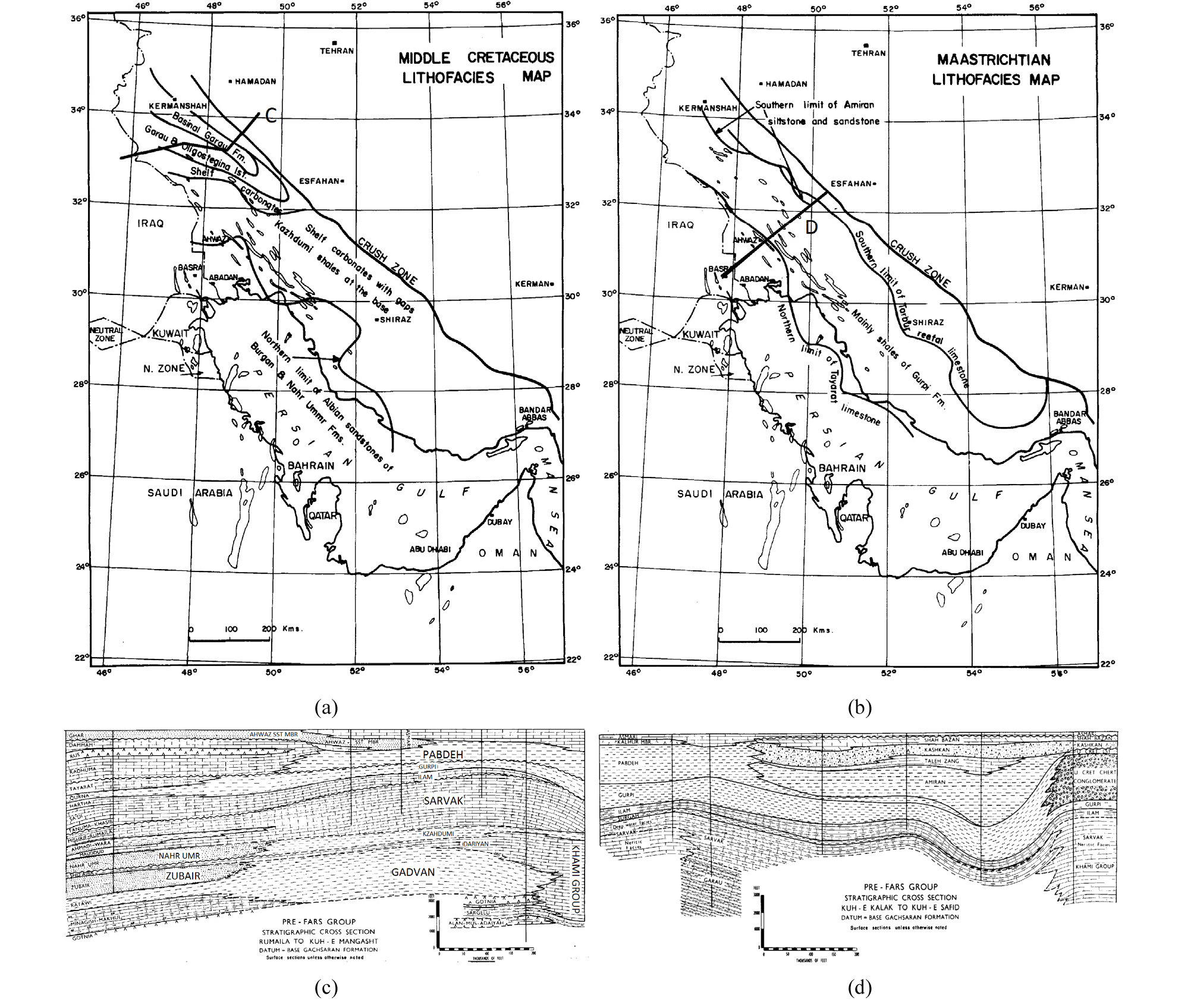
Fig. 30.
Late Cretaceous paleogeography of the Zagros. (a) Facies distribution for the Albian-Turonian, (b) Facies distribution for Maastrichtian (Setudehnia, 1978), (c) Stratigraphic cross-section of Lurestan, (d) Stratigraphic cross-section of Dezful with datum at the base of the Gachsaran Formation (James and Wynd, 1968).
신생대는 자그로스의 구조 설정이 테티스 해의 소멸로 대륙 주변부 지체로부터 조산대의 전면 분지로 전이하고, 홍해 및 아덴만 생성으로 아라비아 판이 아프리카 판으로부터 분리되는 등 대규모 지체 구조 변동의 시기로, 지사가 복잡 다단하며, 퇴적 환경 및 층서도 따라서 다양해진다. 신생대 고기 백악기 말 심해를 형성했던 전면 곡분이 지속된 압축으로 융기하고 퇴적 중심이 남서 방향으로 이동하면서, Amiran 플리시는 Kashkan 몰라세(두께 300~400 m)로 대체되고, Gurpi 층은 쇄설층의 비율이 증가된 Pabdeh 층(200~600 m)으로 이어지며, 파르스 지역에서는 석호상 또는 암초상 탄산염암으로 이루어진 Jahrum 층(200~700 m)이 퇴적된다(Fig. 31). 올리고세 오피올라이트 압등에 따른 구조적 재조정이 마무리되고 소강 상태에 접어들어 비교적 안정된 환경이 되면서 천해역 탄산염암으로 구성된 Asmari 층이 Paddeh 층 상부로 전진 구축하면서 쌓인다(James and Wynd, 1965; Ehrenberg et al., 2007). Asmari 층은 분지 전면 완사면의 간석지로부터 외부 깊은 조하대에서 퇴적된 ~400 m 두께의 치밀하고 단단한 괴상 석회암으로, 습곡 및 스러스트 형성 과정에서 발달한 단열에 의한 공극이 자그로스에서 산출되는 석유의 90% 이상을 부존하여, 가장 중요한 저류층을 구성한다(Beydoun et al., 1992; Al-Aasm et al., 2009).
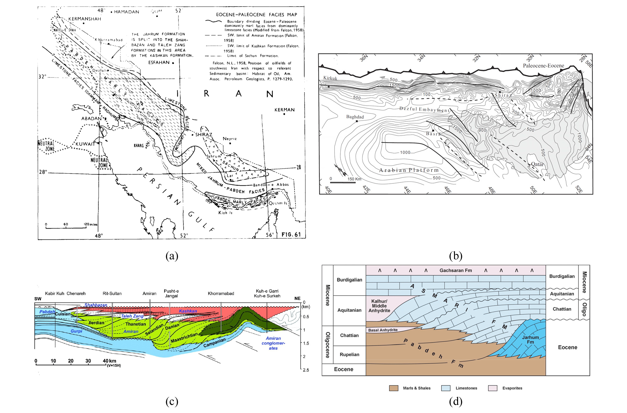
Fig. 31.
Paleogene paleogeography of the Zagros. (a) Facies distribution for the Paleocene-Eocene (James and Wynd, 1968), (b) Isopach map for the Paleocene-Eocene (Koop and Stoneley, 1982; Modified by Bahroudi and Talbot, 2003), (c) Schematic stratigraphy of the Amiran Foreland basin in Lurestan (Saura et al., 2011), (d) Schematic stratigraphy of the Asmari Formation and laterally equivalent formations (Ehrenberg et al., 2007).
신생대 신기 대륙간 충돌이 본격화되고 자그로스의 조산 운동이 가속화되면서, 동시적으로 전면 분지를 Fars 층군이 채워 가는데, Gachsaran, Mishan, Agha Jari 층 등으로 합친 두께가 기반암 상부 전체 퇴적층의 1/3 이상을 차지한다. 마이오세 전기 아라비아 판과 이란 판이 합체되고 자그로스가 융기하면서, 전면 분지와 대양과의 연결이 제한된 환경에서 증발암 위주의 Gachsaran 층이 1,000-1,500 m 두께로 퇴적된다(Fig. 32). 마이오세 중기 조산대의 하중에 의한 침강과/또는 해수면 상승에 따른 해침으로 석회암초(Guri 층원)와 이회암으로 이루어진 Mishan 층이 ~800 m 두께로 퇴적되고, 마이오세 후기 자그로스 대부분이 스러스트-습곡 작용으로 융기되고 육화되면서 스러스트 사이(piggyback or wedge-top) 또는 전면(foredeep)의 선상지 및 망상‧사행 하천에서 퇴적한 쇄설암으로 이루어진 Agha Jari 층(마이오세 중기~플라이오세, 650-3,250 m)과 Bakhtyari (플라이오세 말~플라이스토세, 600 m)이 쌓이고, 현재는 퇴적 중심이 MFF 전면의 메소포타미아 평원과 페르시아 만으로 이동해 있다(Pirouz et al., 2011, 2015).
석유지질
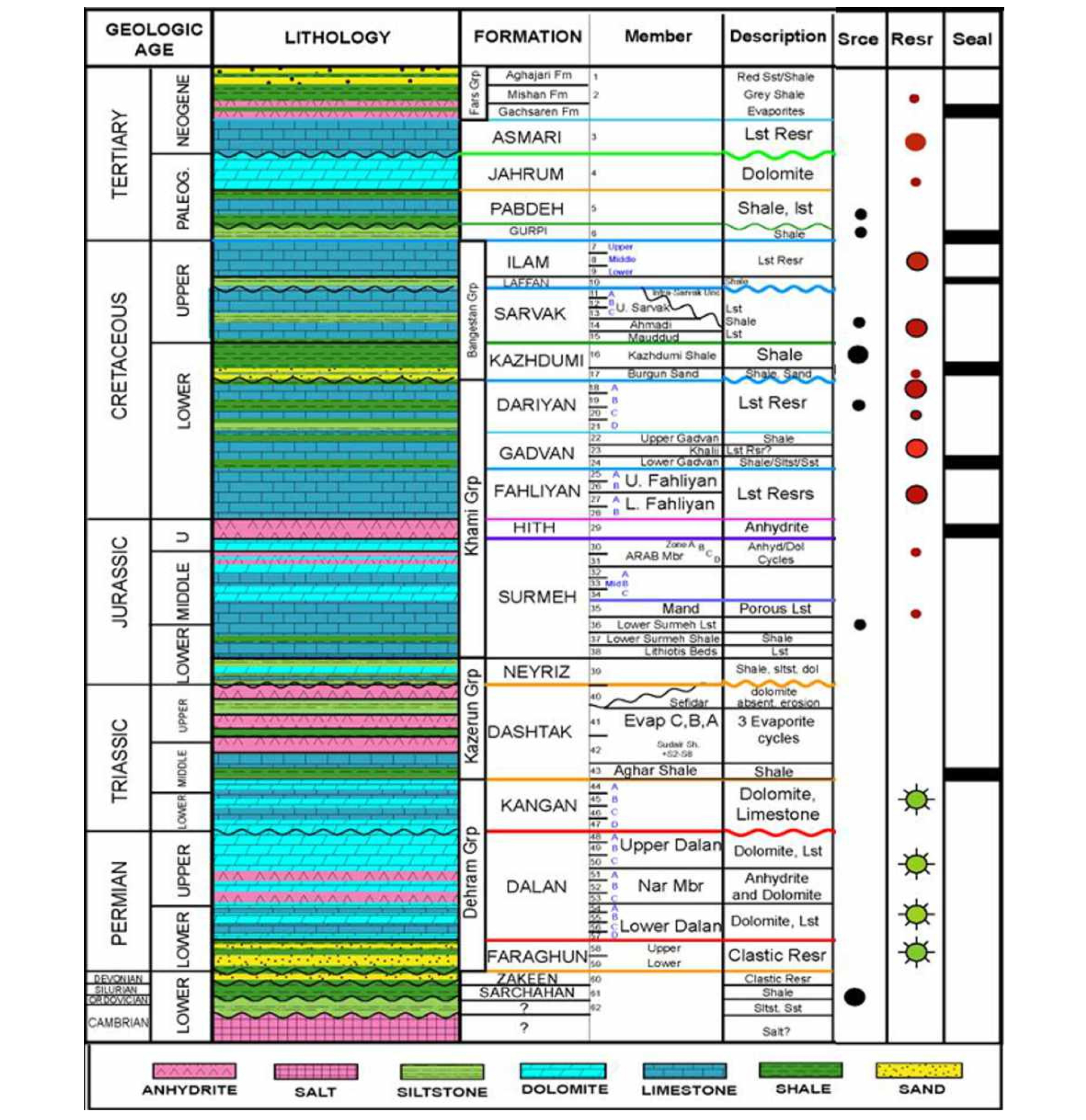
이란은 1979년 이슬람 혁명 이후 석유 탐사에 있어서 필수적인 지식과 기술의 진보로부터 단절되어, 석유지질 정보가 구시대적이고, 단편적인 면이 있다. 지난 40년 동안 판구조론, 분지 해석, 퇴적상, 순차 층서, 석유 시스템, 자료 처리 분야 등은 눈부시게 발전했으며, 석유 분야에서 이들 지식들이 광범위하게 융합‧적용되고 있다. 이란의 석유와 가스는 데즈풀과 파르스 지역의 습곡 구조에 집중 분포하고, 각각에 대해 올리고세 Asmari 층과 페름기~트라이아스기 Dalan 및 Kangan 층이 저류층을, 백악기 Kazhdumi 층과 실루리아기 Sarchahan 층 등이 근원암을, 마이오세 Gachsaran 층과 Dashtak 층이 덮개암을 형성하는데(Fig. 33), 서방의 새로운 개념과 신기술이 활용되어 이란의 석유지질에 대한 이해가 제고되면, 신규 석유 체계(play) 및 유전 발견의 가능성과 기회가 한층 높아질 것으로 보인다.
근원암
이란은 여러 지질 시대에 걸쳐 양질의 근원암이 분포하는 아라비아 대륙의 일원으로 생산성 높은 석유 시스템을 보유하고 있다(Fig. 34). 실루리아기 Sarchahan 층은 세계 최대의 가스전인 South Pars/Qatar North를 비롯하여 중동 지역에서 산출되는 가스의 주요 근원암으로 알려진 Qusaiba 셰일과 대비된다. Qusaiba 층은 실루리아 전기 곤드와나를 광범히 덮고 있던 빙하가 녹고 해수면이 높이 상승했던 간빙기에 퇴적된 흑색 셰일로 기저에 9~31 m 두께의 유기물 함량이 평균 3~5%, 최대 20%에 달하는 우수한 근원암을 포함한다(Mahmoud et al., 1992; Cole et al., 1994; Jones and Stump, 1999; Bordenave, 2008; Ko, 2015). 이란의 Sarchahan 층은 헤르시니아 구조운동에 따른 삭박으로 파르스 지역 동부에 제한적으로 분포하는데(Konert et al., 2001), 자그로스 조산운동으로 융기하기 이전 매몰 깊이가 6,000 m 이상에 도달해 과성숙(Tmax≃460°C) 상태이다(Bordenave, 2008, 2014; Bordenave and Hegre, 2010)(Fig. 35). Sarchahan 층은 매몰 깊이 2,900~3,000 m에서 석유 생성, 3,100~3.200 m에서 석유 방출, 5,600 m에서 가스 생성 단계에 도달했을 것으로 추정되는데(Bordenave, 2008), Qatar-Gavbendi 융기대는 매몰 심도가 얕아 South Pars 및 파르스 연안 등에서 산출되는 막대한 양의 가스는 다른 깊은 근원지에서 생성되어 이동해왔을 가능성이 높다(Aali et al., 2006; Bordenave and Hegre, 2010). Sarchahan 층의 유기물은 II형이며, 수소지수는 40~110 gHC/kg, δ13C은 –30.8‰이고(Bordenave, 2008). 이로부터 기원된 가스는 δ13C이 ~40‰로 열적 분해로 생성되었음을 지시한다(Aali et al., 2006; Saberi and Rabbani, 2015). 가스 성분은 탄화수소가 89.6~97%이고 구성은 메탄 74.3~88.7%, 에탄 1.7~7.25%, 프로판 0.4~3.9%이며, 부탄 등은 2.5% 미만이고, 기타 질소 0.9~9%, 이산화탄소 0.9~7%, 황화수소 <0.2% 등을 포함한다(Saberi and Rabbani, 2015).
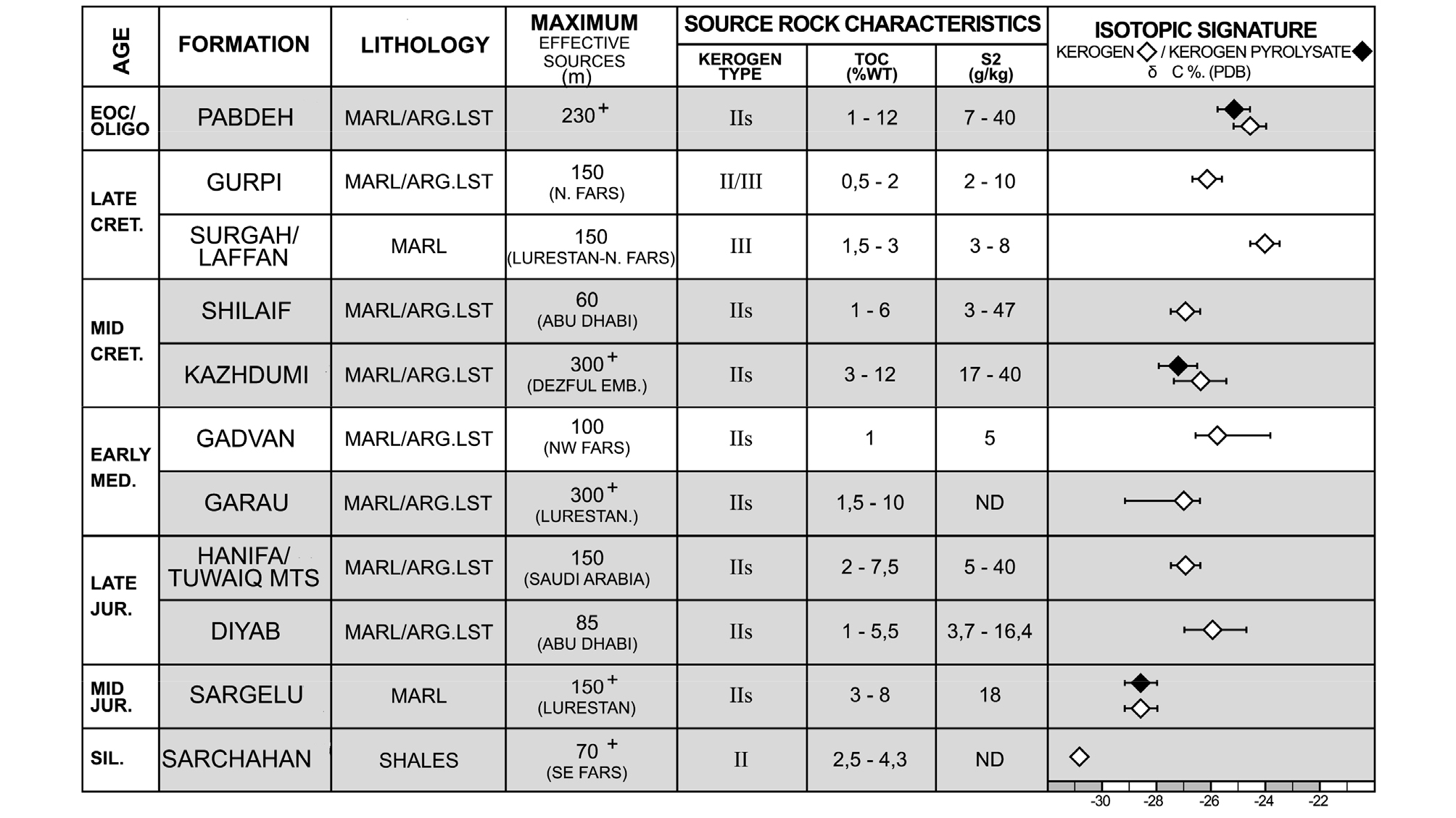
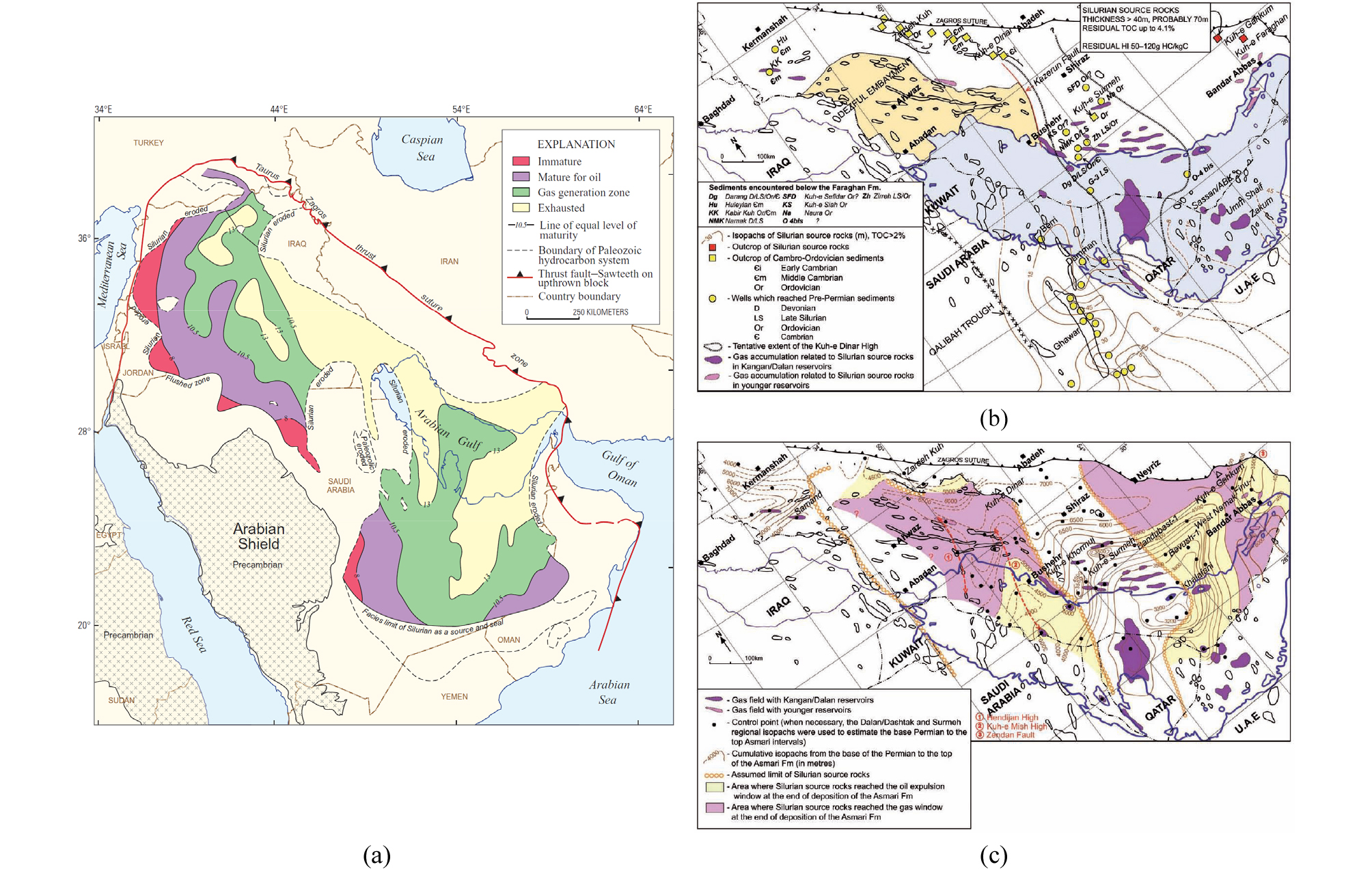
Fig. 35.
Source rock; Sarchahan Formation. (a) Map showing distribution and present-day thermal maturity of the Lower Silurian source rock in Arabia and Zagros (Bishop, 1995; Modified by Fox and Ahlbrandt, 2002). (b) Distribution and thickness of the Lower Silurian source rock in the Zagros and Persian Gulf, (c) Cumulative isopach map of overburden for the Lower Silurian source rock from the base Permian to the top of the Early Miocene Asmari Formation (Bordenave, 2014).
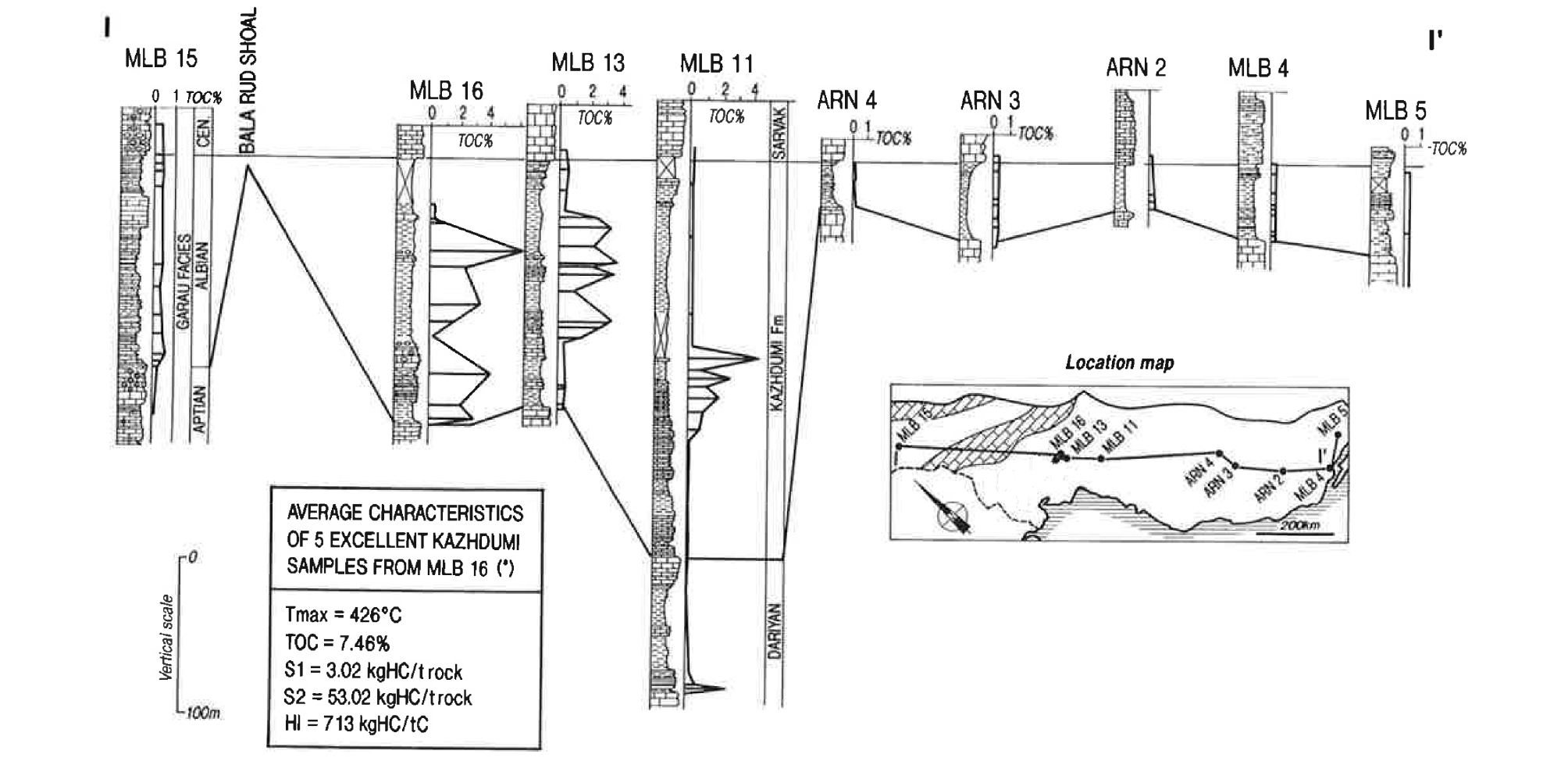
데즈풀 지역에 집중적으로 분포하는 유전들에서 산출되는 석유는 비중 24~32°API, 포화 탄화수소 ~68%, 왁스분 4~5%, 아스팔트분 0.4~7.4%, 황분 1.5~3.2%이며, 탄소 및 황 동위원소 값이 각각 –26.3~27.5‰ PDB와 –7.3~7.3‰ CDT로, 백악기 Kazhdumi 층의 유기 추출물과 유사한 값을 보인다(Ala et al., 1980; Bordenave and Burwood, 1990, 1995; Bordenave and Huc., 1995; Alizadeh et al., 2007; Bordenave and Hegre, 2010; Bordenave. 2014; Mehmandosti et al., 2015)(Fig. 36). Kazhdumi 층은 쇄설 영역이 크게 확장되었던 알비세(Albian) 대륙붕내 분지에 발달한 무산소 환경에서 퇴적된 역청질 셰일 또는 이회암으로, 데즈풀에 퇴적 중심을 형성하며 유기물 함량 1% 이상인 층들의 누적 두께가 최대 450 m에 달한다(Fig. 37). Kazhdumi 층은 연안 및 삼각주 환경에서 퇴적된 Burgan 사암 및 Nahr Umr 쇄설암과 대비되는 전위 삼각주 셰일로, 유기물은 함량 3.1~12.0 wt.%, 유형 type II, 열분해 S2 17~40 mgHC/g dry rock, 수소지수 200~450 mgHC/gTOC이며, 황분이 4.95~5.55%이고, 탄소 및 황 동위원소 값이 각각 –26.7±0.2‰ PDB와 0.2±0.05‰ CDT이다(Fig. 38). Kazhdumi 유기물은 비트리나이트 반사도 0.45~1.0 %Ro의 범위이며, 전면 분지의 퇴적 중심에서 0.80 %Ro 이상의 높은 성숙도를 보이는데, 10 Ma경 ~5,500 m 매몰 깊이에서 석유 생성 단계(Ro=0.60%)에 도달했었을 것으로 추정된다(Bordenave and Burwood, 1990, 1995; Bordenave and Huc., 1995; Sfidari et al., 2016)(Fig. 39).
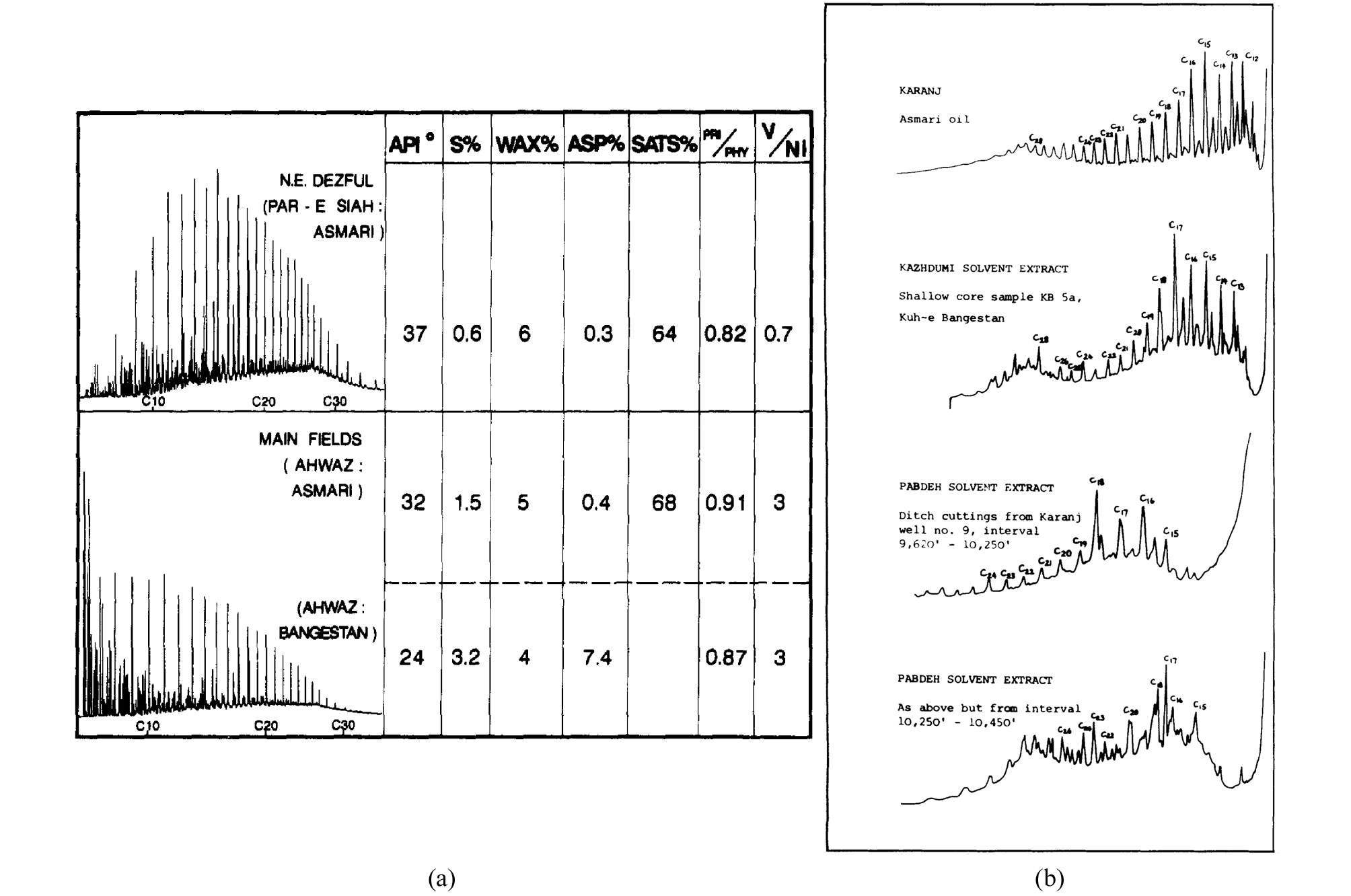
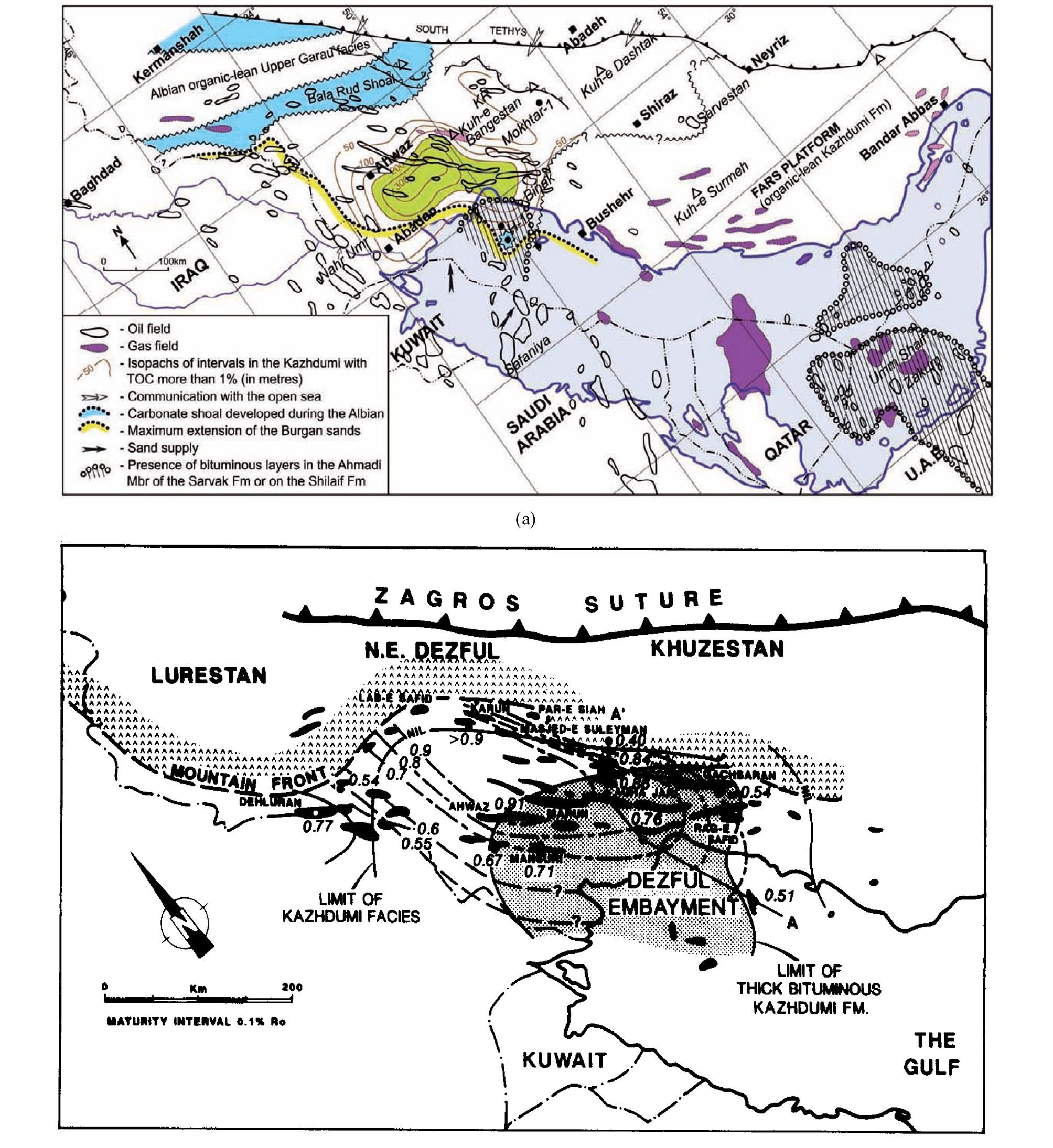
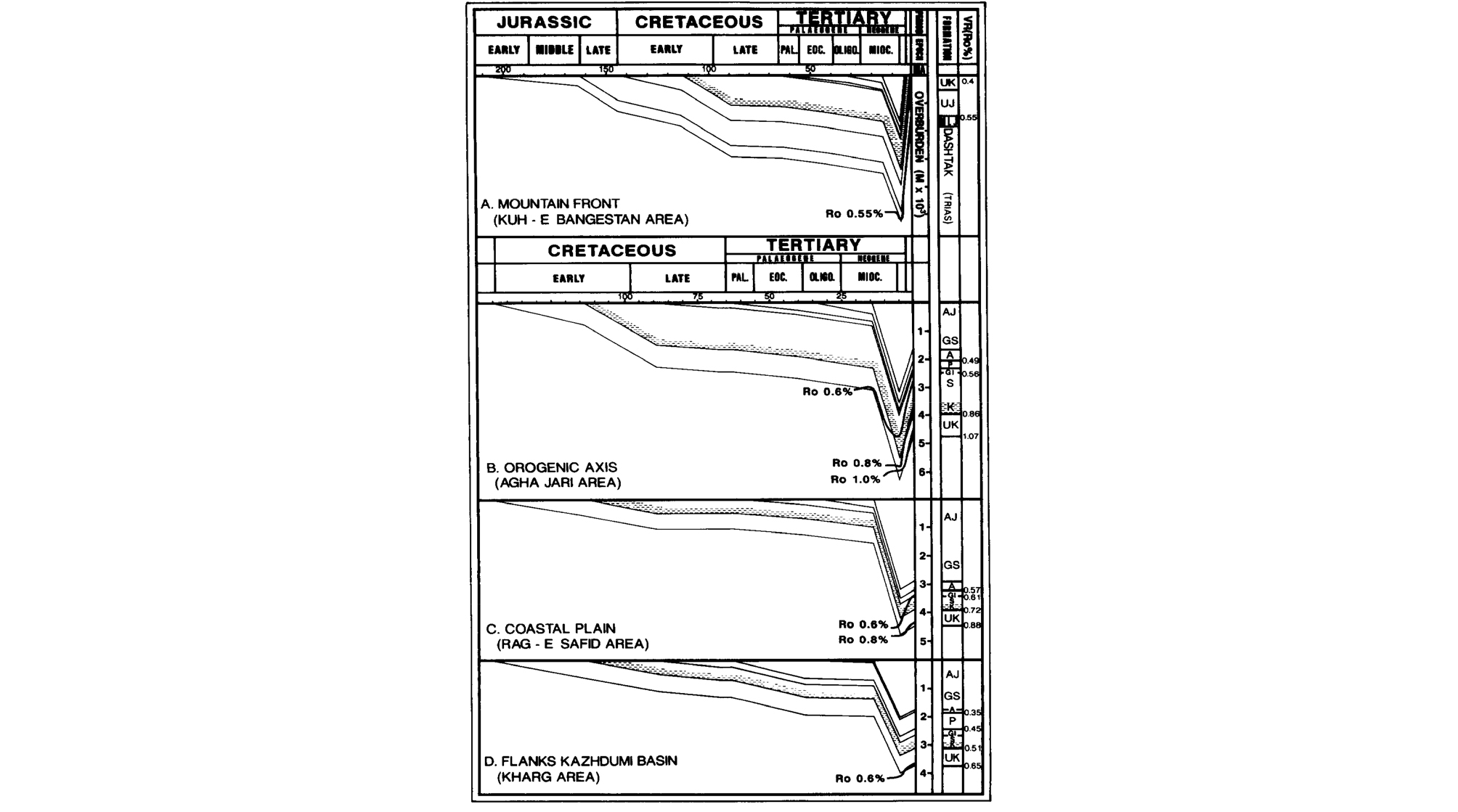
데즈풀의 북동 코너(Karun, Lab E Safid, Lali 유전 등)에서 산출되는 석유들은 중심부 Kazhdumi 기원의 석유와 좀 다른 양상을 보인다(Fig. 40). 데즈풀 북동 코너의 석유는 API 비중이 37°로 가볍고, 황 함량이 0.6%로 낮으며, 탄소 및 황 동위원소 값이 각각 –24.8±0.4‰ PDB와 –7.6±4.4‰ CDT로 Kazhdumi 석유와 확연히 다르고, 신생대 피자 식물에서 유래된 18α(H)oleanane을 포함한다(Bordenave and Burwood, 1990). 근원암은 신생대 고기 테티스 해 소멸 과정에서 몰라세 Kashkan 층, 천해역 탄산염암 Jahrum 및 Shahbazan 층 등과 더불어 오피올라이트 압등대에 평행하게 발달한 침강 곡분에서 퇴적된 Pabdeh 층으로, 유기물 함량이 1~12 %, 유형 type II, 열분해 S2 7~40 mgHC/g dry rock이며, 유기물 함량 1% 이상인 층의 누적 두께가 최대 230 m에 달한다(Fig. 41). Pabdeh 층은 데즈풀 대부분 지역에서 비트리나이트 반사도가 <0.6 %Ro로 석유 생성 단계에 도달하지 못했으며, 루레스탄 지역에서는 평균 유기물 함량이 2~5%이고 성숙도도 >0.6 %Ro로 양호하나 습곡으로 인한 트랩 파손과 저류암인 Asmari 층의 지표 노출로 Pabdeh 기원의 유전이 거의 발견되지 않고, 파르스 지역은 유기물 함량이 <0.8%로 낮다.
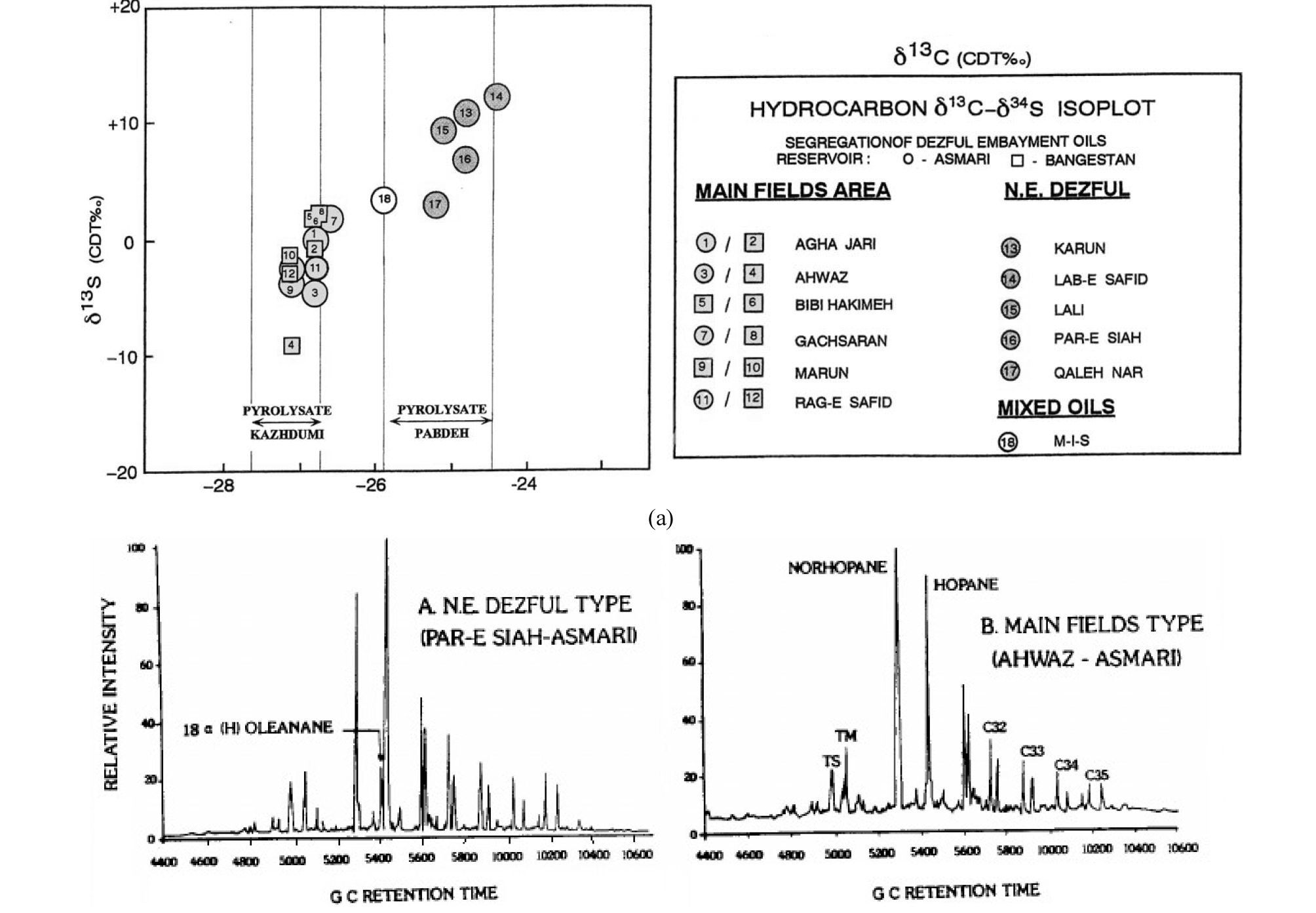
Fig. 40.
(a) Carbon and sulphur isotope crossplot showing differences between Kazhdumi and Pabdeh-sourced oils in the Dezful area, (b) Terpane m/z 191 fragmentograms showing the conspicuous peak of 18 (H) oleanane in the Pabdeh-sourced oil compared to typical Kazhdumi-sourced oil (Bordenave and Burwood, 1990).
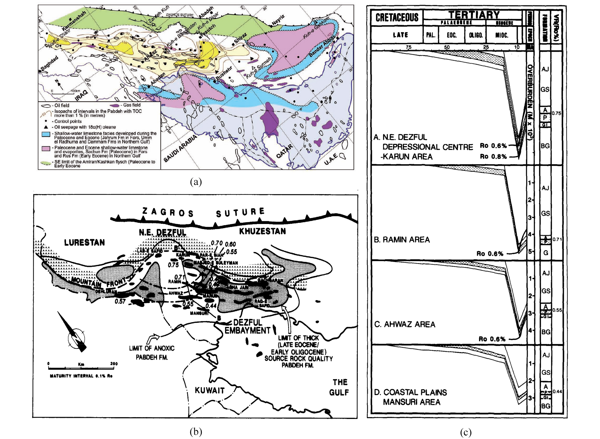
Fig. 41.
Source rock; Pabdeh Formation. (a) Cumulative isopach map of organic-rich layers (TOC>1%) in the Pabdeh Formation (Bordenave, 2014), (b) Vitrinite reflectance iso-maturity contour map of the Pabdeh Formation in the Dezful area. (c) Burial history profiles of the Kazhdumi Formation in the Dezful area (Bordenave and Burwood, 1990). UJ-Upper Jurassic, UK-Upper Khami, K-Kazhdumi, S-Sarvak, GI-Gurpi-Ilam, P-Pabdeh, A-Asmari, GS-Gachsaran, AJ-Agha Jari.
기타 유력한 근원암으로 루레스탄 지역의 대륙붕내 고립된 분지에서 퇴적된 쥐라기 Sargelu 층과 백악기 Garau 층, 백악기 전기 Zubair 사암 등 쇄설 영역의 확장 시기에 파르스 지역에서 퇴적된 Gadvan 층 등이 있다. Sargelu 층은 두께 100~300 m, 유기물 함량은 3~8%의 흑색 이회암으로(Fig. 42), 이라크 북부 및 이란-이라크 국경 부근에 분포하는 유전들의 중요한 근원암으로 알려져 있으나, 루레스탄 지역에서는 두꺼운 Gotnia 증발암이 상부로의 석유 이동을 막아 역할이 미미하다(Bordenave and Hegre, 2010; Bor-denave, 2014). Sargelu 층과 비슷한 분포 양상을 보이는 Garau 층은 하부(Neocomian)에 유기물 함량 1.5~10%, 두께 250 m 이상의 양호한 근원암을 포함하고 있으나, 상부를 두께 500 m 이상의 유산소 환경에서 퇴적된 이회암이 덮고 있어 생성된 석유의 방출이 여의치 않았던 것으로 보인다. Sargelu 층은 에오세(~50 Ma)에 석유 방출 단계, 마이오세(~25 Ma)에 가스 생성 단계에 진입했을 것으로 추정되며, Garau 층은 백악기 후기~마이오세 전기 사이에 석유 방출 단계에 들어섰을 것으로 보인다. Gadvan 층은 전진 구축하는 Zubair 삼각주와 탄산염 대지 사이의 낮은 에너지 환경에서 퇴적된 유기물 함량 ~1%의 한계적 근원암으로 두께 20~100 m의 역청질 이회암이 집적된 파르스 북동 지역의 소규모 유전(Bushgan 32°API, δ13C –24‰, δ34S 1.2‰)에서 흔적이 인지된다(Bordenave and Huc, 1995; Bordenave and Hegre, 2010).
저류암
이란 석유의 대부분은 데즈풀 지역의 Asmari 층과 Sarvak 층에 집중 분포하고, 각각이 자원량의 75% 및 23%를 부존하고 있다(Bordenave, 2014). Asmari 층은 백악기 후기~신생대 고기 오피올라이트 압등으로 형성된 침강 분지를 Amiran, Gurpi, Pabdeh 층 등이 채우고, 남은 퇴적 공간을 본격적인 자그로스 조산운동 이전 올리고세~마이오세 전기 동안 천해역 탄산염암, 삼각주 사암(Ahwaz 층원), 증발암(Kalhur 층원)이 해수면 변동에 따라 순환 조합하며 마무리하는 두께 320~500 m의 순차층이다(Fig. 31(d))(van Buchem et al., 2010; Ehrenberg et al., 2007). 지리적으로 사암 및 쇄설암-탄산염암 혼합 지역이 데즈풀 남서부에 분포하며, 증발암 지역을 사이에 두고, 순수 탄산염암 지역이 데즈풀 북동부 및 파르스 연안으로 연장된다(Fig. 43). Asmari 탄산염암은 완만한 사면에서 퇴적된 유공충을 비롯한 생물 쇄설물과 어란상 입자 등을 다량 포함하는 입자암(grainstone), 혼편암(packstone) 또는 와케암(wackestone)이 주요 암상을 구성하는데(Aqrawi et al., 2006; van Buchem et al., 2010; Vaziri-Moghaddam et al., 2010; Seyrafian et al., 2011), 매몰과 속성 작용으로 공극률과 투과도가 대부분 각각 5%, 5 md 이하로 저하되었다가, 자그로스 구조운동에 수반된 단열로 개선되어 25%, 100 md 이상의 우수한 저류암을 형성한다(Alsharan and Nairn, 2007). 단열은 응력이 가해진 암석에 발생하는 물리적 손상의 결과로, 암석의 물성, 층후, 층간 결합 강도 등에 따라 다양한 양상을 보이는데, 습곡 축에 평행하거나 직교하는 인장성 단열이 주를 이루고, 습곡 축과 사교하며 짝을 이루는 전단성 단열은 드물며, 단열의 밀도는 층후와 역로그함수의 관계를 가진다(McQuillan, 1973, 1974; Gholipur, 1994; Wennberg et al., 2006, 2007; Stephenson et al., 2007)(Fig. 44). 소규모 단열들은 방향성을 구조와 연계시키기 어려운데, 자그로스 습곡 운동 이전에 작용했던 광역적 응력장의 산물 또는 상부 지층의 삭박에 따른 지압력 해소 과정에서 생성된 것으로 추정된다(McQuillan, 1973, 1974). Asmari 층 하부의 Ahwaz 사암은 해안전면부에서 퇴적된 분급도가 좋은 중‧세립 석영질 사암(석영 97.5%, 장석 1.6%, 암편 0.9%)으로(Avarjani et al., 2015), 공극률 35~12%(평균 27.4%), 투과도 3,000~2 md(평균 690 md)의 우수한 물성을 보이며, Ahwaz, Marun 유전 등의 주요 저류층을 구성한다(Bagheri et al., 2005).
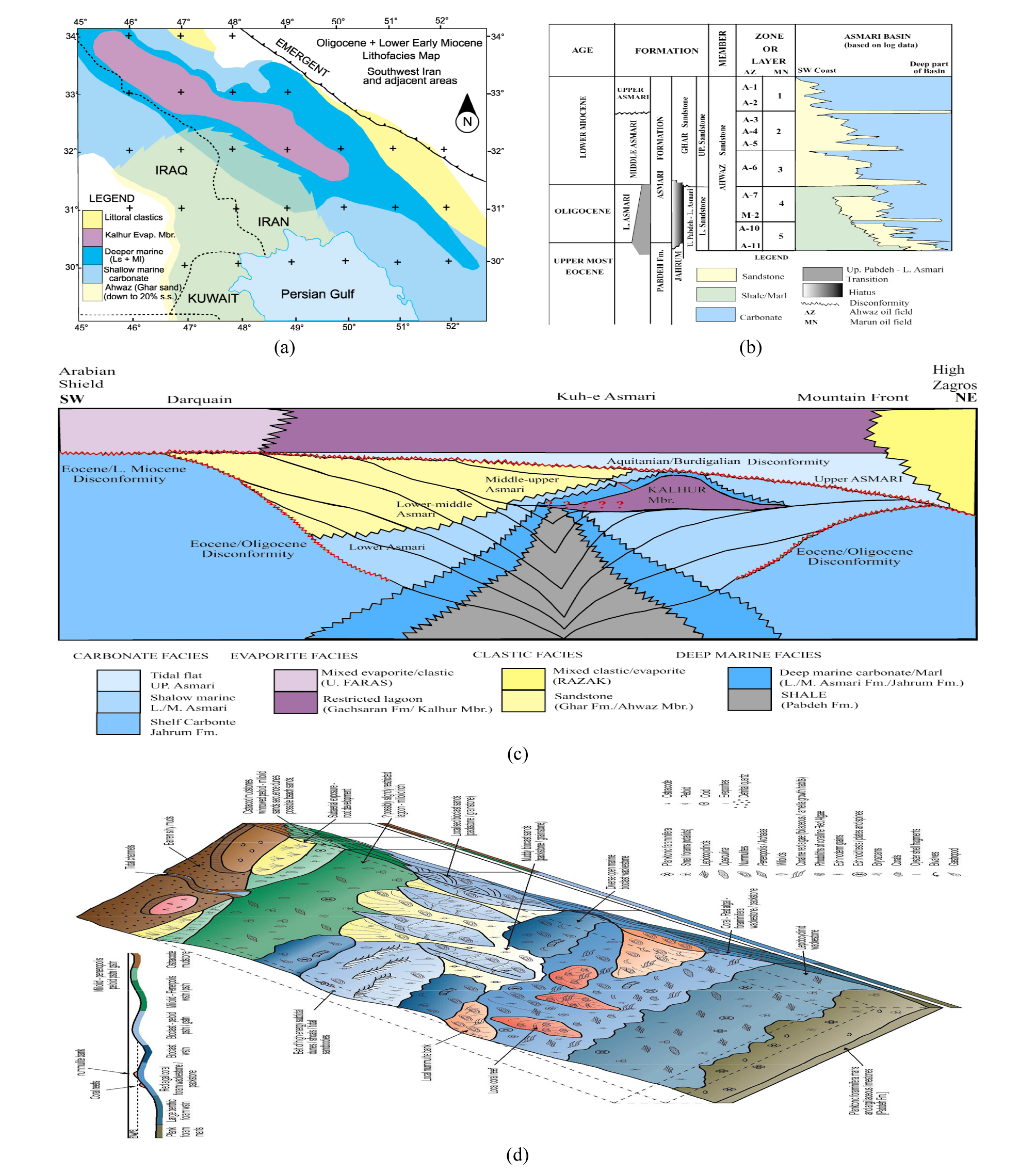
Fig. 43.
Reservoir rock; Asmari Formation. (a) Lithofacies distribution of the Asmari Formation, (b) Sequence stratigraphic organization and distribution of the Ahwaz Sandstone, (c) Regional sequence stratigraphic correlations and facies distribution of the Asmari Formation in the Dezful Embayment (After Ahmadhadi, 2007), (d). Carbonate ramp depositional model for the Asmari Formation (After Aqrawi et al., 2006).
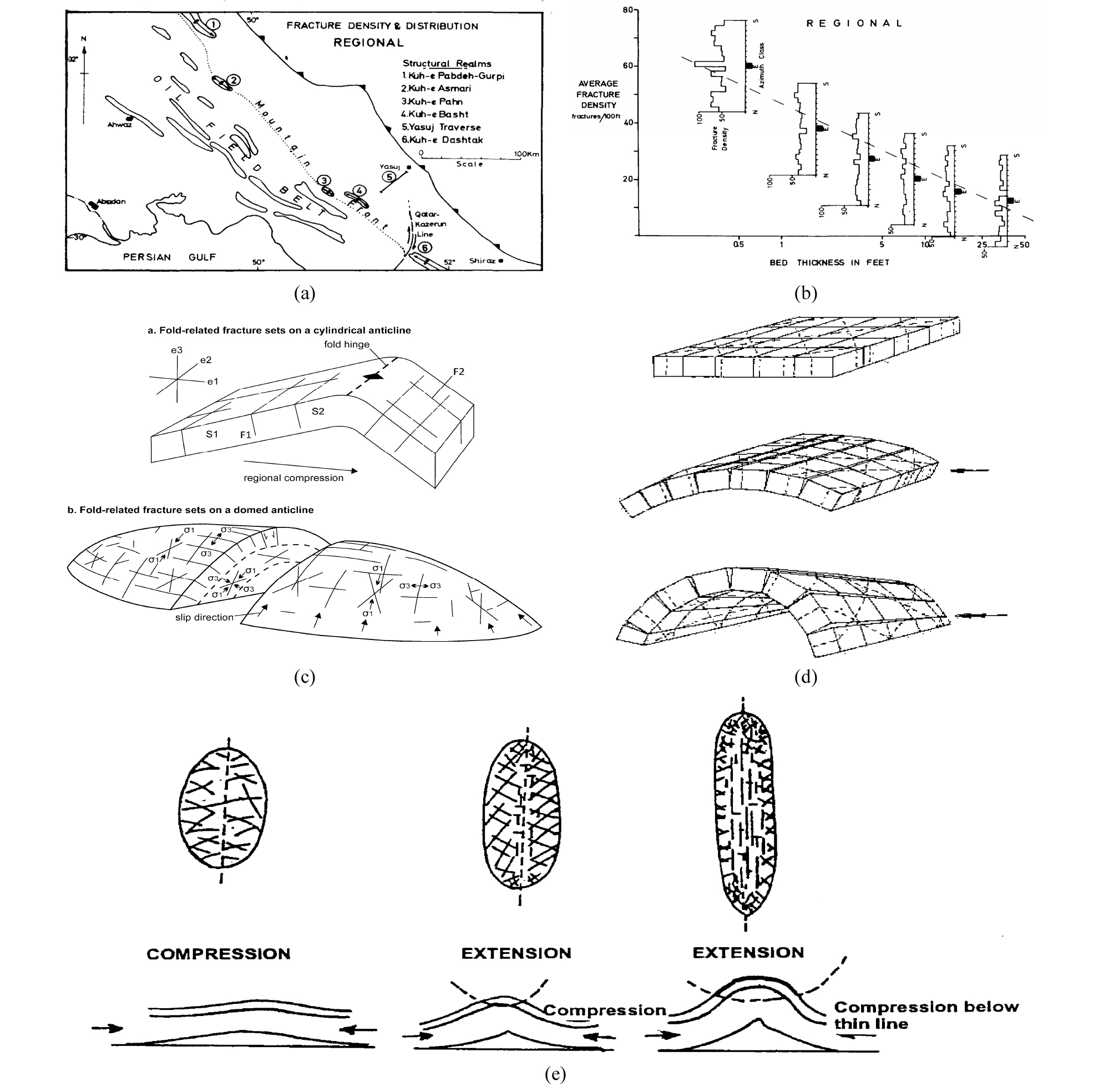
Fig. 44.
Fracture development in the Asmari Formation and conceptual models for the relationship between fracturing and folding. (a) Location map where fracture data came from, (b) Diagram showing relation between bed thickness and fracture density. Histograms represent density distribution by azimuth class for each bedding class (McQuillan, 1973). (c)-a. Relationship among major fracture sets in an asymmetric anticline; tensional fractures parallel to the fold axis (F1), tensional fractures perpendicular to the fold axis (F2), and conjugate shear fractures with an acute bisector parallel to regional compression and e1 (S1 and S2) (Price, 1966; Modified by Watkins et al., 2017), b. Fracture sets developed on a dome-shaped anticline; fracture orientations vary depending on structural position/orientation of the slip direction (Stearns, 1969; Modified by Watkins et al., 2017), (d) Fracture development while folding a bed with pre-existing fracture sets (McQuillan, 1973), (e) Fracture development with growth of a concentric fold (Golipour, 1994); First stage shorten by flexural slip mechanism, and second stage shorten with stretching by axial growth of the fold as well.
Sarvak 층은 Zubair로부터 Burgan으로 이어지던 쇄설암 영역의 확장이 멈추고, 탄산염암 퇴적이 복원되었던 백악기 세노마눔세~튀롱세(Cenomanian~Turonian) 천해역에서 번성하던 쌍각조개류 루디스트(rudist)를 다량 포함하는 저류층으로(Taghavi et al., 2007; Razin et al., 2010; van Bouchem, 2011; Vincent et al., 2015; Esrafili-Dizaji et al., 2015)(Fig. 45), 하부의 Kazhdumi 층과는 정합 관계이고, 상부는 광역적 부정합면으로 깊은 삭박과 카르스트화를 보인다. 저류층은 단열 및 백운석화 등에 의한 2차 공극 발달로 공극률이 7~14%이며, 총(gross) 두께는 24~790 m이고, 순(net) 두께는 5~285 m이다. 단열은 Asmari 층과 마찬가지로 습곡축에 평행하거나 직교하는 인장성 단열과 방향성이 습곡에 연계되지 않은 단열이 함께 나타난다. 백운석화는 열수 기원이며 통로로 작용하는 단층과 단열 주변에 주로 발달하고, 원암의 암상 및 퇴적 조직에 따라 범위가 변화한다(Sharp et al., 2010). Sarvak 층은 Asmari 층에 비하여 가벼운 유종과 가스를 생산하는데, Bibi Hakimeh (석유), Ahwaz, Binak Hendijan, Mansuri (석유, 가스), Tang-i-Bijar (가스액) 유전이 대표적이며(Alsharan and Nairn, 2007), Asmari 층과 연결되어 오일-물 접촉면을 공유하거나 압력적으로 상호 소통한다(e.g., Gacharan, Bibi Hakimeh)(Ala, 1982). Sarvak 층의 원유는 Asmari 층의 원유와 동위원소, 가스크로마토그래피 등 유기지화학적으로 유사하여 동일한 근원암, 즉 Kazhdumi 층으로부터 유래되었음을 시사한다(Ala et al., 1980; Ala, 1982; Bordenave and Burwood, 1990; Alizadeh et al., 2007).
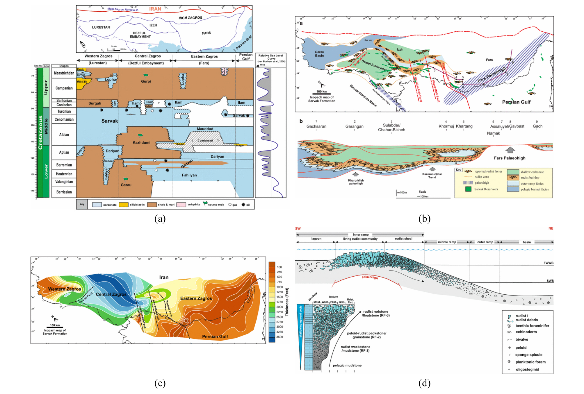
Fig. 45.
Reservoir rock; Sarvak Formation (Esrafili-Dizaji et al., 2015). (a) Cretaceous lithostratigraphy of Zagros, (b) Lithofacies distribution of the Sarvak Formation. Note the rudist belts form over paleohighs. (c) Isopach map of the Sarvak Formation. Note that there was an intrashelf basin in the central Zagros, but the Fars was shallow during the deposition of the Sarvak Formation, (d) Depositional model for the Sarvak Formation.
Dalan/Kangan 층은 페름기~트라이아스기 아라비아 대지로부터 테티스 해와의 경계부(현재 MZT)에 이르는 세계 최대 규모의 연해 완사면에서 퇴적된 Khuff 층에 대비되는 탄산염암-증발암의 순환 퇴적층으로, 파르스 연안과 페르시아 만에 분포하는 막대한 양의 가스의 저류암을 형성한다(Szabo and Kheradpir, 1978; Kashfi, 2000; Insalaco et al., 2006; Esrafili-Dizaji and Rahimpour-Bonab, 2013; Bashari, 2016). 연해는 경사가 매우 완만하고 지형적으로 평탄하여, 암상 및 퇴적상이 광대한 영역에 걸쳐 일정한 반면에, 해수위 변화에 민감하여 수직적 변동이 심하다. 이상적인 저류암은 얕은 조하대 모래톱에서 파도와 해‧조류의 끊임없는 교란을 받으며 퇴적된 어란상 또는 생물 쇄설물로 이루어진 입자암 및 혼편암으로(Fig. 27), Dalan 층 상부의 K3, K4 구간과 Kangan 층의 K1, K2 구간에 분포한다(Fig. 46). 공극률은 압밀과 교질 작용에 의해 깊이에 따라 감소하는 일반적인 경향을 보이며, 지리적으로는 파르스 내륙의 4% 미만에서 해상 10% 이상으로 양호해지는데, 북동으로부터 남서 방향으로 얕아지면서 세립질 입자의 구성비가 줄어들고 분급이 좋아지는 원래의 광역적 퇴적 추세를 반영한다(Ehrenberg et al., 2007; Esrafili-Dizaji and Rahimpour-Bonab, 2013)(Fig. 47). 탄산염암의 공극률은 입자 크기, 형태, 분포 등 원래 퇴적 조직과 매몰 및 속성 과정에서의 압밀 및 교질 작용, 용해, 용식, 백운석화, 단열 등에 의해 좌우되는데, Dalan/Kangan 층은 백운석화, 담수대에서의 용해 작용, 단열 등이 공극률 및 투과도 향상에 크게 기여하고 있으며, 경석고 충전, 용식 등이 저하 요인으로 작용한다. 대표적인 가스전인 South Pars (원시매장량 500 Tcf, 채굴가능매장량 360 Tcf)의 저류 물성 분석에 의하면, 어란상 또는 생물 쇄설물로 이루어진 입자/혼편암과 해조류의 결속암(boundstone)인 thrombolite/stromatolite이 우량한 저류암을 구성하고, 내부 완사면의 석호에서 퇴적된 와케암과 경석고가 많이 포함된 조상대 퇴적상은 공극률과 투과도 면에서 열등하다(Esrafili-Dizaji and Rahimpour-Bonab, 2009). 백운석화로 암상이 백운석암 60%, 석회암 30%, 경석고암 10%로 바뀌었으며, 백운석암이 석회암에 비해 공극률은 낮으나, 투과도가 상대적으로 높은 경향을 보인다. 공극 유형은 용해 작용로 인해 확장 또는 주형(mould)을 형성하는 2차 공극이 60%를 상회하고, 입자간 또는 창문형(fenestral) 공극 등 1차 공극은 20% 미만이며, 단열 공극이 13%, 결정간 공극이 7% 등이다. 공극은 교질물의 양이 많을수록, stylolite의 밀도가 높을수록 줄어들고, 경석고 교질이 방해석 교질에 비해 효과적으로 투과도를 떨어뜨린다.
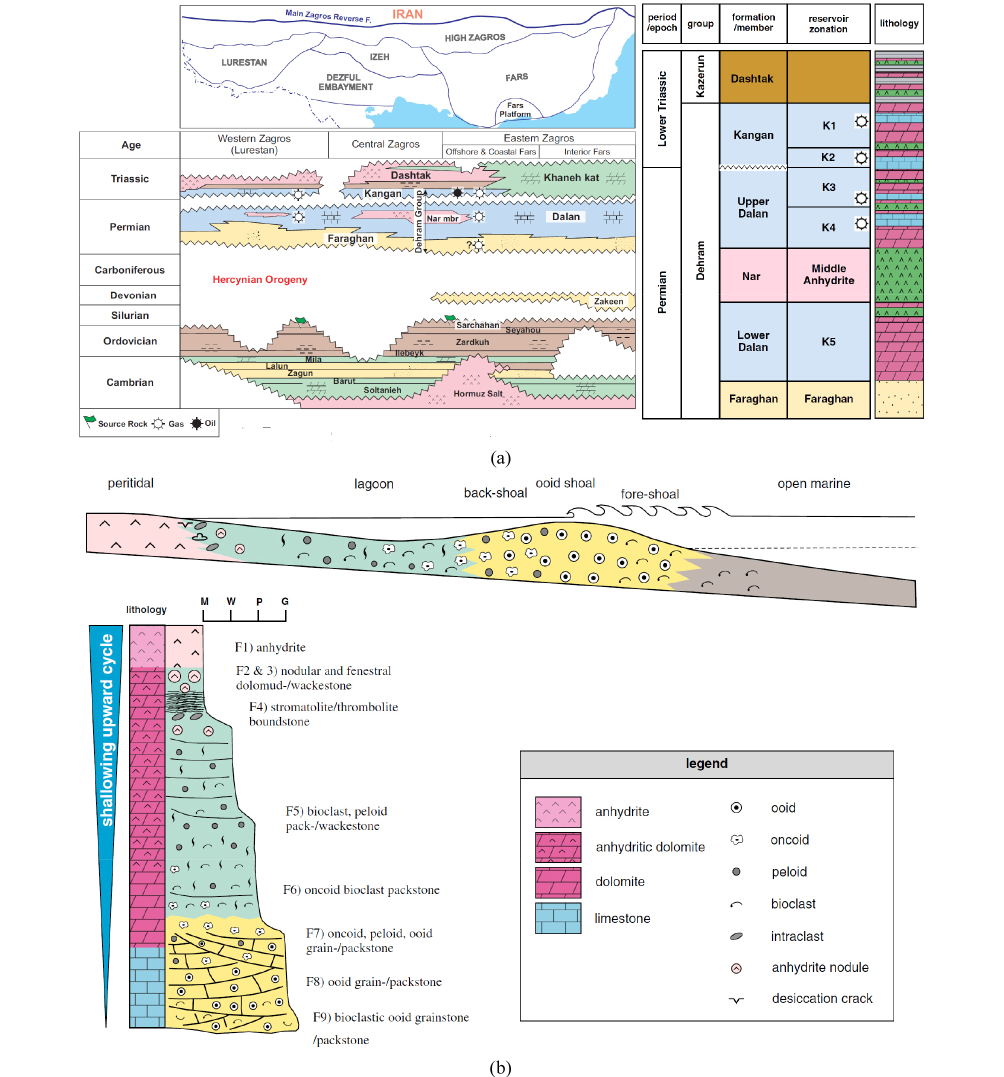
Fig. 46.
Reservoir rock; Dalan/Kangan Formations. (a) Regional extent, stratigraphic position, equivalents and lithology of the Dalan/Kangan Formations (Esrafili-Dizaji and Rahimpour-Bonab, 2013). The main reservoir intervals are the Upper Dalan and Kangan units (K1, K2, K3 and K4); the Nar and Lower Dalan Members (K5) are important reservoirs in some fields. The Triassic Dashtak Formation provides an efficient seal. (b) Depositional model for the Dalan/Kangan Formations (Esrafili-Dizaji and Rahimpour-Bonab, 2014).
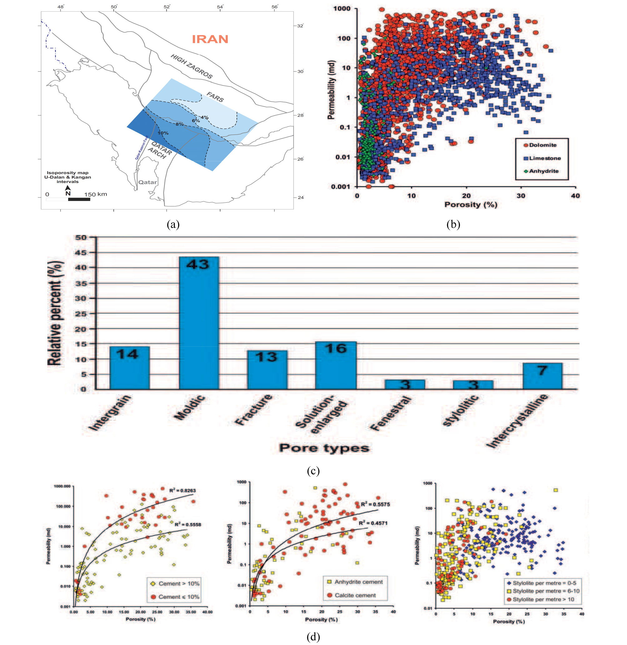
Fig. 47.
(a) Iso-porosity map for the Upper Dalan/Kangan reservoirs (Esrafili-Dizaji and Rahimpour-Bonab, 2013), (b) Porosity-permeability cross-plot for the Dalan/Kangan reservoirs in the South Pars gas field. Note that the anhydritic interval shows low porosity, and dolomitic intervals are more permeable than the limestone and anhydrite at similar porosity values, (c) Pore types and their relative proportions in reservoir rocks of the South Pars gas field, (d) Porosity-permeability cross-plots illustrating the importance of cement quantity, types, and stylolitic frequencies in the reservoir. With an increase in cement abundance, the poro-perm values decrease. Calcite-cemented facies shows better poro-perm values than the anhydrite-cemented facies. Poro-perm decreases as the stylolitic density increases.
덮개암
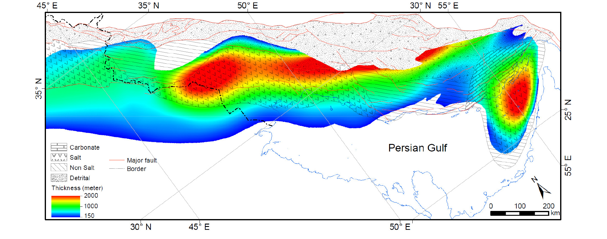
덮개암은 저류층 상부에 위치하는 불투성 암석으로, 탄화수소의 유출을 막는 역할을 담당한다. Kazhdumi 층으로부터 생성된 석유를 함유하는 Asmari 층과 Sarvak 층에 대해서는 두꺼운 Gachsaran 층의 증발암이 덮개암으로 작용하고, Sarvak 층 상부의 Gurpi, Pabddh 층은 암상이 치밀한 셰일, 이회암 또는 세립질 탄산염암임에도 불구하고 단열로 인하여 그 역할은 제한적이다(Alsharan and Nairn, 2007). Gachsaran 층은 신생대 신기 전진하는 자그로스 조산대 전면에 형성된 굴곡(flexural) 분지의 하부를 채우는 암염, 경석고, 석고 등으로 이루어진 증발 퇴적암체로, 데즈풀 지역 등을 퇴적 중심으로 하여 스러스트 벨트에 평행하게 폭 150 km 내외로 2,000 km 연장하며 분포한다(Fig. 28)(Gill and Ala, 1972; Kashfi, 1980; Bahroudi and Koyi, 2004; Pirouz et al., 2011). 두께는 수백~2,000 m이며, 동쪽으로는 카제룬 단층을 경계로 급격히 얇아지고 암염층이 사라지며, 북쪽으로는 Razak 층의 이회암과 지교하며 퇴적상이 변화한다.
Dalan/Kangan 가스층에 대해서도 증발암이 주도적인 덮개암 역할을 한다(Bordenave, 2008, 2014). Kangan 층 상부의 Dashtak 층은 4개의 증발암 구간을 포함하며, 두께가 가스전이 분포하는 파르스 연안의 Gavbendi 융기대에서 550~850 m 이고, 남쪽 페르시아 만으로는 쥐라기 이전의 무퇴적 또는 삭박으로 400 m 이하로 얇아지며, 북쪽으로는 HZ 부근에서 탄산염암 퇴적상의 Khaneh Kat 층으로 대체된다(Fig. 32)(Szabo and Kheradpir, 1978; Najafi et al., 2014).
트랩
자그로스 구조운동에 의해 형성된 산자락(foothill)의 배사 습곡들이 데즈풀에 집중 분포하는 유전들의 트랩을 형성한다(Fig. 18)(Sherkati et al., 2006; Witte and Schönike, 2016). 배사들은 진폭 6,000 m, 파장 8~16 km으로 100 km 이상 연장되기도 하며, Gachsaran, Marun, Ahwaz, Agha Jari 등의 초거대 유전(>100억 배럴)과 12개의 거대 유전(>5억 배럴)을 비롯한 60여개의 유전들의 둥지 역할을 하고 있다. 트랩은 습곡 축의 굴곡과 경사에 따른 구조적 폐쇄(closure)에 의해 완성되며, 가스캡 또는 액상으로 이루어진 불포화 유층을 포함한다. 정부(crest)와 배수점(spill point) 사이의 높이 차이는 저류층인 Asmari 층준에서 1,200~2,100 m이고, 대부분이 배수점까지 채우고 있다(Bordenave and Hegre, 2011; Nemcok et al., 2009; Alsharan and Nairn, 2007)(Fig. 48). 트랩내 Asmari 층은 치밀한 편이나 단열에 의한 공극망이 잘 발달되어 생산에 따른 압력 반응이 수십 km 떨어진 유정에서도 즉각적이며, 하부의 Bangestan 저류층과의 이격이 600~900 m 정도임에도 불구하고 유체 정역학적으로 연계되어 있어 산출되는 오일의 성분과 유형이 동일하다.
파르스 연안의 가스전들은 카제룬 단층 동쪽 카타르 융기대 연장선 상의 단순 습곡대에 위치한다. 트랩은 호르무즈 암염 층을 미끄럼면으로 하여 좌굴에 의해 발달한 대칭형의 평행 배사습곡들이 담당한다(Fig. 49). 이 지역의 습곡들은 파장이 일정하며(~16 km), 진폭이 작고(500-1,000 m), 축 길이가 비교적 짧다(<50 Km)(Jahani et al, 2009; Mouthereau et al., 2006, 2007a; Sattarzadeh et al., 2002)(Fig. 46). Kangan, Nar, Aghar, Shanol, Varavi 등 채굴가능 매장량 10 Tcf 이상의 거대 가스전을 비롯한 16개의 비수반 가스전들이 발견되었으며, 면적 규모는 5~12×22~60 Km로 알려진다(Bordenave, 2008; Esrafili-Dizaji and Rahimpour-Bonab, 2013).
페르시아 만에는 암염 돔을 핵으로 한 트랩이 발달하며, Kish (50 Tcf), North Pars (47 Tcf), Golshan (45 Tcf), Ferdowsi (9 Tcf), Lavan (9 Tcf) 가스전 등이 여기에 속한다(Ghazban, 2007). 페르시아 만 해상에 분포하는 돔 구조들은 자그로스 배사의 중심 또는 축선 상에 위치하거나 스러스트 또는 주향 단층을 따라 분포하며 지표에 올라와 있는 육상의 돔들과 달리, 대부분이 완만하게 융기한 암염침(salt pillow)이고 상부 층들이 쌓이면서 중심부는 얇고 주변으로 두꺼워지는 드레이프(drape) 형태의 트랩을 형성한다. 트랩은 평면이 원형 또는 타원형이며, 규모는 6~15×12~35 Km이다.
South Pars/Qatar North 가스전의 호스트 역할을 하고 있는 카타르 융기대의 가스 트랩은 면적이 9,700 km2로 거대하며, 원시자원량 1,800 Tcf, 채굴가능 매장량 1,260 Tcf로 전세계 확인매장량의 ~20%를 부존하고 있다(Fig. 50). 카타르 융기대는 기반암을 수반한 지괴 단층 운동에 의해 형성된 지루 구조로, 아라비아 판 고유의 북동-남서 방향(Najd Trend)으로 발달하여 호르무즈 암염 분지를 분리시키고 있으며, 후기의 응력 변화에 반응하면서 반복적으로 재동한 흔적을 보인다(Perotti et al., 2011; Al-Husseini, 2000; Konert et al., 2001; Edgell, 1996; Talbot and Alavi, 1996). 트랩의 충전 시기는 주변 가스 생성지(kitchen)에서의 실루리아기 근원암이 가스를 본격적으로 방출하기 시작하는 백악기 후기 이후로 추정되며, 일부에서 제기되고 있는 트랩 내에서 오일의 열적 분해에 의한 가스 생성은 매몰 심도 및 낮은 황 함량 등을 고려할 때 확실치 않다(Bordenave, 2008; Bordenave and Hegre, 2010; Aali et al., 2006; Aali and Rahmani, 2011, 2012; Saberi and Rabbani, 2015; Ghazban, 2007).
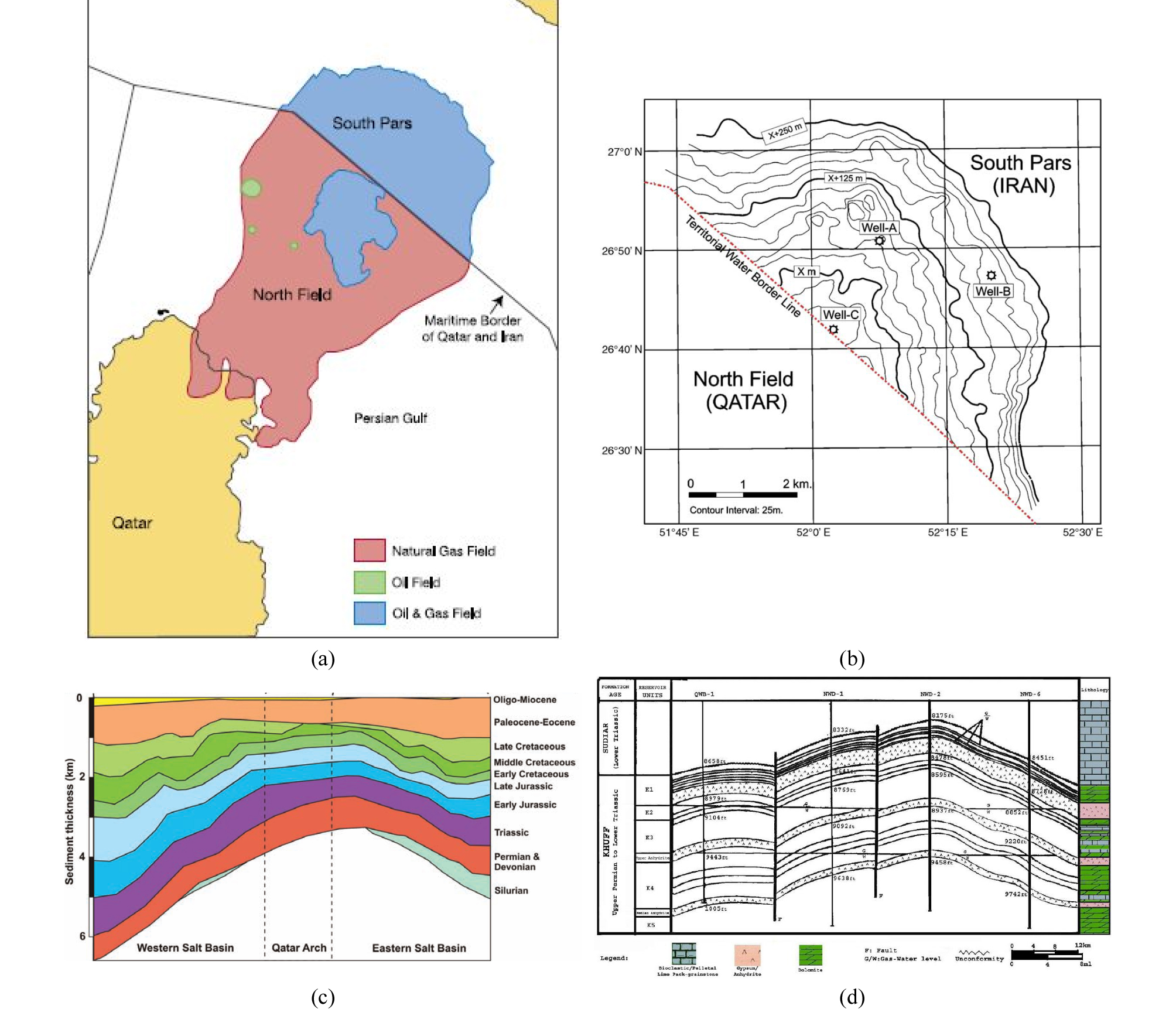
Fig. 50.
Trap: South Pars. (a) Map of the South Pars-Qatar’s North super-giant gas fields. Also shown is oil or oil and gas reservoired in the younger horizons other than the Dalan/Kangan Formations, (b) Schematic structure map of the South Pars field (Aali et al., 2006), (c) Stratigraphic cross-section across the Qatar Arch and Western and Eastern sub-basins (Rahimpour-Bonab et al., 2010) Thickness variations reflect evolution of the Qatar Arch through time, (d) Cross-section of the South Pars-North fields illustrating main reservoir zones and stratigraphy (Bashari, 2009).
결론
이란은 지난 2016년 1월 16일을 기해 핵 개발과 관련된 각종 경제적 제재가 해제됨에 따라, 석유‧가스 분야에 대한 새로운 투자 유치를 활발히 진행하고 있다. Total, Shell, Eni 등 IOC를 비롯한 러시아, 중국, 일본, 말레이시아, 태국 등 세계 각국의 석유기업들이 적극적으로 응하여 협상에 임하고 있음에도 불구하고, 우리나라는 최순실 국정농단 사건, 박근혜 대통령 파면, 대통령 선거, 정권 교체 등의 정치‧사회적 상황과 소위 ‘사자방(4대강, 자원, 방산)’ 비리로 얽혀 제대로 대응을 하지 못했고, 에너지 공기업들은 기능을 상실하여 중동의 석유 자원을 확보할 수 있는 천금같은 기회를 속수무책으로 놓치고 있어 안타깝다.
이란은 석유와 가스의 확인매장량이 157.8 Bbbl, 1201.4 Tcf로 각각 세계 4위, 2위의 자원부국이며, 우리와는 1962년 수교 이후 긴밀한 경제 협력 관계를 유지해온 중동의 우방국으로, 1970년대 2만여 명의 노동자들이 파견된 건설 붐으로 압축 성장에 이바지하였다. 이슬람 혁명 후 각종 제재가 가해진 기간 중에도 상당한 규모로 교역이 이루어져 상호 신뢰가 쌓인바, 다소 늦었지만 우리가 총력을 다해 나서면 이란 석유 개발 사업에 참여할 수 있는 기회가 올 수도 있다.
이란은 아라비아 판과 유라시아 판이 분리되고, 충돌하는 한복판을 점하는 독특한 지체 구조 환경에서 다양한 양상의 퇴적 분지들이 발달하여 풍요로운 석유 시스템을 구축하고 있다. 특히 자그로스 지역은 이란 블록이 곤드와나 초대륙으로부터 분리되고 테티스 해가 생성되면서 형성된 광대한 천해역 대륙붕에서 페름기 이후 탄산염암이 주도적으로 퇴적하여 양질의 저류암들이 널려 있고, 해퇴 주기에 석호 또는 사브카 환경에서 퇴적된 증발암의 불투성이 효과적으로 석유 유출을 방지한다. 근원암은 실루리아기 간빙기에 빙하가 녹으면서 해수면이 최대 상승한 해침기에 퇴적된 Sarchahan 층, 중생대 대륙붕 상에 빈번하게 발달했던 소분지의 고립된 무산소 환경에서 퇴적된 Kazhdumi 층 등과 자그로스 조산대의 구조적 하중에 의해 형성된 전면 분지에서 쌓인 신생대 Pabdeh 층이 담당한다.
석유는 데즈풀 전면 분지에 집중 분포하고, 자그로스 구조 운동으로 발달한 습곡의 배사 내 단열이 잘 발달된 올리고세 Asmari 층에서 대부분 생산된다. 백악기 후기 Bangestan 층군이 부차적인 저류층을 구성하는데, Asmari 층과 압력적으로 소통하며, 유사한 성분과 유형의 원유를 생산한다. 가스는 파르스 연안의 단순 습곡대와 카타르 융기대의 거대한 배사 트랩에서 생산되는데, 페름기~트라이아스기 Dalan/Kangan 층이 주 저류층을 구성한다. 특히 카타르 융기대의 South Pars 가스전은 카타르 North 가스전과 저류층을 공유하는데, 채굴가능 매장량이 합쳐서 1,260 Tcf에 달하는 지구상의 최대 가스전으로 이란의 최우선 순위에 꼽히는 개발 대상이다. 제재 해제로 세계 각국의 유수 석유 기업들이 경쟁적으로 개발 참여를 원하고 있어, 과거 GS건설, 현대건설, 대림산업 등이 초기 개발 단계의 플랜트 건설 사업을 수행한 바 있으나, 개발‧생산 등 상류 부문의 진출 없이는 우리 기업의 지속적인 참여가 어려울 수 있다. 정부의 적극적인 지원과 국영 에너지 기업들의 동반이 해결책으로 판단되는데, 비리와 실패로 얼룩진 과거 경험과 역량 부족이 극복해야 할 과제이다.
